ABISKO


Location

lon / lat [deg]: 18.817 / 68.35

Source network: AERONET


Geostationary surface albedo (GSA) data


“+000”


“+057/+063”


Landcover information (based on ESA CCI landcover data)


Landcover fractions @ 2km distance


Landcover fractions @ 20 km distance


Legend


Distance to open water bodies [km]:

1.09

Distance to urban areas [km]:

34.68


Radius: 1 km

Number of landcover classes:

3

Dominant landcover type:

70: Tree cover, needleleaved, evergreen, closed to open (>15%)

Fraction of dominant landcover type [%]:

54.0


Radius: 2 km

Number of landcover classes:

4

Dominant landcover type:

70: Tree cover, needleleaved, evergreen, closed to open (>15%)

Fraction of dominant landcover type [%]:

55.0


Radius: 5 km

Number of landcover classes:

6

Dominant landcover type:

70: Tree cover, needleleaved, evergreen, closed to open (>15%)

Fraction of dominant landcover type [%]:

37.0


Radius: 10 km

Number of landcover classes:

6

Dominant landcover type:

210: water bodies

Fraction of dominant landcover type [%]:

32.0


Radius: 20 km

Number of landcover classes:

7

Dominant landcover type:

150: Sparse vegetation (tree, shrub, herbaceous cover) (<15%)

Fraction of dominant landcover type [%]:

31.0


Disturbances


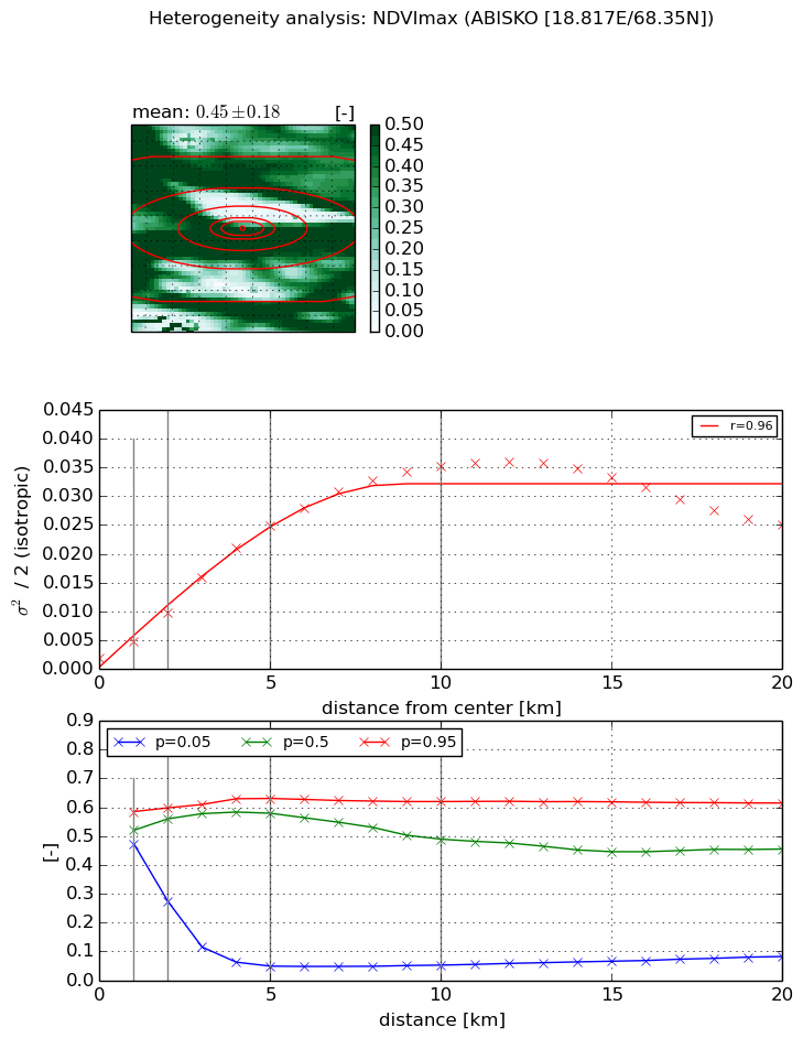
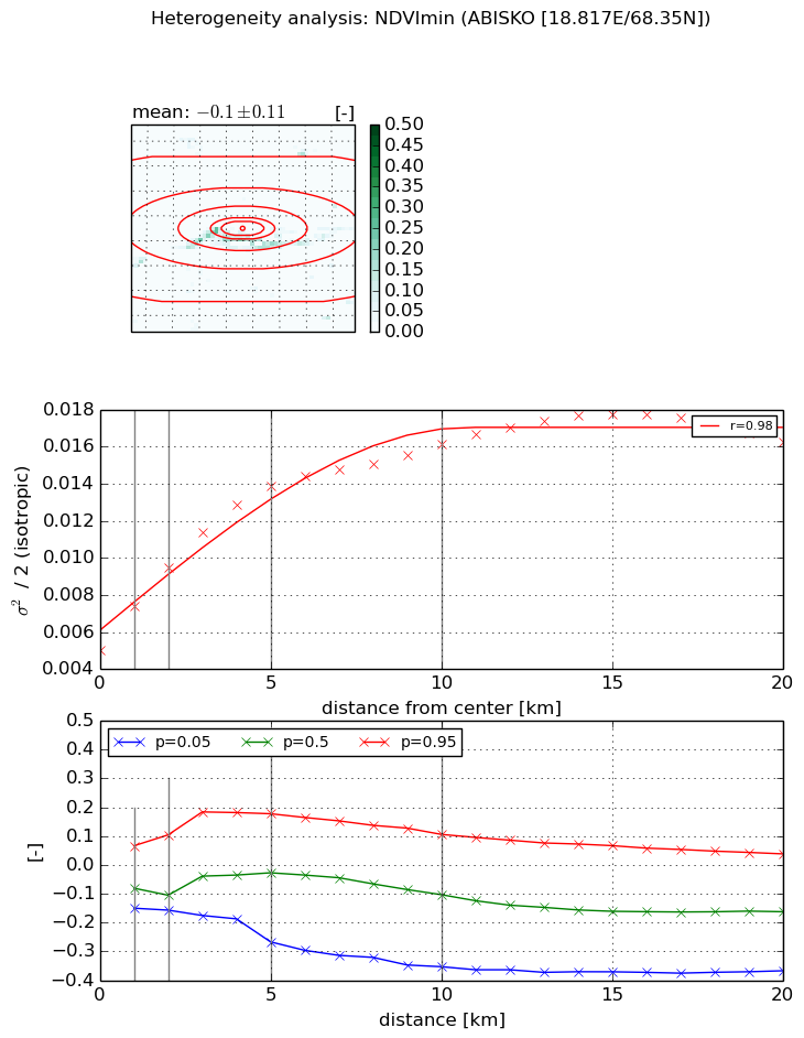
Heterogeneity analysis

The heterogeneity analysis provides information about the spatial and temporal heterogeneity of the site.

Topography


Roman et al. (2009) index


St

3.95649547634e-05

Rcv

0.952610829917

Rse

0.0

Rst

0.0425381394171

Rsv

75823.6839879


Height range @ 1km [m]

75

Height range @ 2km [m]

148

Height range @ 5km [m]

335

Height range @ 10km [m]

-999

Height range @ 20km [m]

-999


Variance slope @ 1 km

3208

Variance slope @ 2 km

4905

Variance slope @ 5 km

5291

Variance slope @ 10 km

-999

Variance slope @ 20 km

-999


NDVI (max. NDVI composite)


Roman et al. (2009) index


St

3.23493776478

Rcv

0.356920334266

Rse

0.0

Rst

-0.091428381746

Rsv

0.479026157366


NDVI range @ 1km [-]

0.11

NDVI range @ 2km [-]

0.32

NDVI range @ 5km [-]

0.58

NDVI range @ 10km [-]

0.57

NDVI range @ 20km [-]

0.53


Variance slope @ 1 km

0.00304812911402

Variance slope @ 2 km

0.00400405553918

Variance slope @ 5 km

0.00486071641618

Variance slope @ 10 km

0.00353665907206

Variance slope @ 20 km

0.00105822157981


NDVI (min. NDVI composite)I


Roman et al. (2009) index


St

4.15398390479

Rcv

-0.405419799817

Rse

0.0

Rst

-0.220023973277

Rsv

-0.0967544993991


NDVI range @ 1km [-]

0.22

NDVI range @ 2km [-]

0.26

NDVI range @ 5km [-]

0.44

NDVI range @ 10km [-]

0.46

NDVI range @ 20km [-]

0.41


NDVI slope @ 1 km

0.00239075000798

NDVI slope @ 2 km

0.00223863697286

NDVI slope @ 5 km

0.00179345483173

NDVI slope @ 10 km

0.00103180407314

NDVI slope @ 20 km

0.000489513660919


Temporal stability analysis

+000 deg (BHR)


BHR statistics

Temporal stability [1/decade]:


abs

rel


Weighted least square:

-99999.0


Ordinary least square:

-99999.0


Probabilities that GCOS criteria is met:

Weighted least square:

-99999.0 %

Ordinary least square:

-99999.0 %


DHR statistics

Temporal stability [1/decade]:


abs

rel


Weighted least square:

-99999.0


Ordinary least square:

-99999.0


Probabilities that GCOS criteria is met:

Weighted least square:

-99999.0 %

Ordinary least square:

-99999.0 %


+057/+063 deg (BHR)


BHR statistics

Temporal stability [1/decade]:


abs

rel


Weighted least square:

-99999.0


Ordinary least square:

-99999.0


Probabilities that GCOS criteria is met:

Weighted least square:

-99999.0 %

Ordinary least square:

-99999.0 %


DHR statistics

Temporal stability [1/decade]:


abs

rel


Weighted least square:

-99999.0


Ordinary least square:

-99999.0


Probabilities that GCOS criteria is met:

Weighted least square:

-99999.0 %

Ordinary least square:

-99999.0 %


Temporal anomaly analyis

The variance of the temporal anomalies provides an additional measure about the stability of the signal AFTER removal of the mean seasonal cylce.

+000 deg


+057/+063 deg