BELMANIP_00263


Location

lon / lat [deg]: -6.9699 / 53.9013

Source network: BELMANIP


Geostationary surface albedo (GSA) data


“+000”


“+057/+063”


Landcover information (based on ESA CCI landcover data)


Landcover fractions @ 2km distance


Landcover fractions @ 20 km distance


Legend


Distance to open water bodies [km]:

3.85

Distance to urban areas [km]:

1.25


Radius: 1 km

Number of landcover classes:

2

Dominant landcover type:

130: grassland

Fraction of dominant landcover type [%]:

78.0


Radius: 2 km

Number of landcover classes:

3

Dominant landcover type:

130: grassland

Fraction of dominant landcover type [%]:

88.0


Radius: 5 km

Number of landcover classes:

3

Dominant landcover type:

130: grassland

Fraction of dominant landcover type [%]:

96.0


Radius: 10 km

Number of landcover classes:

1

Dominant landcover type:

130: grassland

Fraction of dominant landcover type [%]:

97.0


Radius: 20 km

Number of landcover classes:

5

Dominant landcover type:

130: grassland

Fraction of dominant landcover type [%]:

94.0


Disturbances


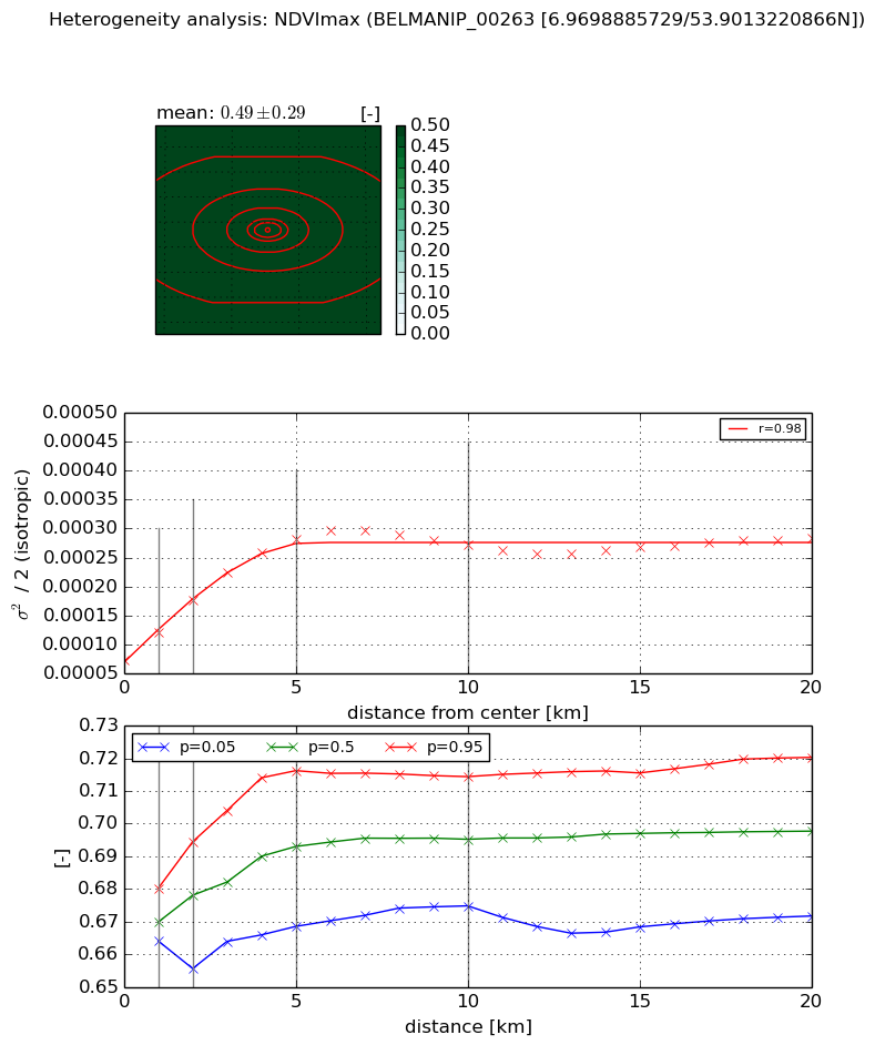
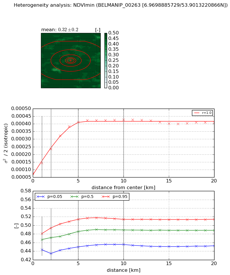
Heterogeneity analysis

The heterogeneity analysis provides information about the spatial and temporal heterogeneity of the site.

Topography


Roman et al. (2009) index


St

2.06961793116

Rcv

0.541885302898

Rse

0.0

Rst

-0.0363198060485

Rsv

0.87133780177


Height range @ 1km [m]

34

Height range @ 2km [m]

50

Height range @ 5km [m]

96

Height range @ 10km [m]

-999

Height range @ 20km [m]

-999


Variance slope @ 1 km

355

Variance slope @ 2 km

282

Variance slope @ 5 km

175

Variance slope @ 10 km

-999

Variance slope @ 20 km

-999


NDVI (max. NDVI composite)


Roman et al. (2009) index


St

6.68930363105

Rcv

0.0214091272907

Rse

0.0

Rst

-0.0951363832365

Rsv

0.331931665195


NDVI range @ 1km [-]

0.02

NDVI range @ 2km [-]

0.04

NDVI range @ 5km [-]

0.05

NDVI range @ 10km [-]

0.04

NDVI range @ 20km [-]

0.05


Variance slope @ 1 km

4.63597303205e-05

Variance slope @ 2 km

5.12070285937e-05

Variance slope @ 5 km

4.29808752835e-05

Variance slope @ 10 km

1.95331379661e-05

Variance slope @ 20 km

5.70567495969e-06


NDVI (min. NDVI composite)I


Roman et al. (2009) index


St

14.3100394767

Rcv

-0.0495126673917

Rse

0.0

Rst

0.00444588394672

Rsv

-0.155684476194


NDVI range @ 1km [-]

0.04

NDVI range @ 2km [-]

0.06

NDVI range @ 5km [-]

0.06

NDVI range @ 10km [-]

0.06

NDVI range @ 20km [-]

0.06


NDVI slope @ 1 km

6.80154534829e-05

NDVI slope @ 2 km

7.99319397123e-05

NDVI slope @ 5 km

7.09835421223e-05

NDVI slope @ 10 km

3.36500940518e-05

NDVI slope @ 20 km

1.0015128731e-05


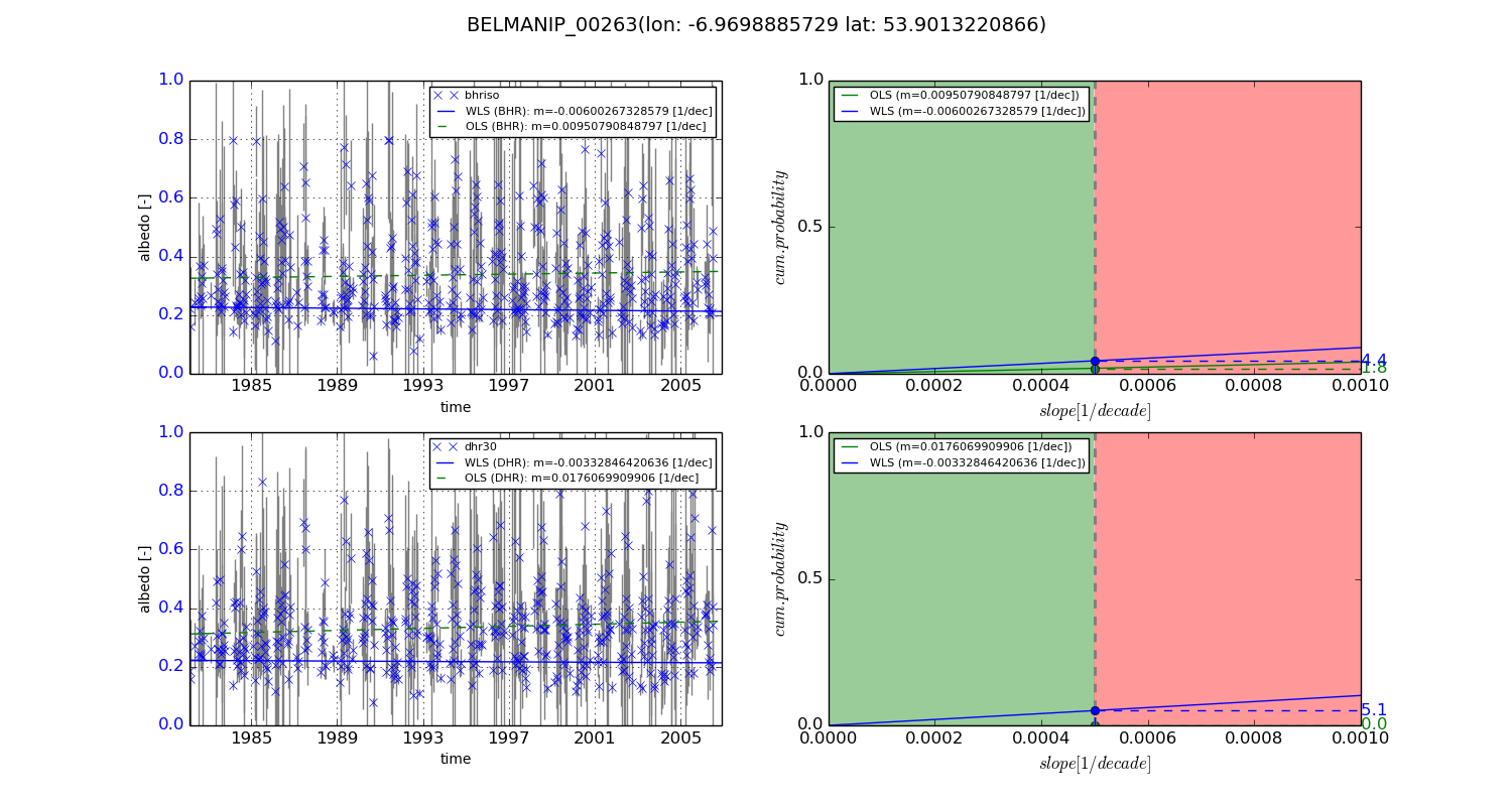
Temporal stability analysis

+000 deg (BHR)


BHR statistics

Temporal stability [1/decade]:


abs

rel


Weighted least square:

-0.00600267328579


Ordinary least square:

0.00950790848797


Probabilities that GCOS criteria is met:

Weighted least square:

4.4 %

Ordinary least square:

1.8 %


DHR statistics

Temporal stability [1/decade]:


abs

rel


Weighted least square:

-0.00332846420636


Ordinary least square:

0.0176069909906


Probabilities that GCOS criteria is met:

Weighted least square:

5.1 %

Ordinary least square:

0.0 %


+057/+063 deg (BHR)


BHR statistics

Temporal stability [1/decade]:


abs

rel


Weighted least square:

-99999.0


Ordinary least square:

-99999.0


Probabilities that GCOS criteria is met:

Weighted least square:

-99999.0 %

Ordinary least square:

-99999.0 %


DHR statistics

Temporal stability [1/decade]:


abs

rel


Weighted least square:

-99999.0


Ordinary least square:

-99999.0


Probabilities that GCOS criteria is met:

Weighted least square:

-99999.0 %

Ordinary least square:

-99999.0 %


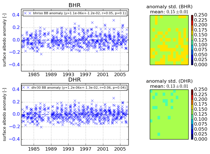
Temporal anomaly analyis

The variance of the temporal anomalies provides an additional measure about the stability of the signal AFTER removal of the mean seasonal cylce.
+000 deg


+057/+063 deg