BELMANIP_00282


Location

lon / lat [deg]: 117.2172 / -22.1756

Source network: BELMANIP


Geostationary surface albedo (GSA) data


“+000”


“+057/+063”


Landcover information (based on ESA CCI landcover data)


Landcover fractions @ 2km distance


Landcover fractions @ 20 km distance


Legend


Distance to open water bodies [km]:

none in region

Distance to urban areas [km]:

none in region


Radius: 1 km

Number of landcover classes:

2

Dominant landcover type:

130: grassland

Fraction of dominant landcover type [%]:

77.0


Radius: 2 km

Number of landcover classes:

2

Dominant landcover type:

120: Shrubland

Fraction of dominant landcover type [%]:

53.0


Radius: 5 km

Number of landcover classes:

2

Dominant landcover type:

120: Shrubland

Fraction of dominant landcover type [%]:

66.0


Radius: 10 km

Number of landcover classes:

2

Dominant landcover type:

120: Shrubland

Fraction of dominant landcover type [%]:

72.0


Radius: 20 km

Number of landcover classes:

2

Dominant landcover type:

120: Shrubland

Fraction of dominant landcover type [%]:

74.0


Disturbances


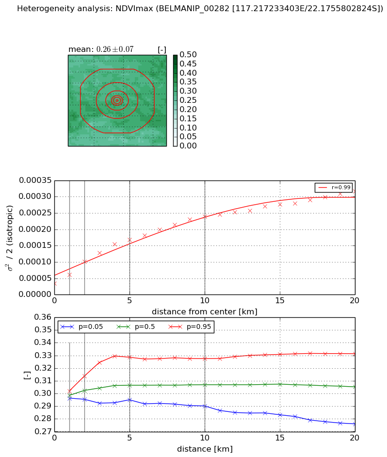
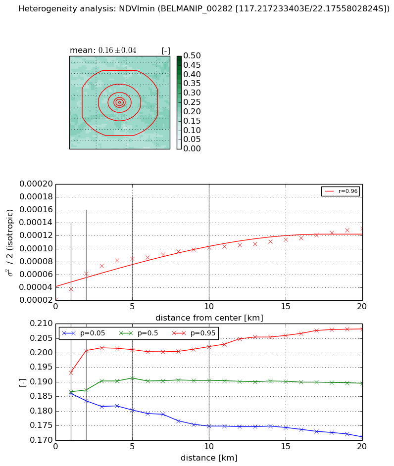
Heterogeneity analysis

The heterogeneity analysis provides information about the spatial and temporal heterogeneity of the site.

Topography


Roman et al. (2009) index


St

11.0038780917

Rcv

0.0377044971192

Rse

0.0

Rst

-0.112443487656

Rsv

-0.122483170806


Height range @ 1km [m]

35

Height range @ 2km [m]

144

Height range @ 5km [m]

176

Height range @ 10km [m]

-999

Height range @ 20km [m]

-999


Variance slope @ 1 km

1385

Variance slope @ 2 km

1033

Variance slope @ 5 km

644

Variance slope @ 10 km

-999

Variance slope @ 20 km

-999


NDVI (max. NDVI composite)


Roman et al. (2009) index


St

2.05264623852e-07

Rcv

0.0444883909444

Rse

0.0

Rst

0.101404780131

Rsv

14615280.0894


NDVI range @ 1km [-]

0.01

NDVI range @ 2km [-]

0.02

NDVI range @ 5km [-]

0.03

NDVI range @ 10km [-]

0.04

NDVI range @ 20km [-]

0.06


Variance slope @ 1 km

2.66283987241e-05

Variance slope @ 2 km

3.35165186127e-05

Variance slope @ 5 km

2.77083263596e-05

Variance slope @ 10 km

2.00784361357e-05

Variance slope @ 20 km

1.25952222024e-05


NDVI (min. NDVI composite)I


Roman et al. (2009) index


St

8.84119363566

Rcv

-0.000115969833957

Rse

0.0

Rst

-0.188824276135

Rsv

-0.150380452528


NDVI range @ 1km [-]

0.01

NDVI range @ 2km [-]

0.02

NDVI range @ 5km [-]

0.02

NDVI range @ 10km [-]

0.03

NDVI range @ 20km [-]

0.04


NDVI slope @ 1 km

1.61479631389e-05

NDVI slope @ 2 km

2.01348651946e-05

NDVI slope @ 5 km

1.32288955732e-05

NDVI slope @ 10 km

7.19801413682e-06

NDVI slope @ 20 km

4.27309239765e-06


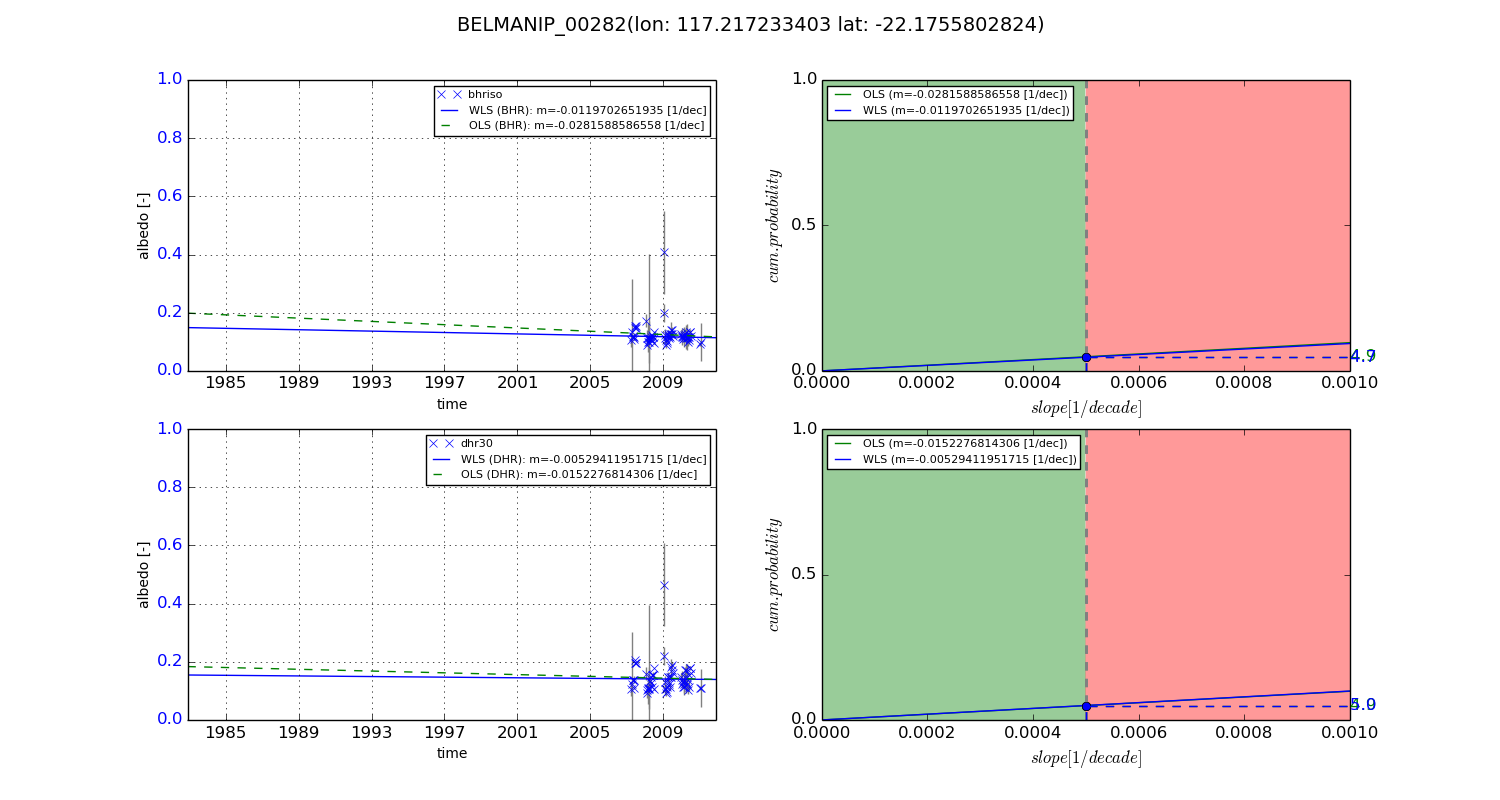
Temporal stability analysis

+000 deg (BHR)


BHR statistics

Temporal stability [1/decade]:


abs

rel


Weighted least square:

None


Ordinary least square:

None


Probabilities that GCOS criteria is met:

Weighted least square:

None %

Ordinary least square:

None %


DHR statistics

Temporal stability [1/decade]:


abs

rel


Weighted least square:

None


Ordinary least square:

None


Probabilities that GCOS criteria is met:

Weighted least square:

None %

Ordinary least square:

None %


+057/+063 deg (BHR)


BHR statistics

Temporal stability [1/decade]:


abs

rel


Weighted least square:

-0.0119702651935


Ordinary least square:

-0.0281588586558


Probabilities that GCOS criteria is met:

Weighted least square:

4.7 %

Ordinary least square:

4.9 %


DHR statistics

Temporal stability [1/decade]:


abs

rel


Weighted least square:

-0.00529411951715


Ordinary least square:

-0.0152276814306


Probabilities that GCOS criteria is met:

Weighted least square:

5.0 %

Ordinary least square:

4.9 %


Temporal anomaly analyis

The variance of the temporal anomalies provides an additional measure about the stability of the signal AFTER removal of the mean seasonal cylce.

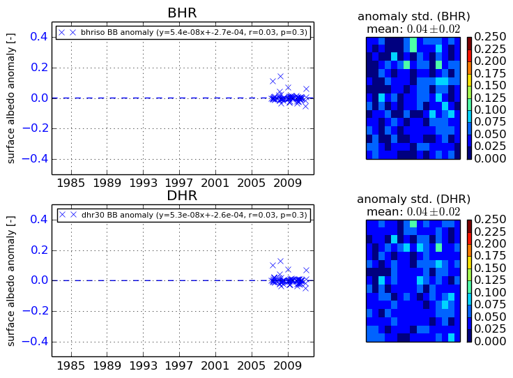
+000 deg


+057/+063 deg