BELMANIP_00288


Location

lon / lat [deg]: 115.9066 / -25.361

Source network: BELMANIP


Geostationary surface albedo (GSA) data


“+000”


“+057/+063”


Landcover information (based on ESA CCI landcover data)


Landcover fractions @ 2km distance


Landcover fractions @ 20 km distance


Legend


Distance to open water bodies [km]:

59.9

Distance to urban areas [km]:

none in region


Radius: 1 km

Number of landcover classes:

2

Dominant landcover type:

150: Sparse vegetation (tree, shrub, herbaceous cover) (<15%)

Fraction of dominant landcover type [%]:

95.0


Radius: 2 km

Number of landcover classes:

2

Dominant landcover type:

150: Sparse vegetation (tree, shrub, herbaceous cover) (<15%)

Fraction of dominant landcover type [%]:

96.0


Radius: 5 km

Number of landcover classes:

3

Dominant landcover type:

150: Sparse vegetation (tree, shrub, herbaceous cover) (<15%)

Fraction of dominant landcover type [%]:

95.0


Radius: 10 km

Number of landcover classes:

3

Dominant landcover type:

150: Sparse vegetation (tree, shrub, herbaceous cover) (<15%)

Fraction of dominant landcover type [%]:

97.0


Radius: 20 km

Number of landcover classes:

3

Dominant landcover type:

150: Sparse vegetation (tree, shrub, herbaceous cover) (<15%)

Fraction of dominant landcover type [%]:

92.0


Disturbances


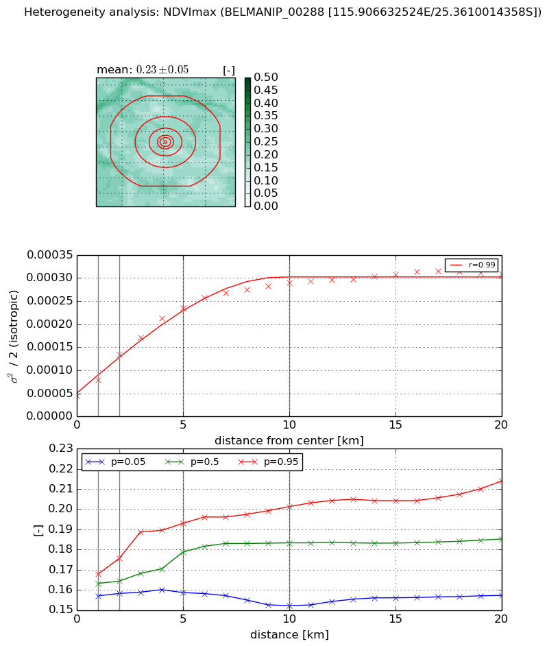
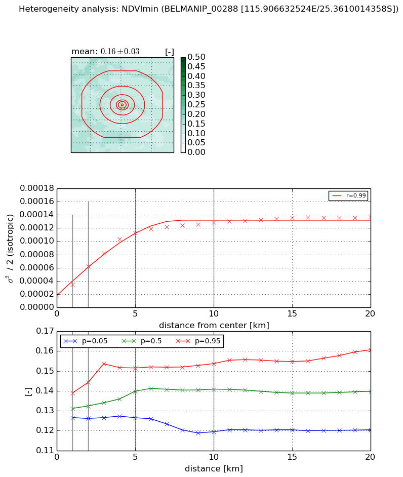
Heterogeneity analysis

The heterogeneity analysis provides information about the spatial and temporal heterogeneity of the site.

Topography


Roman et al. (2009) index


St

22.1936872984

Rcv

0.0849995945987

Rse

0.0

Rst

-0.0236813784758

Rsv

0.0264925994673


Height range @ 1km [m]

18

Height range @ 2km [m]

23

Height range @ 5km [m]

30

Height range @ 10km [m]

-999

Height range @ 20km [m]

-999


Variance slope @ 1 km

23

Variance slope @ 2 km

27

Variance slope @ 5 km

22

Variance slope @ 10 km

-999

Variance slope @ 20 km

-999


NDVI (max. NDVI composite)


Roman et al. (2009) index


St

6.39231625099

Rcv

0.0979855946173

Rse

0.0

Rst

-0.101270835393

Rsv

0.270057021047


NDVI range @ 1km [-]

0.01

NDVI range @ 2km [-]

0.02

NDVI range @ 5km [-]

0.03

NDVI range @ 10km [-]

0.05

NDVI range @ 20km [-]

0.06


Variance slope @ 1 km

3.46984490369e-05

Variance slope @ 2 km

4.47767824361e-05

Variance slope @ 5 km

3.96530865592e-05

Variance slope @ 10 km

2.45661436971e-05

Variance slope @ 20 km

1.1030128595e-05


NDVI (min. NDVI composite)I


Roman et al. (2009) index


St

11.2072876991

Rcv

-0.0552000116651

Rse

0.0

Rst

0.0661967360034

Rsv

-0.146286217251


NDVI range @ 1km [-]

0.01

NDVI range @ 2km [-]

0.02

NDVI range @ 5km [-]

0.03

NDVI range @ 10km [-]

0.03

NDVI range @ 20km [-]

0.04


NDVI slope @ 1 km

1.61303288746e-05

NDVI slope @ 2 km

2.17256327899e-05

NDVI slope @ 5 km

1.98374255063e-05

NDVI slope @ 10 km

1.08668751919e-05

NDVI slope @ 20 km

4.49652683766e-06


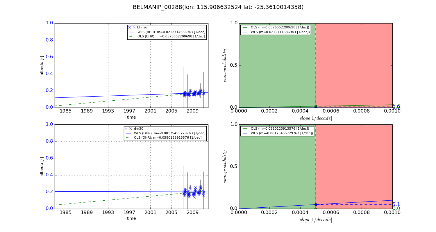
Temporal stability analysis

+000 deg (BHR)


BHR statistics

Temporal stability [1/decade]:


abs

rel


Weighted least square:

None


Ordinary least square:

None


Probabilities that GCOS criteria is met:

Weighted least square:

None %

Ordinary least square:

None %


DHR statistics

Temporal stability [1/decade]:


abs

rel


Weighted least square:

None


Ordinary least square:

None


Probabilities that GCOS criteria is met:

Weighted least square:

None %

Ordinary least square:

None %


+057/+063 deg (BHR)


BHR statistics

Temporal stability [1/decade]:


abs

rel


Weighted least square:

0.0212714686943


Ordinary least square:

0.0576552290698


Probabilities that GCOS criteria is met:

Weighted least square:

0.0 %

Ordinary least square:

1.6 %


DHR statistics

Temporal stability [1/decade]:


abs

rel


Weighted least square:

-0.00175455729763


Ordinary least square:

0.0580123913576


Probabilities that GCOS criteria is met:

Weighted least square:

5.1 %

Ordinary least square:

0.0 %


Temporal anomaly analyis

The variance of the temporal anomalies provides an additional measure about the stability of the signal AFTER removal of the mean seasonal cylce.

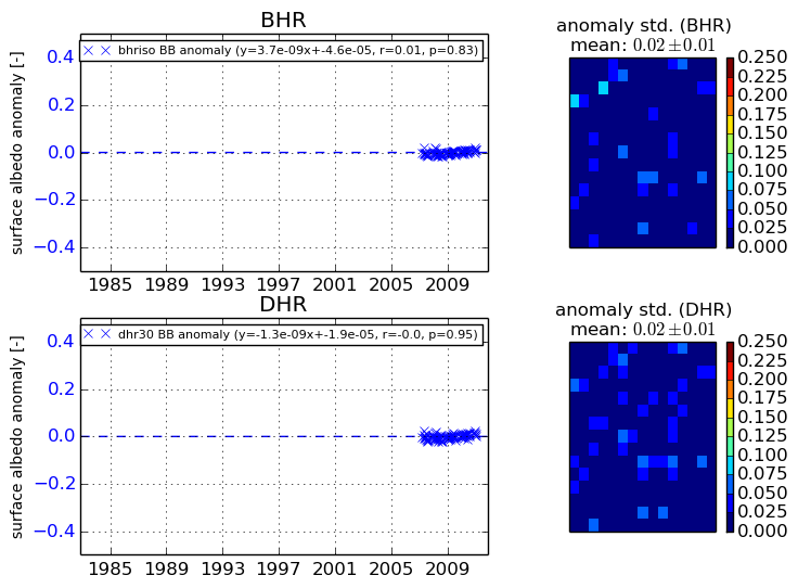
+000 deg


+057/+063 deg