BELMANIP_00331


Location

lon / lat [deg]: 104.316 / 27.0458

Source network: BELMANIP


Geostationary surface albedo (GSA) data


“+000”


“+057/+063”


Landcover information (based on ESA CCI landcover data)


Landcover fractions @ 2km distance


Landcover fractions @ 20 km distance


Legend


Distance to open water bodies [km]:

4.35

Distance to urban areas [km]:

17.14


Radius: 1 km

Number of landcover classes:

4

Dominant landcover type:

70: Tree cover, needleleaved, evergreen, closed to open (>15%)

Fraction of dominant landcover type [%]:

72.0


Radius: 2 km

Number of landcover classes:

4

Dominant landcover type:

70: Tree cover, needleleaved, evergreen, closed to open (>15%)

Fraction of dominant landcover type [%]:

51.0


Radius: 5 km

Number of landcover classes:

6

Dominant landcover type:

60: Tree cover, broadleaved, decidous

Fraction of dominant landcover type [%]:

51.0


Radius: 10 km

Number of landcover classes:

5

Dominant landcover type:

60: Tree cover, broadleaved, decidous

Fraction of dominant landcover type [%]:

46.0


Radius: 20 km

Number of landcover classes:

7

Dominant landcover type:

60: Tree cover, broadleaved, decidous

Fraction of dominant landcover type [%]:

45.0


Disturbances


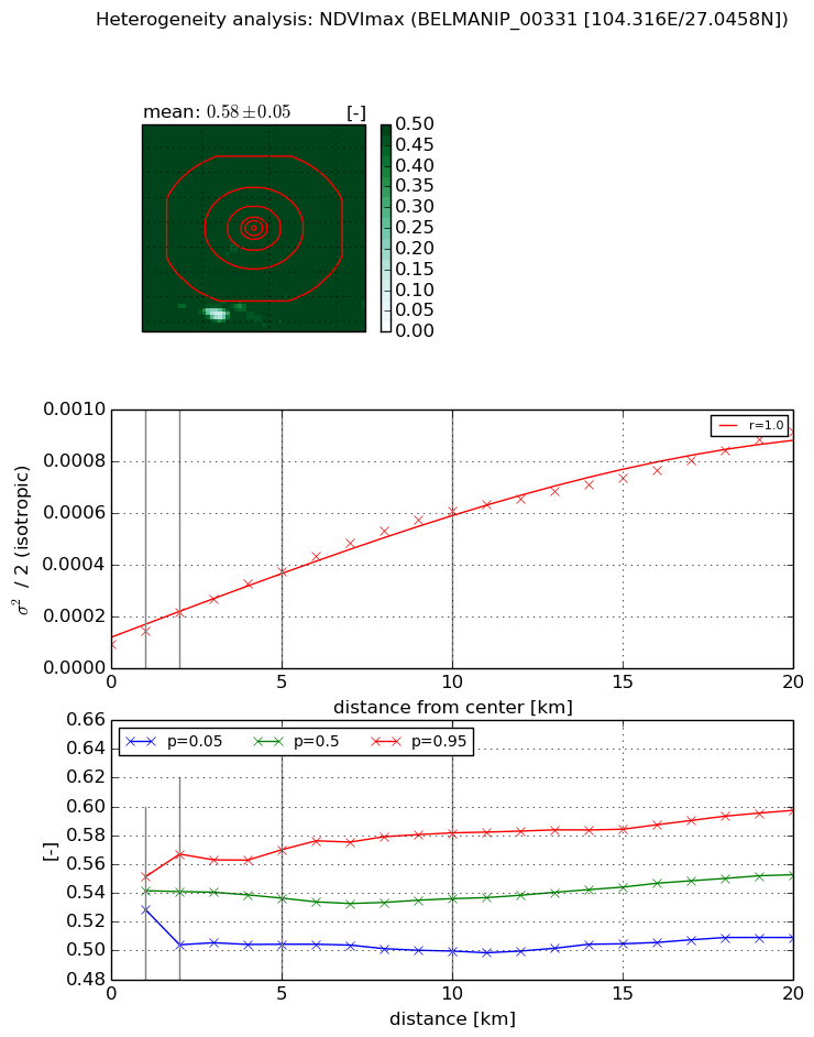
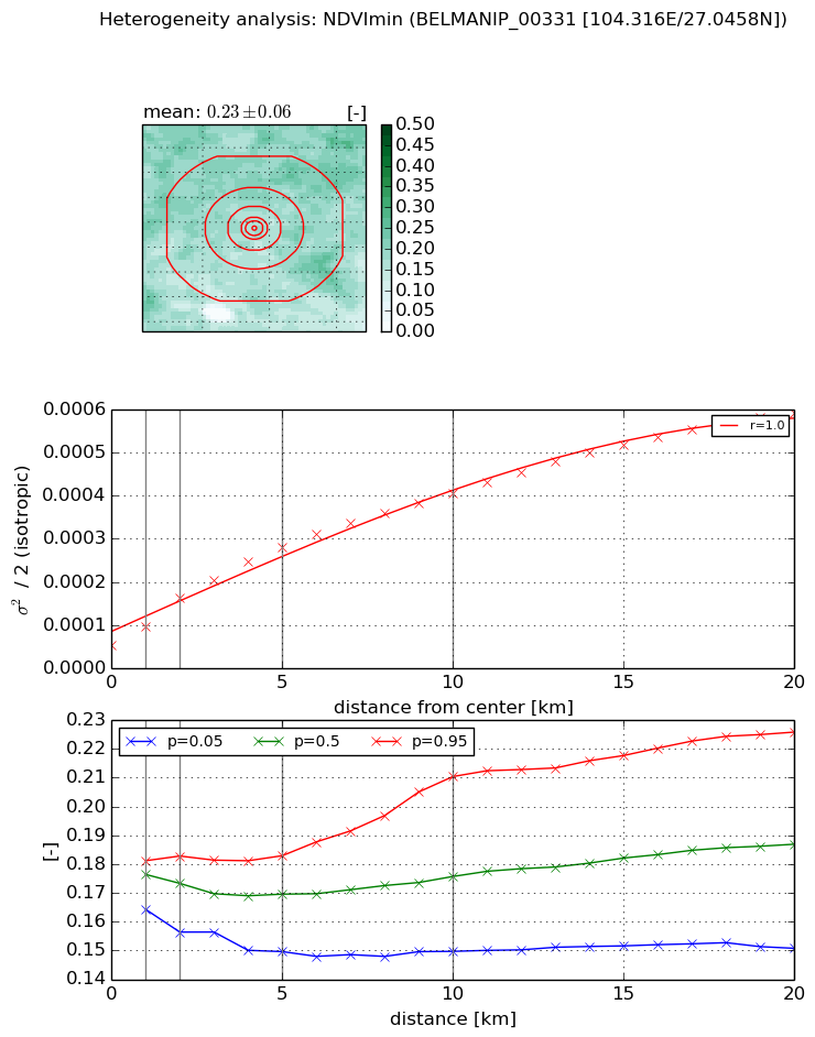
Heterogeneity analysis

The heterogeneity analysis provides information about the spatial and temporal heterogeneity of the site.

Topography


Roman et al. (2009) index


St

2.48320562247

Rcv

0.223537201443

Rse

0.0

Rst

-2.70895827124e-07

Rsv

-0.984578348939


Height range @ 1km [m]

203

Height range @ 2km [m]

216

Height range @ 5km [m]

313

Height range @ 10km [m]

-999

Height range @ 20km [m]

-999


Variance slope @ 1 km

2301

Variance slope @ 2 km

1854

Variance slope @ 5 km

1688

Variance slope @ 10 km

-999

Variance slope @ 20 km

-999


NDVI (max. NDVI composite)


Roman et al. (2009) index


St

1.04370448046

Rcv

0.0857551027072

Rse

0.0

Rst

-0.494047408394

Rsv

2.2945743419


NDVI range @ 1km [-]

0.02

NDVI range @ 2km [-]

0.06

NDVI range @ 5km [-]

0.07

NDVI range @ 10km [-]

0.08

NDVI range @ 20km [-]

0.09


Variance slope @ 1 km

4.81252372504e-05

Variance slope @ 2 km

6.20060718066e-05

Variance slope @ 5 km

5.73864836534e-05

Variance slope @ 10 km

5.25720459833e-05

Variance slope @ 20 km

3.90187659494e-05


NDVI (min. NDVI composite)I


Roman et al. (2009) index


St

0.425364822577

Rcv

0.396647965801

Rse

0.0

Rst

-0.615297951541

Rsv

6.04082347206


NDVI range @ 1km [-]

0.02

NDVI range @ 2km [-]

0.03

NDVI range @ 5km [-]

0.03

NDVI range @ 10km [-]

0.06

NDVI range @ 20km [-]

0.08


NDVI slope @ 1 km

4.23468172439e-05

NDVI slope @ 2 km

5.41418448672e-05

NDVI slope @ 5 km

4.631163007e-05

NDVI slope @ 10 km

3.47074681841e-05

NDVI slope @ 20 km

2.56086360776e-05


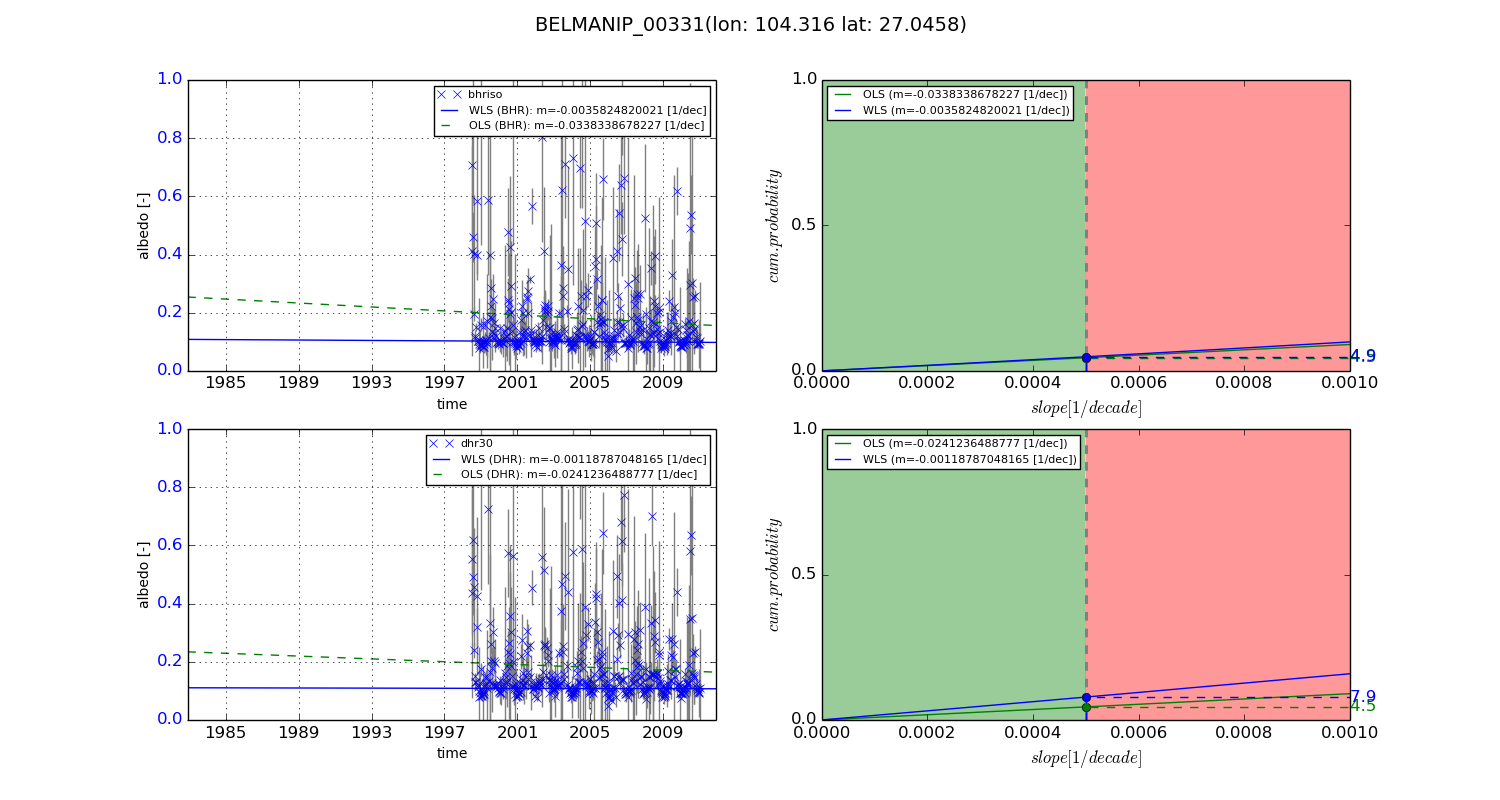
Temporal stability analysis

+000 deg (BHR)


BHR statistics

Temporal stability [1/decade]:


abs

rel


Weighted least square:

None


Ordinary least square:

None


Probabilities that GCOS criteria is met:

Weighted least square:

None %

Ordinary least square:

None %


DHR statistics

Temporal stability [1/decade]:


abs

rel


Weighted least square:

None


Ordinary least square:

None


Probabilities that GCOS criteria is met:

Weighted least square:

None %

Ordinary least square:

None %


+057/+063 deg (BHR)


BHR statistics

Temporal stability [1/decade]:


abs

rel


Weighted least square:

-0.0035824820021


Ordinary least square:

-0.0338338678227


Probabilities that GCOS criteria is met:

Weighted least square:

4.9 %

Ordinary least square:

4.5 %


DHR statistics

Temporal stability [1/decade]:


abs

rel


Weighted least square:

-0.00118787048165


Ordinary least square:

-0.0241236488777


Probabilities that GCOS criteria is met:

Weighted least square:

7.9 %

Ordinary least square:

4.5 %


Temporal anomaly analyis

The variance of the temporal anomalies provides an additional measure about the stability of the signal AFTER removal of the mean seasonal cylce.

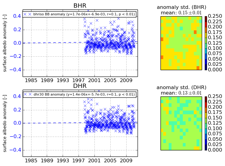
+000 deg


+057/+063 deg