BELMANIP_00396


Location

lon / lat [deg]: 105.5226 / 57.0364

Source network: BELMANIP


Geostationary surface albedo (GSA) data


“+000”


“+057/+063”


Landcover information (based on ESA CCI landcover data)


Landcover fractions @ 2km distance


Landcover fractions @ 20 km distance


Legend


Distance to open water bodies [km]:

27.49

Distance to urban areas [km]:

26.04


Radius: 1 km

Number of landcover classes:

2

Dominant landcover type:

70: Tree cover, needleleaved, evergreen, closed to open (>15%)

Fraction of dominant landcover type [%]:

90.0


Radius: 2 km

Number of landcover classes:

2

Dominant landcover type:

70: Tree cover, needleleaved, evergreen, closed to open (>15%)

Fraction of dominant landcover type [%]:

60.0


Radius: 5 km

Number of landcover classes:

4

Dominant landcover type:

90: Tree cover, mixed leaf type

Fraction of dominant landcover type [%]:

60.0


Radius: 10 km

Number of landcover classes:

4

Dominant landcover type:

90: Tree cover, mixed leaf type

Fraction of dominant landcover type [%]:

71.0


Radius: 20 km

Number of landcover classes:

5

Dominant landcover type:

90: Tree cover, mixed leaf type

Fraction of dominant landcover type [%]:

68.0


Disturbances


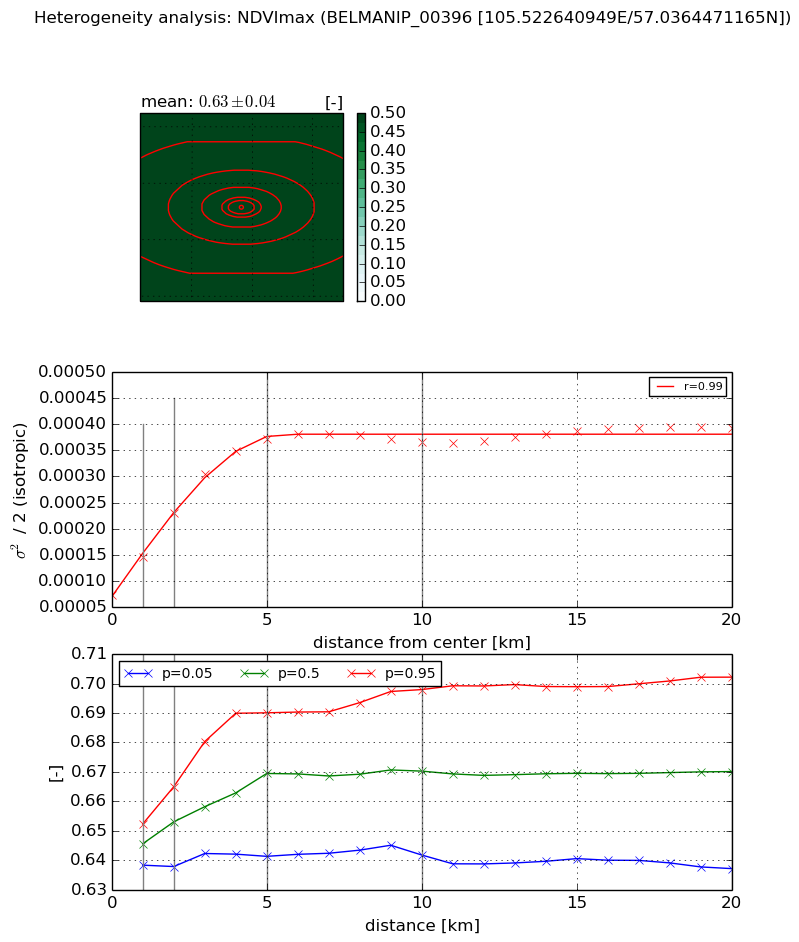
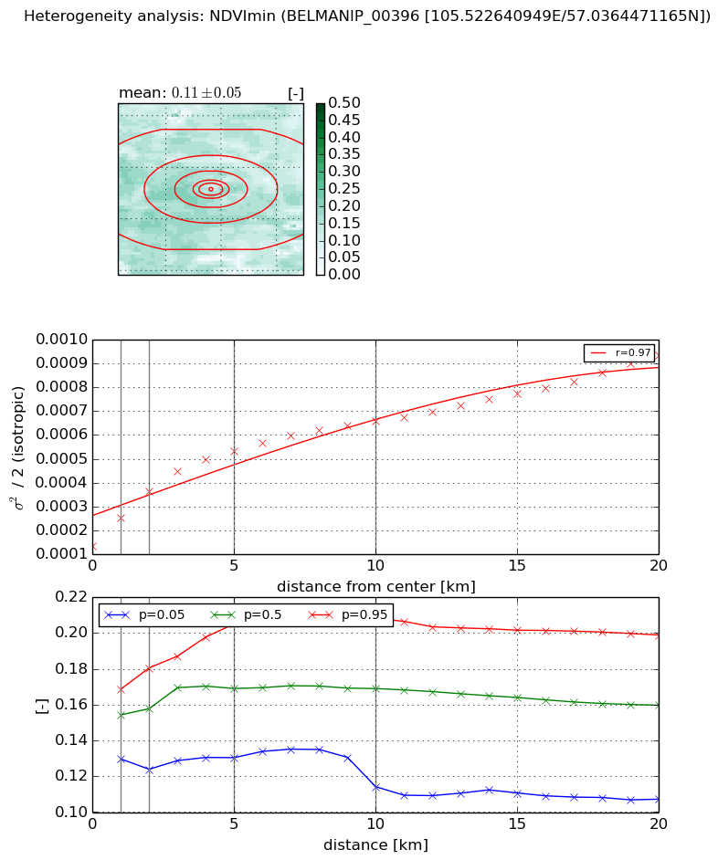
Heterogeneity analysis

The heterogeneity analysis provides information about the spatial and temporal heterogeneity of the site.

Topography


Roman et al. (2009) index


St

4.68541687739

Rcv

0.144434985432

Rse

0.0

Rst

-0.05363994985

Rsv

0.442209606842


Height range @ 1km [m]

97

Height range @ 2km [m]

122

Height range @ 5km [m]

133

Height range @ 10km [m]

-999

Height range @ 20km [m]

-999


Variance slope @ 1 km

598

Variance slope @ 2 km

591

Variance slope @ 5 km

412

Variance slope @ 10 km

-999

Variance slope @ 20 km

-999


NDVI (max. NDVI composite)


Roman et al. (2009) index


St

6.00439586535

Rcv

0.302772342636

Rse

0.0

Rst

-0.0817891684307

Rsv

0.115072435008


NDVI range @ 1km [-]

0.01

NDVI range @ 2km [-]

0.03

NDVI range @ 5km [-]

0.05

NDVI range @ 10km [-]

0.06

NDVI range @ 20km [-]

0.07


Variance slope @ 1 km

7.29625579389e-05

Variance slope @ 2 km

7.80625958722e-05

Variance slope @ 5 km

6.18538262483e-05

Variance slope @ 10 km

2.72544211641e-05

Variance slope @ 20 km

9.90206410434e-06


NDVI (min. NDVI composite)I


Roman et al. (2009) index


St

nan

Rcv

nan

Rse

nan

Rst

nan

Rsv

nan


NDVI range @ 1km [-]

0.04

NDVI range @ 2km [-]

0.06

NDVI range @ 5km [-]

0.07

NDVI range @ 10km [-]

0.09

NDVI range @ 20km [-]

0.09


NDVI slope @ 1 km

0.000118797895226

NDVI slope @ 2 km

0.000115564530495

NDVI slope @ 5 km

8.01403270657e-05

NDVI slope @ 10 km

4.8150321174e-05

NDVI slope @ 20 km

3.20611747603e-05


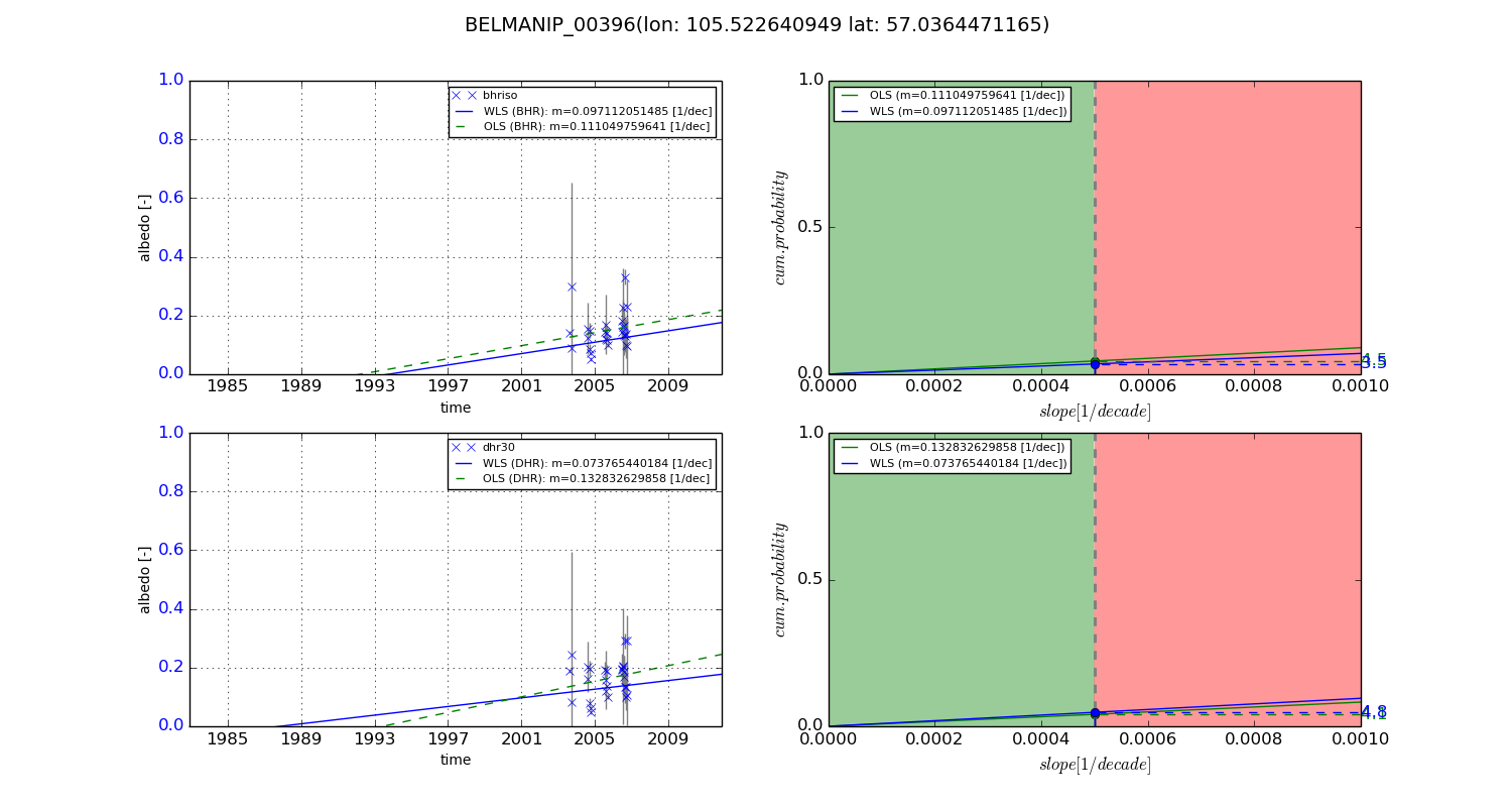
Temporal stability analysis

+000 deg (BHR)


BHR statistics

Temporal stability [1/decade]:


abs

rel


Weighted least square:

None


Ordinary least square:

None


Probabilities that GCOS criteria is met:

Weighted least square:

None %

Ordinary least square:

None %


DHR statistics

Temporal stability [1/decade]:


abs

rel


Weighted least square:

None


Ordinary least square:

None


Probabilities that GCOS criteria is met:

Weighted least square:

None %

Ordinary least square:

None %


+057/+063 deg (BHR)


BHR statistics

Temporal stability [1/decade]:


abs

rel


Weighted least square:

0.097112051485


Ordinary least square:

0.111049759641


Probabilities that GCOS criteria is met:

Weighted least square:

3.5 %

Ordinary least square:

4.5 %


DHR statistics

Temporal stability [1/decade]:


abs

rel


Weighted least square:

0.073765440184


Ordinary least square:

0.132832629858


Probabilities that GCOS criteria is met:

Weighted least square:

4.8 %

Ordinary least square:

4.1 %


Temporal anomaly analyis

The variance of the temporal anomalies provides an additional measure about the stability of the signal AFTER removal of the mean seasonal cylce.

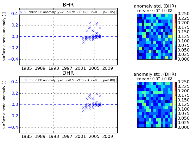
+000 deg


+057/+063 deg