BOU


Location

lon / lat [deg]: -105.007 / 40.05

Source network: BSRN


Geostationary surface albedo (GSA) data


“+000”


“+057/+063”


Landcover information (based on ESA CCI landcover data)


Landcover fractions @ 2km distance


Landcover fractions @ 20 km distance


Legend


Distance to open water bodies [km]:

5.42

Distance to urban areas [km]:

2.72


Radius: 1 km

Number of landcover classes:

3

Dominant landcover type:

130: grassland

Fraction of dominant landcover type [%]:

93.0


Radius: 2 km

Number of landcover classes:

3

Dominant landcover type:

130: grassland

Fraction of dominant landcover type [%]:

84.0


Radius: 5 km

Number of landcover classes:

3

Dominant landcover type:

130: grassland

Fraction of dominant landcover type [%]:

87.0


Radius: 10 km

Number of landcover classes:

5

Dominant landcover type:

130: grassland

Fraction of dominant landcover type [%]:

71.0


Radius: 20 km

Number of landcover classes:

6

Dominant landcover type:

130: grassland

Fraction of dominant landcover type [%]:

56.0


Disturbances


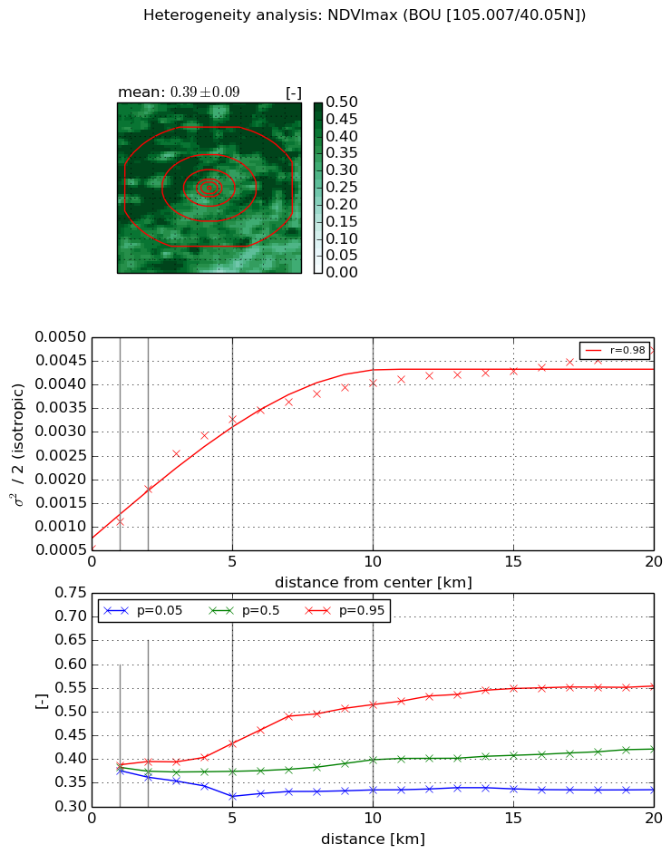
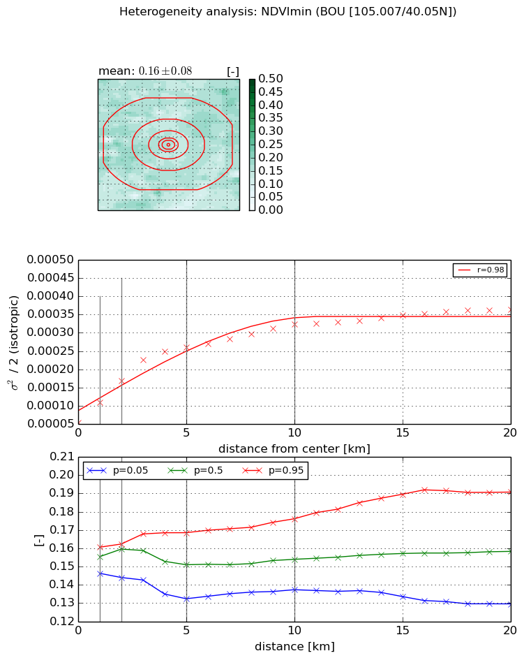
Heterogeneity analysis

The heterogeneity analysis provides information about the spatial and temporal heterogeneity of the site.

Topography


Roman et al. (2009) index


St

0.0150992099912

Rcv

0.315669419623

Rse

0.0

Rst

0.000304225587306

Rsv

198.369917984


Height range @ 1km [m]

26

Height range @ 2km [m]

46

Height range @ 5km [m]

79

Height range @ 10km [m]

-999

Height range @ 20km [m]

-999


Variance slope @ 1 km

90

Variance slope @ 2 km

113

Variance slope @ 5 km

153

Variance slope @ 10 km

-999

Variance slope @ 20 km

-999


NDVI (max. NDVI composite)


Roman et al. (2009) index


St

1.12849063568

Rcv

1.0398520705

Rse

0.0

Rst

-0.349541621717

Rsv

1.26902446841


NDVI range @ 1km [-]

0.01

NDVI range @ 2km [-]

0.03

NDVI range @ 5km [-]

0.11

NDVI range @ 10km [-]

0.18

NDVI range @ 20km [-]

0.22


Variance slope @ 1 km

0.000583777516921

Variance slope @ 2 km

0.000631048680584

Variance slope @ 5 km

0.000566999376992

Variance slope @ 10 km

0.000341032887875

Variance slope @ 20 km

0.000165863616632


NDVI (min. NDVI composite)I


Roman et al. (2009) index


St

3.3814505648

Rcv

0.389253637279

Rse

0.0

Rst

0.00855983721578

Rsv

0.489379741112


NDVI range @ 1km [-]

0.01

NDVI range @ 2km [-]

0.02

NDVI range @ 5km [-]

0.04

NDVI range @ 10km [-]

0.04

NDVI range @ 20km [-]

0.06


NDVI slope @ 1 km

5.54524583854e-05

NDVI slope @ 2 km

5.75102370526e-05

NDVI slope @ 5 km

4.29449289442e-05

NDVI slope @ 10 km

2.43260653721e-05

NDVI slope @ 20 km

1.2237635986e-05


Temporal stability analysis

+000 deg (BHR)


BHR statistics

Temporal stability [1/decade]:


abs

rel


Weighted least square:

None


Ordinary least square:

None


Probabilities that GCOS criteria is met:

Weighted least square:

None %

Ordinary least square:

None %


DHR statistics

Temporal stability [1/decade]:


abs

rel


Weighted least square:

None


Ordinary least square:

None


Probabilities that GCOS criteria is met:

Weighted least square:

None %

Ordinary least square:

None %


+057/+063 deg (BHR)


BHR statistics

Temporal stability [1/decade]:


abs

rel


Weighted least square:

None


Ordinary least square:

None


Probabilities that GCOS criteria is met:

Weighted least square:

None %

Ordinary least square:

None %


DHR statistics

Temporal stability [1/decade]:


abs

rel


Weighted least square:

None


Ordinary least square:

None


Probabilities that GCOS criteria is met:

Weighted least square:

None %

Ordinary least square:

None %


Temporal anomaly analyis

The variance of the temporal anomalies provides an additional measure about the stability of the signal AFTER removal of the mean seasonal cylce.

+000 deg


+057/+063 deg