CN-KU2


Location

lon / lat [deg]: 108.549 / 40.3808

Source network: FLUXNET


Geostationary surface albedo (GSA) data


“+000”


“+057/+063”


Landcover information (based on ESA CCI landcover data)


Landcover fractions @ 2km distance


Landcover fractions @ 20 km distance


Legend


Distance to open water bodies [km]:

24.52

Distance to urban areas [km]:

32.84


Radius: 1 km

Number of landcover classes:

1

Dominant landcover type:

130: grassland

Fraction of dominant landcover type [%]:

100.0


Radius: 2 km

Number of landcover classes:

1

Dominant landcover type:

130: grassland

Fraction of dominant landcover type [%]:

100.0


Radius: 5 km

Number of landcover classes:

2

Dominant landcover type:

130: grassland

Fraction of dominant landcover type [%]:

86.0


Radius: 10 km

Number of landcover classes:

2

Dominant landcover type:

130: grassland

Fraction of dominant landcover type [%]:

72.0


Radius: 20 km

Number of landcover classes:

2

Dominant landcover type:

130: grassland

Fraction of dominant landcover type [%]:

52.0


Disturbances


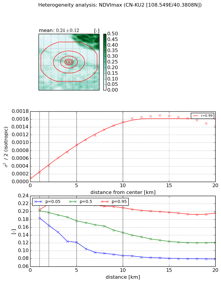
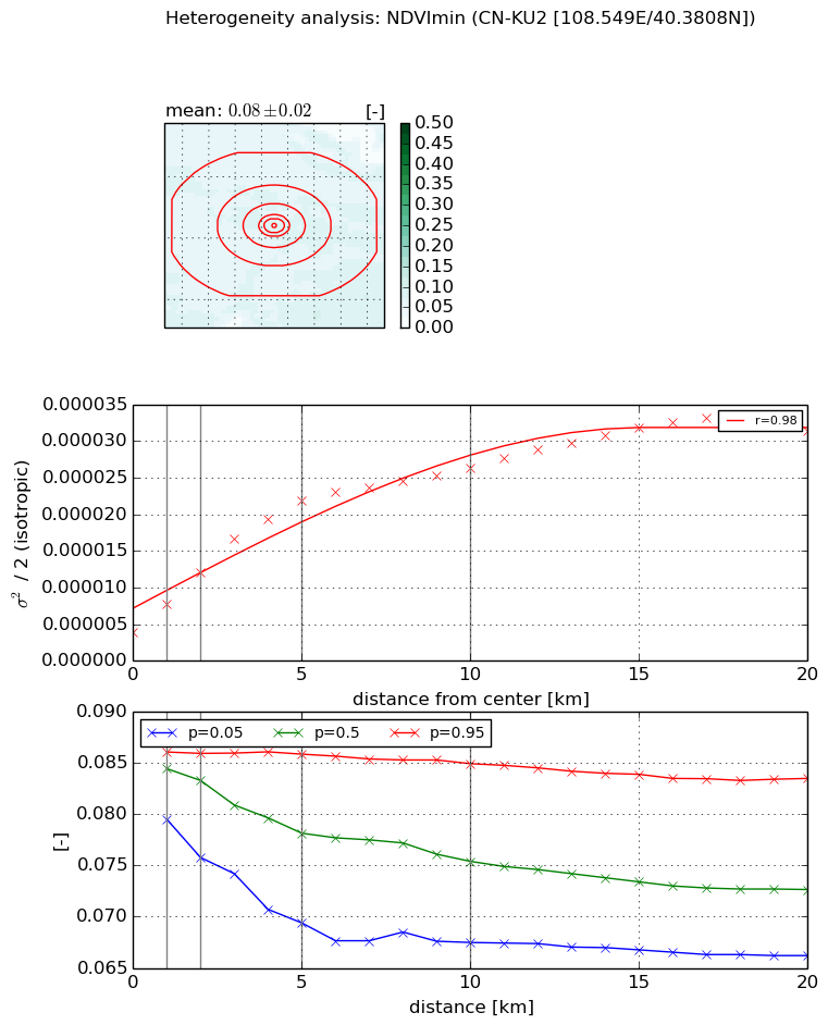
Heterogeneity analysis

The heterogeneity analysis provides information about the spatial and temporal heterogeneity of the site.

Topography


Roman et al. (2009) index


St

3.42117047564

Rcv

0.302928212836

Rse

0.0

Rst

-8.2231336096e-06

Rsv

-0.573956434865


Height range @ 1km [m]

48

Height range @ 2km [m]

62

Height range @ 5km [m]

110

Height range @ 10km [m]

-999

Height range @ 20km [m]

-999


Variance slope @ 1 km

174

Variance slope @ 2 km

194

Variance slope @ 5 km

244

Variance slope @ 10 km

-999

Variance slope @ 20 km

-999


NDVI (max. NDVI composite)


Roman et al. (2009) index


St

1.9357373108

Rcv

0.579437731388

Rse

0.0

Rst

0.141066374961

Rsv

0.829292957158


NDVI range @ 1km [-]

0.02

NDVI range @ 2km [-]

0.05

NDVI range @ 5km [-]

0.1

NDVI range @ 10km [-]

0.12

NDVI range @ 20km [-]

0.12


Variance slope @ 1 km

0.000126002008569

Variance slope @ 2 km

0.000144371949651

Variance slope @ 5 km

0.000168102971548

Variance slope @ 10 km

0.000146491490756

Variance slope @ 20 km

7.10955058372e-05


NDVI (min. NDVI composite)I


Roman et al. (2009) index


St

3.265328634

Rcv

0.3921541837

Rse

0.0

Rst

-0.081123284498

Rsv

0.445466197835


NDVI range @ 1km [-]

0.01

NDVI range @ 2km [-]

0.01

NDVI range @ 5km [-]

0.02

NDVI range @ 10km [-]

0.02

NDVI range @ 20km [-]

0.02


NDVI slope @ 1 km

3.90109908578e-06

NDVI slope @ 2 km

4.13095804734e-06

NDVI slope @ 5 km

3.70183441173e-06

NDVI slope @ 10 km

2.15905819571e-06

NDVI slope @ 20 km

1.2601077105e-06


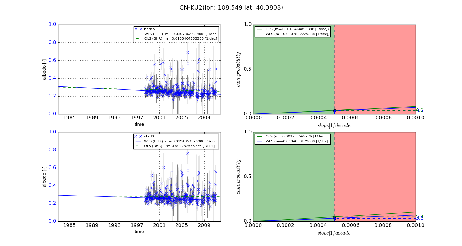
Temporal stability analysis

+000 deg (BHR)


BHR statistics

Temporal stability [1/decade]:


abs

rel


Weighted least square:

None


Ordinary least square:

None


Probabilities that GCOS criteria is met:

Weighted least square:

None %

Ordinary least square:

None %


DHR statistics

Temporal stability [1/decade]:


abs

rel


Weighted least square:

None


Ordinary least square:

None


Probabilities that GCOS criteria is met:

Weighted least square:

None %

Ordinary least square:

None %


+057/+063 deg (BHR)


BHR statistics

Temporal stability [1/decade]:


abs

rel


Weighted least square:

-0.0307862229888


Ordinary least square:

-0.0163464853388


Probabilities that GCOS criteria is met:

Weighted least square:

3.7 %

Ordinary least square:

4.2 %


DHR statistics

Temporal stability [1/decade]:


abs

rel


Weighted least square:

-0.0194853179888


Ordinary least square:

-0.002732565776


Probabilities that GCOS criteria is met:

Weighted least square:

3.5 %

Ordinary least square:

5.1 %


Temporal anomaly analyis

The variance of the temporal anomalies provides an additional measure about the stability of the signal AFTER removal of the mean seasonal cylce.

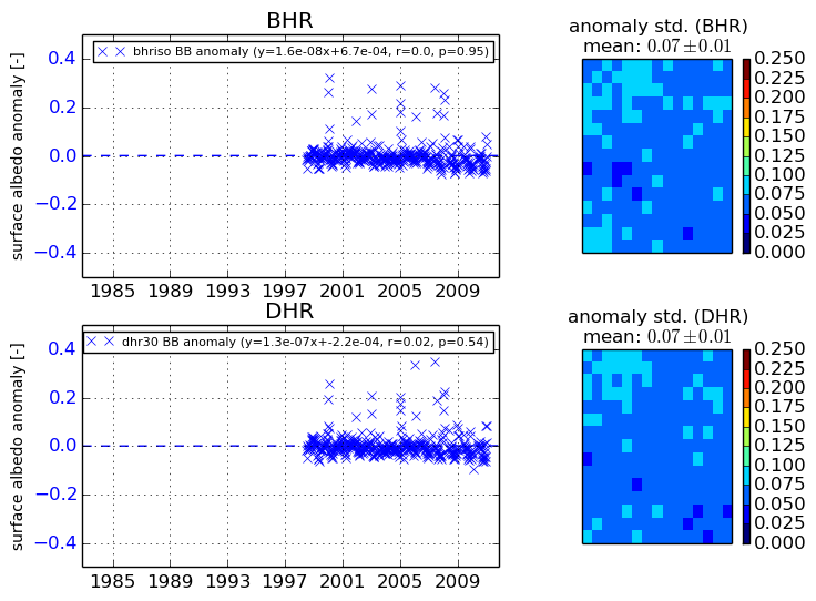
+000 deg


+057/+063 deg