FPE


Location

lon / lat [deg]: -105.1 / 48.3167

Source network: BSRN


Geostationary surface albedo (GSA) data


“+000”


“+057/+063”


Landcover information (based on ESA CCI landcover data)


Landcover fractions @ 2km distance


Landcover fractions @ 20 km distance


Legend


Distance to open water bodies [km]:

10.06

Distance to urban areas [km]:

23.5


Radius: 1 km

Number of landcover classes:

1

Dominant landcover type:

130: grassland

Fraction of dominant landcover type [%]:

100.0


Radius: 2 km

Number of landcover classes:

2

Dominant landcover type:

130: grassland

Fraction of dominant landcover type [%]:

96.0


Radius: 5 km

Number of landcover classes:

2

Dominant landcover type:

130: grassland

Fraction of dominant landcover type [%]:

78.0


Radius: 10 km

Number of landcover classes:

2

Dominant landcover type:

130: grassland

Fraction of dominant landcover type [%]:

65.0


Radius: 20 km

Number of landcover classes:

2

Dominant landcover type:

130: grassland

Fraction of dominant landcover type [%]:

65.0


Disturbances


Heterogeneity analysis

The heterogeneity analysis provides information about the spatial and temporal heterogeneity of the site.

Topography


Roman et al. (2009) index


St

1.90109921241

Rcv

0.649324347407

Rse

0.0

Rst

-0.013749273259

Rsv

0.914960803004


Height range @ 1km [m]

13

Height range @ 2km [m]

36

Height range @ 5km [m]

107

Height range @ 10km [m]

-999

Height range @ 20km [m]

-999


Variance slope @ 1 km

157

Variance slope @ 2 km

215

Variance slope @ 5 km

306

Variance slope @ 10 km

-999

Variance slope @ 20 km

-999


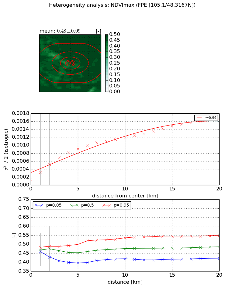
NDVI (max. NDVI composite)


Roman et al. (2009) index


St

12.859712071

Rcv

0.139790177278

Rse

0.0

Rst

-0.0127824922865

Rsv

0.0807140466097


NDVI range @ 1km [-]

0.02

NDVI range @ 2km [-]

0.06

NDVI range @ 5km [-]

0.1

NDVI range @ 10km [-]

0.12

NDVI range @ 20km [-]

0.13


Variance slope @ 1 km

0.000170806091515

Variance slope @ 2 km

0.000185877580129

Variance slope @ 5 km

0.000156170071289

Variance slope @ 10 km

0.000102631756863

Variance slope @ 20 km

6.78327982502e-05


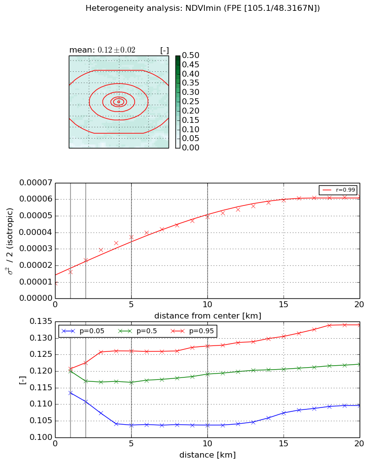
NDVI (min. NDVI composite)I


Roman et al. (2009) index


St

8.57076129544

Rcv

0.176415987216

Rse

0.0

Rst

0.061261169094

Rsv

-0.112350092914


NDVI range @ 1km [-]

0.01

NDVI range @ 2km [-]

0.01

NDVI range @ 5km [-]

0.02

NDVI range @ 10km [-]

0.02

NDVI range @ 20km [-]

0.02


NDVI slope @ 1 km

6.86910347966e-06

NDVI slope @ 2 km

7.0957856812e-06

NDVI slope @ 5 km

5.70871073765e-06

NDVI slope @ 10 km

3.80399841597e-06

NDVI slope @ 20 km

2.42991361789e-06


Temporal stability analysis

+000 deg (BHR)


BHR statistics

Temporal stability [1/decade]:


abs

rel


Weighted least square:

None


Ordinary least square:

None


Probabilities that GCOS criteria is met:

Weighted least square:

None %

Ordinary least square:

None %


DHR statistics

Temporal stability [1/decade]:


abs

rel


Weighted least square:

None


Ordinary least square:

None


Probabilities that GCOS criteria is met:

Weighted least square:

None %

Ordinary least square:

None %


+057/+063 deg (BHR)


BHR statistics

Temporal stability [1/decade]:


abs

rel


Weighted least square:

None


Ordinary least square:

None


Probabilities that GCOS criteria is met:

Weighted least square:

None %

Ordinary least square:

None %


DHR statistics

Temporal stability [1/decade]:


abs

rel


Weighted least square:

None


Ordinary least square:

None


Probabilities that GCOS criteria is met:

Weighted least square:

None %

Ordinary least square:

None %


Temporal anomaly analyis

The variance of the temporal anomalies provides an additional measure about the stability of the signal AFTER removal of the mean seasonal cylce.

+000 deg


+057/+063 deg