HAND_N_52208


Location

lon / lat [deg]: 80.5094 / 26.331

Source network: AERONET


Geostationary surface albedo (GSA) data


“+000”


“+057/+063”


Landcover information (based on ESA CCI landcover data)


Landcover fractions @ 2km distance


Landcover fractions @ 20 km distance


Legend


Distance to open water bodies [km]:

1.98

Distance to urban areas [km]:

3.73


Radius: 1 km

Number of landcover classes:

1

Dominant landcover type:

20: cropland, irrigated or post-flooded

Fraction of dominant landcover type [%]:

100.0


Radius: 2 km

Number of landcover classes:

3

Dominant landcover type:

20: cropland, irrigated or post-flooded

Fraction of dominant landcover type [%]:

97.0


Radius: 5 km

Number of landcover classes:

5

Dominant landcover type:

20: cropland, irrigated or post-flooded

Fraction of dominant landcover type [%]:

69.0


Radius: 10 km

Number of landcover classes:

2

Dominant landcover type:

20: cropland, irrigated or post-flooded

Fraction of dominant landcover type [%]:

66.0


Radius: 20 km

Number of landcover classes:

3

Dominant landcover type:

20: cropland, irrigated or post-flooded

Fraction of dominant landcover type [%]:

78.0


Disturbances


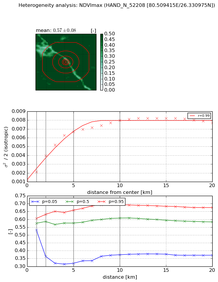
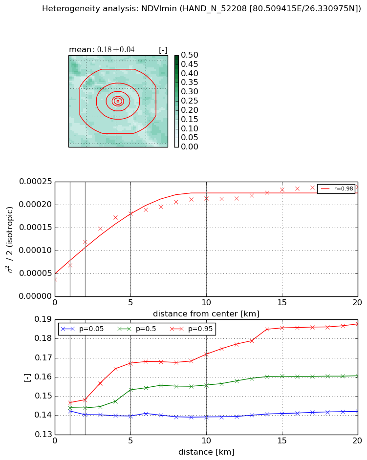
Heterogeneity analysis

The heterogeneity analysis provides information about the spatial and temporal heterogeneity of the site.

Topography


Roman et al. (2009) index


St

1.42940396124

Rcv

0.379132563136

Rse

0.0

Rst

2.15871031584e-09

Rsv

1.71964432447


Height range @ 1km [m]

5

Height range @ 2km [m]

6

Height range @ 5km [m]

16

Height range @ 10km [m]

-999

Height range @ 20km [m]

-999


Variance slope @ 1 km

4

Variance slope @ 2 km

4

Variance slope @ 5 km

4

Variance slope @ 10 km

-999

Variance slope @ 20 km

-999


NDVI (max. NDVI composite)


Roman et al. (2009) index


St

3.97662907962

Rcv

-0.0918096216677

Rse

0.0

Rst

0.129065934136

Rsv

-0.53353224536


NDVI range @ 1km [-]

0.07

NDVI range @ 2km [-]

0.27

NDVI range @ 5km [-]

0.34

NDVI range @ 10km [-]

0.32

NDVI range @ 20km [-]

0.3


Variance slope @ 1 km

0.00101809762428

Variance slope @ 2 km

0.00142748003989

Variance slope @ 5 km

0.00118605268314

Variance slope @ 10 km

0.000649973038477

Variance slope @ 20 km

0.000260604673783


NDVI (min. NDVI composite)I


Roman et al. (2009) index


St

3.15928323458

Rcv

0.441515722954

Rse

0.0

Rst

0.0421456442378

Rsv

-0.465921109987


NDVI range @ 1km [-]

0.0

NDVI range @ 2km [-]

0.01

NDVI range @ 5km [-]

0.03

NDVI range @ 10km [-]

0.03

NDVI range @ 20km [-]

0.05


NDVI slope @ 1 km

3.08393245818e-05

NDVI slope @ 2 km

4.07527019118e-05

NDVI slope @ 5 km

3.02262028084e-05

NDVI slope @ 10 km

1.66269744096e-05

NDVI slope @ 20 km

7.80334336937e-06


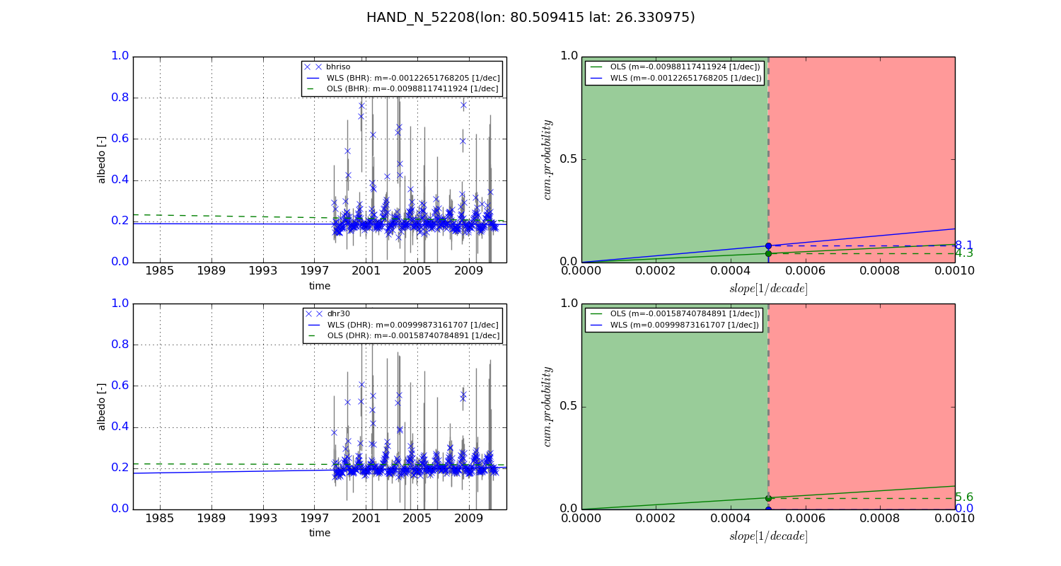
Temporal stability analysis

+000 deg (BHR)


BHR statistics

Temporal stability [1/decade]:


abs

rel


Weighted least square:

None


Ordinary least square:

None


Probabilities that GCOS criteria is met:

Weighted least square:

None %

Ordinary least square:

None %


DHR statistics

Temporal stability [1/decade]:


abs

rel


Weighted least square:

None


Ordinary least square:

None


Probabilities that GCOS criteria is met:

Weighted least square:

None %

Ordinary least square:

None %


+057/+063 deg (BHR)


BHR statistics

Temporal stability [1/decade]:


abs

rel


Weighted least square:

-0.00122651768205


Ordinary least square:

-0.00988117411924


Probabilities that GCOS criteria is met:

Weighted least square:

8.1 %

Ordinary least square:

4.3 %


DHR statistics

Temporal stability [1/decade]:


abs

rel


Weighted least square:

0.00999873161707


Ordinary least square:

-0.00158740784891


Probabilities that GCOS criteria is met:

Weighted least square:

0.0 %

Ordinary least square:

5.6 %


Temporal anomaly analyis

The variance of the temporal anomalies provides an additional measure about the stability of the signal AFTER removal of the mean seasonal cylce.

+000 deg


+057/+063 deg