IAOCA-KRSU


Location

lon / lat [deg]: 78.4644 / 42.4737

Source network: AERONET


Geostationary surface albedo (GSA) data


“+000”


“+057/+063”


Landcover information (based on ESA CCI landcover data)


Landcover fractions @ 2km distance


Landcover fractions @ 20 km distance


Legend


Distance to open water bodies [km]:

12.24

Distance to urban areas [km]:

1.23


Radius: 1 km

Number of landcover classes:

5

Dominant landcover type:

10: cropland, rainfed

Fraction of dominant landcover type [%]:

26.0


Radius: 2 km

Number of landcover classes:

6

Dominant landcover type:

20: cropland, irrigated or post-flooded

Fraction of dominant landcover type [%]:

23.0


Radius: 5 km

Number of landcover classes:

7

Dominant landcover type:

20: cropland, irrigated or post-flooded

Fraction of dominant landcover type [%]:

32.0


Radius: 10 km

Number of landcover classes:

9

Dominant landcover type:

20: cropland, irrigated or post-flooded

Fraction of dominant landcover type [%]:

35.0


Radius: 20 km

Number of landcover classes:

12

Dominant landcover type:

20: cropland, irrigated or post-flooded

Fraction of dominant landcover type [%]:

42.0


Disturbances


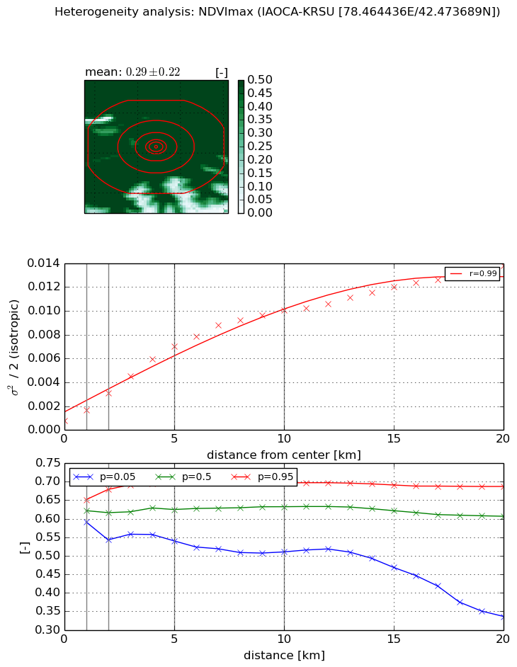
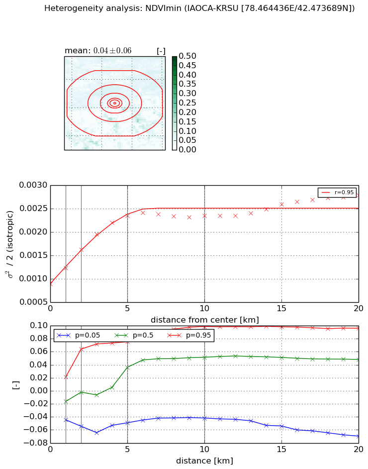
Heterogeneity analysis

The heterogeneity analysis provides information about the spatial and temporal heterogeneity of the site.

Topography


Roman et al. (2009) index


St

2.7499830206

Rcv

0.108408754421

Rse

0.0

Rst

-6.1900204107e-06

Rsv

-0.982500882139


Height range @ 1km [m]

322

Height range @ 2km [m]

570

Height range @ 5km [m]

740

Height range @ 10km [m]

-999

Height range @ 20km [m]

-999


Variance slope @ 1 km

5253

Variance slope @ 2 km

7921

Variance slope @ 5 km

13455

Variance slope @ 10 km

-999

Variance slope @ 20 km

-999


NDVI (max. NDVI composite)


Roman et al. (2009) index


St

7.00325551146

Rcv

0.0256110448903

Rse

0.0

Rst

-0.0337595585417

Rsv

0.369001600765


NDVI range @ 1km [-]

0.06

NDVI range @ 2km [-]

0.14

NDVI range @ 5km [-]

0.16

NDVI range @ 10km [-]

0.19

NDVI range @ 20km [-]

0.35


Variance slope @ 1 km

0.000877561625571

Variance slope @ 2 km

0.0011580202277

Variance slope @ 5 km

0.00130559284682

Variance slope @ 10 km

0.000975010124774

Variance slope @ 20 km

0.000597644348842


NDVI (min. NDVI composite)I


Roman et al. (2009) index


St

2.58677862027e-07

Rcv

-0.932393311402

Rse

0.0

Rst

0.362803419519

Rsv

11597434.9001


NDVI range @ 1km [-]

0.07

NDVI range @ 2km [-]

0.12

NDVI range @ 5km [-]

0.12

NDVI range @ 10km [-]

0.14

NDVI range @ 20km [-]

0.17


NDVI slope @ 1 km

0.000339804855606

NDVI slope @ 2 km

0.000368243887508

NDVI slope @ 5 km

0.000301157520521

NDVI slope @ 10 km

0.000134439261555

NDVI slope @ 20 km

6.59412921996e-05


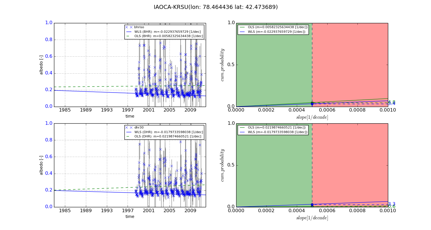
Temporal stability analysis

+000 deg (BHR)


BHR statistics

Temporal stability [1/decade]:


abs

rel


Weighted least square:

None


Ordinary least square:

None


Probabilities that GCOS criteria is met:

Weighted least square:

None %

Ordinary least square:

None %


DHR statistics

Temporal stability [1/decade]:


abs

rel


Weighted least square:

None


Ordinary least square:

None


Probabilities that GCOS criteria is met:

Weighted least square:

None %

Ordinary least square:

None %


+057/+063 deg (BHR)


BHR statistics

Temporal stability [1/decade]:


abs

rel


Weighted least square:

-0.022937659729


Ordinary least square:

0.00582325634438


Probabilities that GCOS criteria is met:

Weighted least square:

3.4 %

Ordinary least square:

4.8 %


DHR statistics

Temporal stability [1/decade]:


abs

rel


Weighted least square:

-0.0179733598038


Ordinary least square:

0.0219874660521


Probabilities that GCOS criteria is met:

Weighted least square:

3.3 %

Ordinary least square:

0.6 %


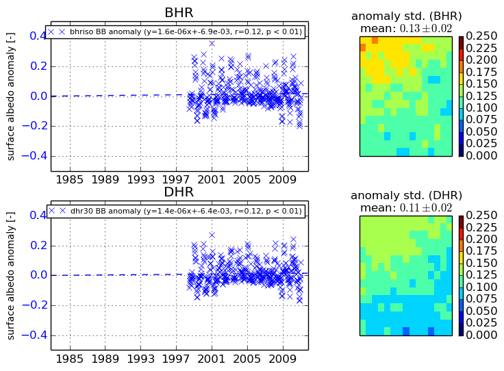
Temporal anomaly analyis

The variance of the temporal anomalies provides an additional measure about the stability of the signal AFTER removal of the mean seasonal cylce.

+000 deg


+057/+063 deg