JI_PARANA_SE


Location

lon / lat [deg]: -61.8515 / -10.9342

Source network: AERONET


Geostationary surface albedo (GSA) data


“+000”


“+057/+063”


Landcover information (based on ESA CCI landcover data)


Landcover fractions @ 2km distance


Landcover fractions @ 20 km distance


Legend


Distance to open water bodies [km]:

10.03

Distance to urban areas [km]:

5.46


Radius: 1 km

Number of landcover classes:

4

Dominant landcover type:

10: cropland, rainfed

Fraction of dominant landcover type [%]:

37.0


Radius: 2 km

Number of landcover classes:

5

Dominant landcover type:

11: cropland, rainfed, herbaceous cover

Fraction of dominant landcover type [%]:

35.0


Radius: 5 km

Number of landcover classes:

4

Dominant landcover type:

11: cropland, rainfed, herbaceous cover

Fraction of dominant landcover type [%]:

59.0


Radius: 10 km

Number of landcover classes:

5

Dominant landcover type:

11: cropland, rainfed, herbaceous cover

Fraction of dominant landcover type [%]:

47.0


Radius: 20 km

Number of landcover classes:

6

Dominant landcover type:

11: cropland, rainfed, herbaceous cover

Fraction of dominant landcover type [%]:

45.0


Disturbances


Heterogeneity analysis

The heterogeneity analysis provides information about the spatial and temporal heterogeneity of the site.

Topography


Roman et al. (2009) index


St

2.44261598943

Rcv

0.228154525657

Rse

0.0

Rst

-3.68942082972e-05

Rsv

-0.999999999902


Height range @ 1km [m]

9

Height range @ 2km [m]

17

Height range @ 5km [m]

29

Height range @ 10km [m]

-999

Height range @ 20km [m]

-999


Variance slope @ 1 km

3

Variance slope @ 2 km

6

Variance slope @ 5 km

16

Variance slope @ 10 km

-999

Variance slope @ 20 km

-999


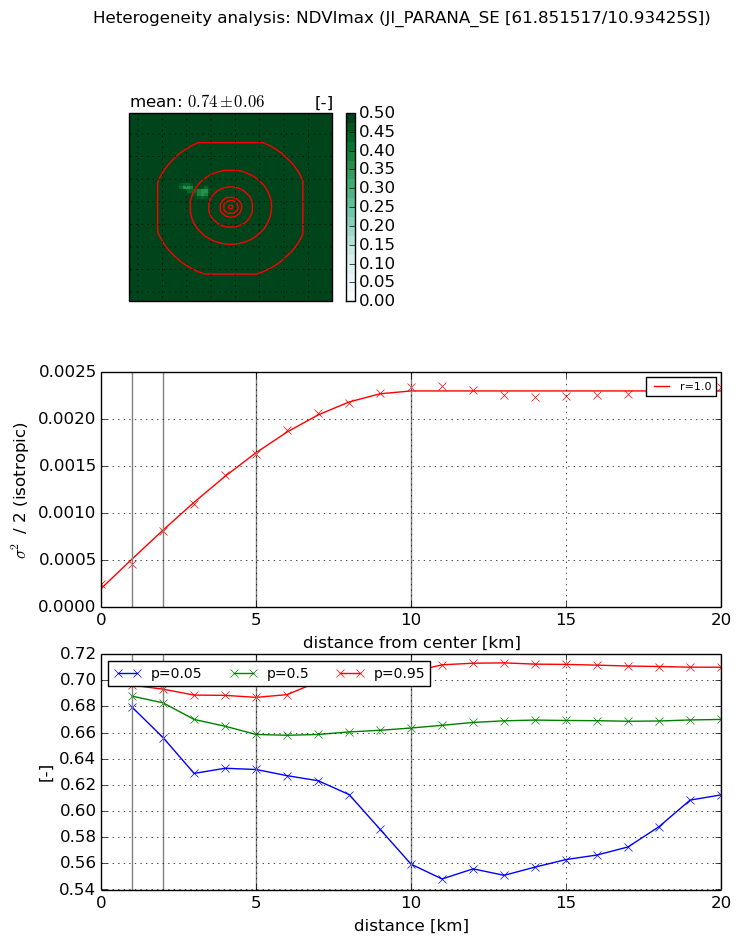
NDVI (max. NDVI composite)


Roman et al. (2009) index


St

29.6441924876

Rcv

-0.0546211335254

Rse

0.0

Rst

0.0307307951284

Rsv

-0.0158483317767


NDVI range @ 1km [-]

0.02

NDVI range @ 2km [-]

0.04

NDVI range @ 5km [-]

0.06

NDVI range @ 10km [-]

0.15

NDVI range @ 20km [-]

0.1


Variance slope @ 1 km

0.000213072493859

Variance slope @ 2 km

0.000283686069821

Variance slope @ 5 km

0.000285771994339

Variance slope @ 10 km

0.000219519130669

Variance slope @ 20 km

8.92987984659e-05


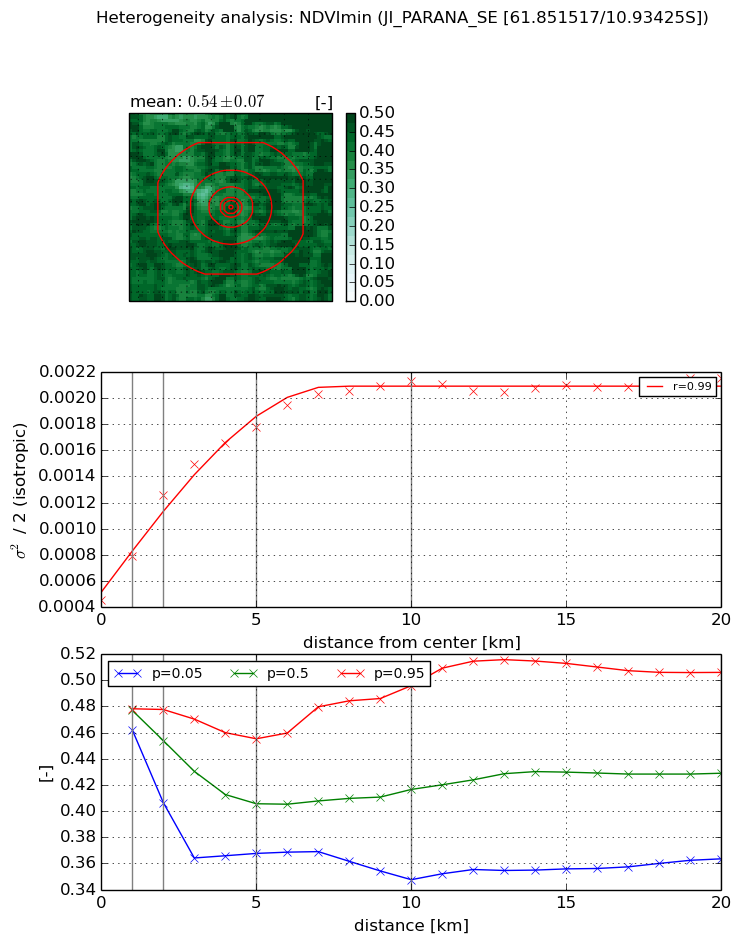
NDVI (min. NDVI composite)I


Roman et al. (2009) index


St

27.0938916171

Rcv

-0.06837668934

Rse

0.0

Rst

-0.0328490231054

Rsv

-0.00950035239589


NDVI range @ 1km [-]

0.02

NDVI range @ 2km [-]

0.07

NDVI range @ 5km [-]

0.09

NDVI range @ 10km [-]

0.15

NDVI range @ 20km [-]

0.14


NDVI slope @ 1 km

0.000338284619363

NDVI slope @ 2 km

0.000403622666404

NDVI slope @ 5 km

0.000270753312459

NDVI slope @ 10 km

0.000157682074439

NDVI slope @ 20 km

5.86430521869e-05


Temporal stability analysis

+000 deg (BHR)


BHR statistics

Temporal stability [1/decade]:


abs

rel


Weighted least square:

-99999.0


Ordinary least square:

-99999.0


Probabilities that GCOS criteria is met:

Weighted least square:

-99999.0 %

Ordinary least square:

-99999.0 %


DHR statistics

Temporal stability [1/decade]:


abs

rel


Weighted least square:

-99999.0


Ordinary least square:

-99999.0


Probabilities that GCOS criteria is met:

Weighted least square:

-99999.0 %

Ordinary least square:

-99999.0 %


+057/+063 deg (BHR)


BHR statistics

Temporal stability [1/decade]:


abs

rel


Weighted least square:

None


Ordinary least square:

None


Probabilities that GCOS criteria is met:

Weighted least square:

None %

Ordinary least square:

None %


DHR statistics

Temporal stability [1/decade]:


abs

rel


Weighted least square:

None


Ordinary least square:

None


Probabilities that GCOS criteria is met:

Weighted least square:

None %

Ordinary least square:

None %


Temporal anomaly analyis

The variance of the temporal anomalies provides an additional measure about the stability of the signal AFTER removal of the mean seasonal cylce.

+000 deg


+057/+063 deg