KAIPING


Location

lon / lat [deg]: 112.5386 / 22.3152

Source network: AERONET


Geostationary surface albedo (GSA) data


“+000”


“+057/+063”


Landcover information (based on ESA CCI landcover data)


Landcover fractions @ 2km distance


Landcover fractions @ 20 km distance


Legend


Distance to open water bodies [km]:

3.11

Distance to urban areas [km]:

2.21


Radius: 1 km

Number of landcover classes:

4

Dominant landcover type:

30: mosaic cropland (>50%), natural veg. (< 50%)

Fraction of dominant landcover type [%]:

37.0


Radius: 2 km

Number of landcover classes:

4

Dominant landcover type:

30: mosaic cropland (>50%), natural veg. (< 50%)

Fraction of dominant landcover type [%]:

42.0


Radius: 5 km

Number of landcover classes:

9

Dominant landcover type:

10: cropland, rainfed

Fraction of dominant landcover type [%]:

39.0


Radius: 10 km

Number of landcover classes:

9

Dominant landcover type:

10: cropland, rainfed

Fraction of dominant landcover type [%]:

33.0


Radius: 20 km

Number of landcover classes:

10

Dominant landcover type:

40: mosaic natural vegetation (tree, shrub, herbaceous cover) (>50%) / cropland (<50%)

Fraction of dominant landcover type [%]:

34.0


Disturbances


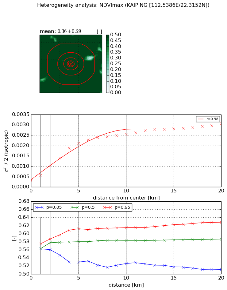
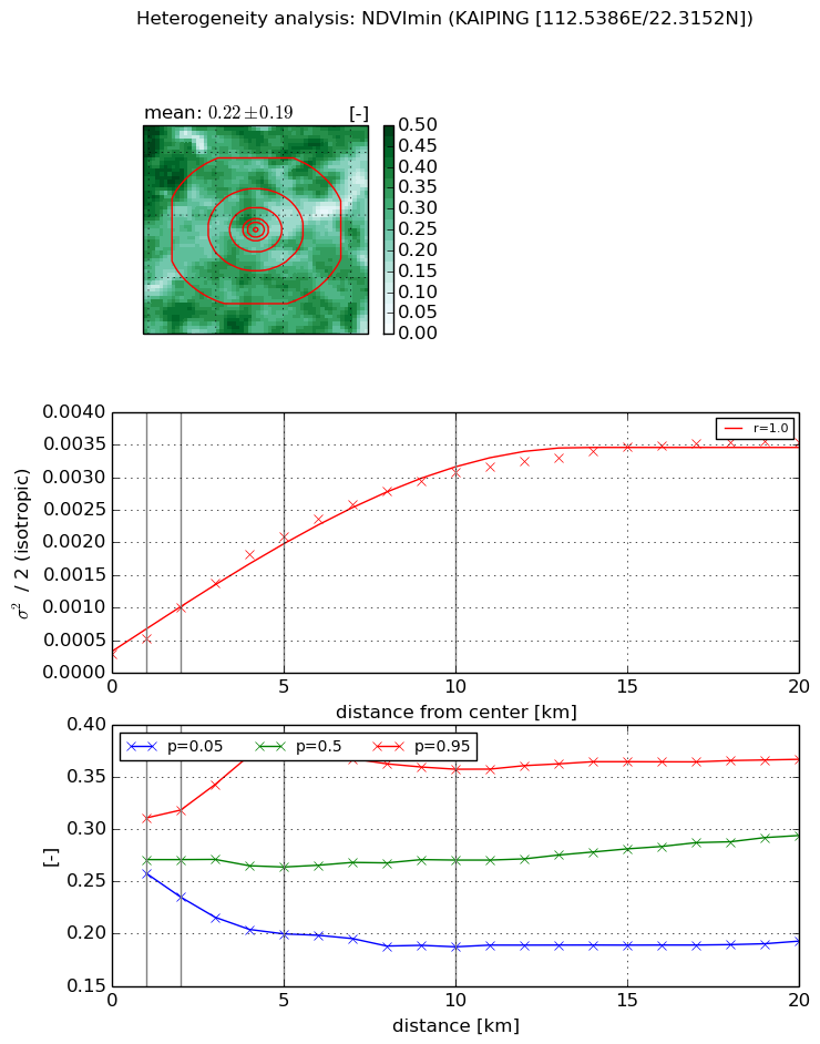
Heterogeneity analysis

The heterogeneity analysis provides information about the spatial and temporal heterogeneity of the site.

Topography


Roman et al. (2009) index


St

6.58832914988e-05

Rcv

1.11712302567

Rse

0.0

Rst

-0.156807060506

Rsv

45533.7916647


Height range @ 1km [m]

25

Height range @ 2km [m]

24

Height range @ 5km [m]

67

Height range @ 10km [m]

-999

Height range @ 20km [m]

-999


Variance slope @ 1 km

466

Variance slope @ 2 km

241

Variance slope @ 5 km

117

Variance slope @ 10 km

-999

Variance slope @ 20 km

-999


NDVI (max. NDVI composite)


Roman et al. (2009) index


St

7.76220954036e-08

Rcv

0.802880413363

Rse

0.0

Rst

2.1516530029

Rsv

38648786.2131


NDVI range @ 1km [-]

0.01

NDVI range @ 2km [-]

0.03

NDVI range @ 5km [-]

0.08

NDVI range @ 10km [-]

0.09

NDVI range @ 20km [-]

0.12


Variance slope @ 1 km

0.00026180832014

Variance slope @ 2 km

0.000361875211961

Variance slope @ 5 km

0.00038162183193

Variance slope @ 10 km

0.000231268297301

Variance slope @ 20 km

0.000114299635649


NDVI (min. NDVI composite)I


Roman et al. (2009) index


St

5.19679538316e-08

Rcv

0.26606253529

Rse

0.0

Rst

0.278597398733

Rsv

57727883.2531


NDVI range @ 1km [-]

0.05

NDVI range @ 2km [-]

0.08

NDVI range @ 5km [-]

0.19

NDVI range @ 10km [-]

0.17

NDVI range @ 20km [-]

0.17


NDVI slope @ 1 km

0.000250153576492

NDVI slope @ 2 km

0.000359024652061

NDVI slope @ 5 km

0.000380697538861

NDVI slope @ 10 km

0.000289915603803

NDVI slope @ 20 km

0.000155267838776


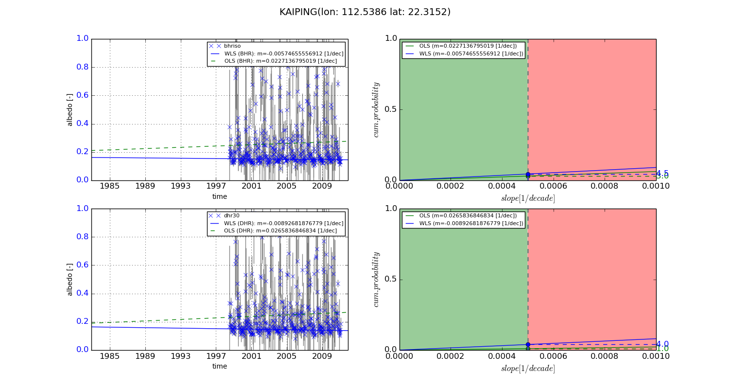
Temporal stability analysis

+000 deg (BHR)


BHR statistics

Temporal stability [1/decade]:


abs

rel


Weighted least square:

None


Ordinary least square:

None


Probabilities that GCOS criteria is met:

Weighted least square:

None %

Ordinary least square:

None %


DHR statistics

Temporal stability [1/decade]:


abs

rel


Weighted least square:

None


Ordinary least square:

None


Probabilities that GCOS criteria is met:

Weighted least square:

None %

Ordinary least square:

None %


+057/+063 deg (BHR)


BHR statistics

Temporal stability [1/decade]:


abs

rel


Weighted least square:

-0.00574655556912


Ordinary least square:

0.0227136795019


Probabilities that GCOS criteria is met:

Weighted least square:

4.5 %

Ordinary least square:

3.0 %


DHR statistics

Temporal stability [1/decade]:


abs

rel


Weighted least square:

-0.00892681876779


Ordinary least square:

0.0265836846834


Probabilities that GCOS criteria is met:

Weighted least square:

4.0 %

Ordinary least square:

1.0 %


Temporal anomaly analyis

The variance of the temporal anomalies provides an additional measure about the stability of the signal AFTER removal of the mean seasonal cylce.

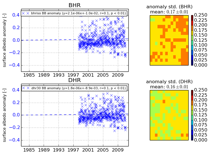
+000 deg


+057/+063 deg