LAMTO


Location

lon / lat [deg]: -5.03 / 6.21

Source network: AERONET


Geostationary surface albedo (GSA) data


“+000”


“+057/+063”


Landcover information (based on ESA CCI landcover data)


Landcover fractions @ 2km distance


Landcover fractions @ 20 km distance


Legend


Distance to open water bodies [km]:

5.04

Distance to urban areas [km]:

4.06


Radius: 1 km

Number of landcover classes:

3

Dominant landcover type:

10: cropland, rainfed

Fraction of dominant landcover type [%]:

48.0


Radius: 2 km

Number of landcover classes:

4

Dominant landcover type:

10: cropland, rainfed

Fraction of dominant landcover type [%]:

51.0


Radius: 5 km

Number of landcover classes:

7

Dominant landcover type:

10: cropland, rainfed

Fraction of dominant landcover type [%]:

56.0


Radius: 10 km

Number of landcover classes:

6

Dominant landcover type:

10: cropland, rainfed

Fraction of dominant landcover type [%]:

63.0


Radius: 20 km

Number of landcover classes:

6

Dominant landcover type:

10: cropland, rainfed

Fraction of dominant landcover type [%]:

77.0


Disturbances


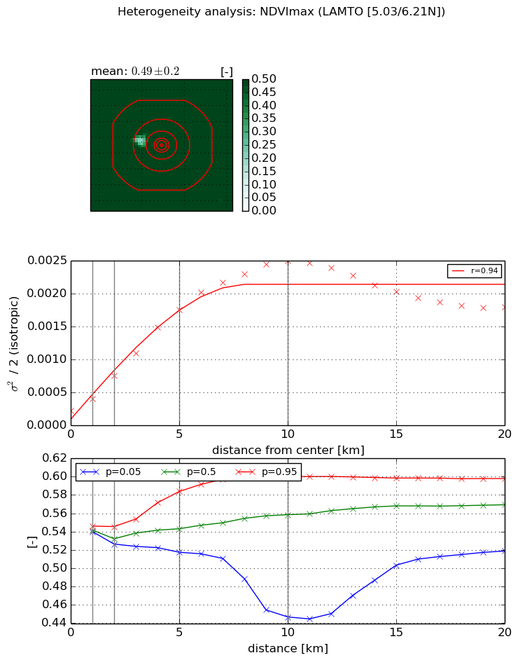
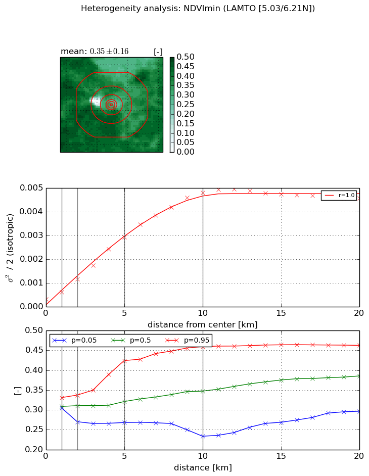
Heterogeneity analysis

The heterogeneity analysis provides information about the spatial and temporal heterogeneity of the site.

Topography


Roman et al. (2009) index


St

3.47930202799

Rcv

0.0520633750197

Rse

0.0

Rst

-0.0382151617815

Rsv

0.771963365703


Height range @ 1km [m]

22

Height range @ 2km [m]

33

Height range @ 5km [m]

52

Height range @ 10km [m]

-999

Height range @ 20km [m]

-999


Variance slope @ 1 km

94

Variance slope @ 2 km

100

Variance slope @ 5 km

78

Variance slope @ 10 km

-999

Variance slope @ 20 km

-999


NDVI (max. NDVI composite)


Roman et al. (2009) index


St

nan

Rcv

nan

Rse

nan

Rst

nan

Rsv

nan


NDVI range @ 1km [-]

0.01

NDVI range @ 2km [-]

0.02

NDVI range @ 5km [-]

0.07

NDVI range @ 10km [-]

0.15

NDVI range @ 20km [-]

0.08


Variance slope @ 1 km

0.000185358450419

Variance slope @ 2 km

0.000265475477018

Variance slope @ 5 km

0.000321440985704

Variance slope @ 10 km

0.000243785815767

Variance slope @ 20 km

6.10725446165e-05


NDVI (min. NDVI composite)I


Roman et al. (2009) index


St

1.6190228716e-07

Rcv

0.444962375814

Rse

0.0

Rst

0.265279945868

Rsv

18529694.2843


NDVI range @ 1km [-]

0.03

NDVI range @ 2km [-]

0.07

NDVI range @ 5km [-]

0.16

NDVI range @ 10km [-]

0.23

NDVI range @ 20km [-]

0.17


NDVI slope @ 1 km

0.000294975374826

NDVI slope @ 2 km

0.000424549850931

NDVI slope @ 5 km

0.000545745587172

NDVI slope @ 10 km

0.000477954775393

NDVI slope @ 20 km

0.000206579307287


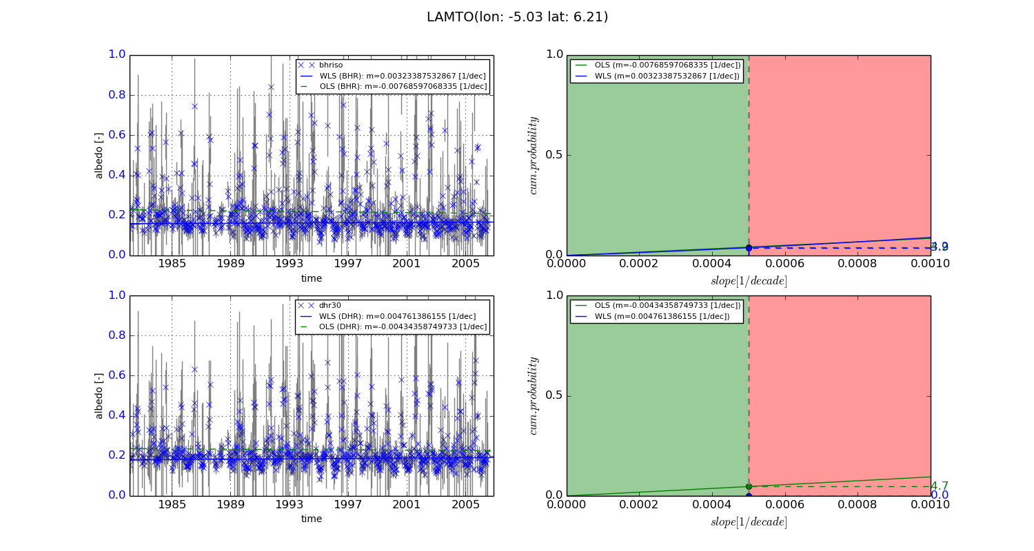
Temporal stability analysis

+000 deg (BHR)


BHR statistics

Temporal stability [1/decade]:


abs

rel


Weighted least square:

0.00323387532867


Ordinary least square:

-0.00768597068335


Probabilities that GCOS criteria is met:

Weighted least square:

3.9 %

Ordinary least square:

4.2 %


DHR statistics

Temporal stability [1/decade]:


abs

rel


Weighted least square:

0.004761386155


Ordinary least square:

-0.00434358749733


Probabilities that GCOS criteria is met:

Weighted least square:

0.0 %

Ordinary least square:

4.7 %


+057/+063 deg (BHR)


BHR statistics

Temporal stability [1/decade]:


abs

rel


Weighted least square:

-99999.0


Ordinary least square:

-99999.0


Probabilities that GCOS criteria is met:

Weighted least square:

-99999.0 %

Ordinary least square:

-99999.0 %


DHR statistics

Temporal stability [1/decade]:


abs

rel


Weighted least square:

-99999.0


Ordinary least square:

-99999.0


Probabilities that GCOS criteria is met:

Weighted least square:

-99999.0 %

Ordinary least square:

-99999.0 %


Temporal anomaly analyis

The variance of the temporal anomalies provides an additional measure about the stability of the signal AFTER removal of the mean seasonal cylce.
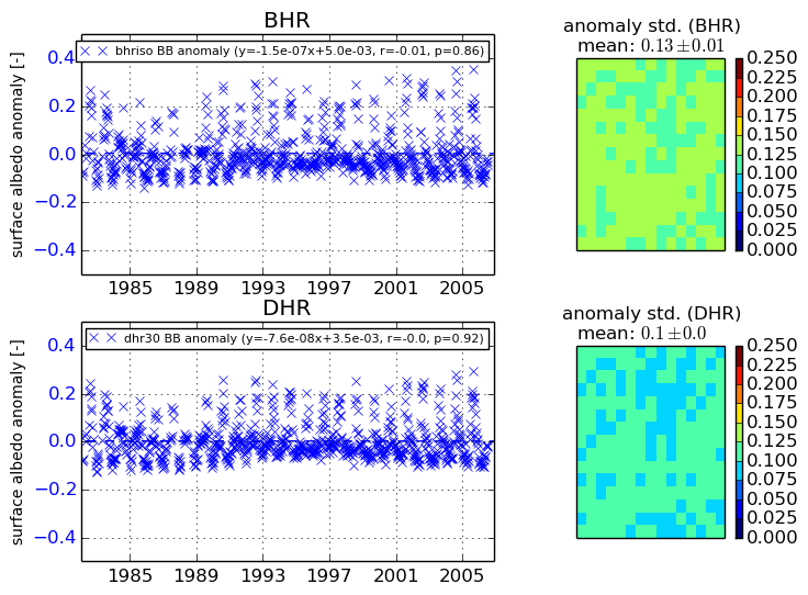
+000 deg


+057/+063 deg