NIWOT_RIDGE_LTER_NWT


Location

lon / lat [deg]: -105.38 / 39.99

Source network: LTER


Geostationary surface albedo (GSA) data


“+000”


“+057/+063”


Landcover information (based on ESA CCI landcover data)


Landcover fractions @ 2km distance


Landcover fractions @ 20 km distance


Legend


Distance to open water bodies [km]:

4.01

Distance to urban areas [km]:

1.38


Radius: 1 km

Number of landcover classes:

1

Dominant landcover type:

70: Tree cover, needleleaved, evergreen, closed to open (>15%)

Fraction of dominant landcover type [%]:

100.0


Radius: 2 km

Number of landcover classes:

3

Dominant landcover type:

70: Tree cover, needleleaved, evergreen, closed to open (>15%)

Fraction of dominant landcover type [%]:

94.0


Radius: 5 km

Number of landcover classes:

4

Dominant landcover type:

70: Tree cover, needleleaved, evergreen, closed to open (>15%)

Fraction of dominant landcover type [%]:

86.0


Radius: 10 km

Number of landcover classes:

3

Dominant landcover type:

70: Tree cover, needleleaved, evergreen, closed to open (>15%)

Fraction of dominant landcover type [%]:

86.0


Radius: 20 km

Number of landcover classes:

4

Dominant landcover type:

70: Tree cover, needleleaved, evergreen, closed to open (>15%)

Fraction of dominant landcover type [%]:

69.0


Disturbances


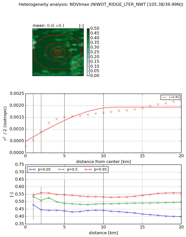
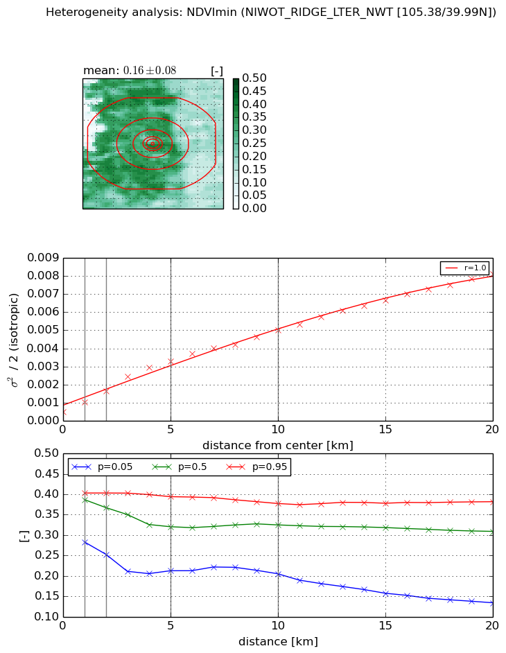
Heterogeneity analysis

The heterogeneity analysis provides information about the spatial and temporal heterogeneity of the site.

Topography


Roman et al. (2009) index


St

20.0895705803

Rcv

-0.0510413016605

Rse

0.0

Rst

-0.0917383899061

Rsv

-0.00655152425043


Height range @ 1km [m]

421

Height range @ 2km [m]

604

Height range @ 5km [m]

577

Height range @ 10km [m]

-999

Height range @ 20km [m]

-999


Variance slope @ 1 km

6253

Variance slope @ 2 km

6580

Variance slope @ 5 km

7107

Variance slope @ 10 km

-999

Variance slope @ 20 km

-999


NDVI (max. NDVI composite)


Roman et al. (2009) index


St

6.04516525787

Rcv

-0.120425237451

Rse

0.0

Rst

0.0487114902179

Rsv

-0.327127621117


NDVI range @ 1km [-]

0.07

NDVI range @ 2km [-]

0.11

NDVI range @ 5km [-]

0.11

NDVI range @ 10km [-]

0.09

NDVI range @ 20km [-]

0.16


Variance slope @ 1 km

0.000284676280416

Variance slope @ 2 km

0.00031347385351

Variance slope @ 5 km

0.000261889824665

Variance slope @ 10 km

0.00013064949075

Variance slope @ 20 km

7.28317507851e-05


NDVI (min. NDVI composite)I


Roman et al. (2009) index


St

7.91640584709

Rcv

-0.0479279826285

Rse

0.0

Rst

0.107603430292

Rsv

-0.223428440572


NDVI range @ 1km [-]

0.12

NDVI range @ 2km [-]

0.15

NDVI range @ 5km [-]

0.18

NDVI range @ 10km [-]

0.17

NDVI range @ 20km [-]

0.25


NDVI slope @ 1 km

0.000550774960019

NDVI slope @ 2 km

0.000575898086535

NDVI slope @ 5 km

0.000588364766982

NDVI slope @ 10 km

0.000440284635473

NDVI slope @ 20 km

0.00036333814332


Temporal stability analysis

+000 deg (BHR)


BHR statistics

Temporal stability [1/decade]:


abs

rel


Weighted least square:

None


Ordinary least square:

None


Probabilities that GCOS criteria is met:

Weighted least square:

None %

Ordinary least square:

None %


DHR statistics

Temporal stability [1/decade]:


abs

rel


Weighted least square:

None


Ordinary least square:

None


Probabilities that GCOS criteria is met:

Weighted least square:

None %

Ordinary least square:

None %


+057/+063 deg (BHR)


BHR statistics

Temporal stability [1/decade]:


abs

rel


Weighted least square:

None


Ordinary least square:

None


Probabilities that GCOS criteria is met:

Weighted least square:

None %

Ordinary least square:

None %


DHR statistics

Temporal stability [1/decade]:


abs

rel


Weighted least square:

None


Ordinary least square:

None


Probabilities that GCOS criteria is met:

Weighted least square:

None %

Ordinary least square:

None %


Temporal anomaly analyis

The variance of the temporal anomalies provides an additional measure about the stability of the signal AFTER removal of the mean seasonal cylce.

+000 deg


+057/+063 deg