US-ME1


Location

lon / lat [deg]: -121.5 / 44.5794

Source network: FLUXNET


Geostationary surface albedo (GSA) data


“+000”


“+057/+063”


Landcover information (based on ESA CCI landcover data)


Landcover fractions @ 2km distance


Landcover fractions @ 20 km distance


Legend


Distance to open water bodies [km]:

4.36

Distance to urban areas [km]:

10.26


Radius: 1 km

Number of landcover classes:

2

Dominant landcover type:

120: Shrubland

Fraction of dominant landcover type [%]:

59.0


Radius: 2 km

Number of landcover classes:

2

Dominant landcover type:

120: Shrubland

Fraction of dominant landcover type [%]:

51.0


Radius: 5 km

Number of landcover classes:

3

Dominant landcover type:

70: Tree cover, needleleaved, evergreen, closed to open (>15%)

Fraction of dominant landcover type [%]:

63.0


Radius: 10 km

Number of landcover classes:

3

Dominant landcover type:

70: Tree cover, needleleaved, evergreen, closed to open (>15%)

Fraction of dominant landcover type [%]:

70.0


Radius: 20 km

Number of landcover classes:

4

Dominant landcover type:

70: Tree cover, needleleaved, evergreen, closed to open (>15%)

Fraction of dominant landcover type [%]:

63.0


Disturbances


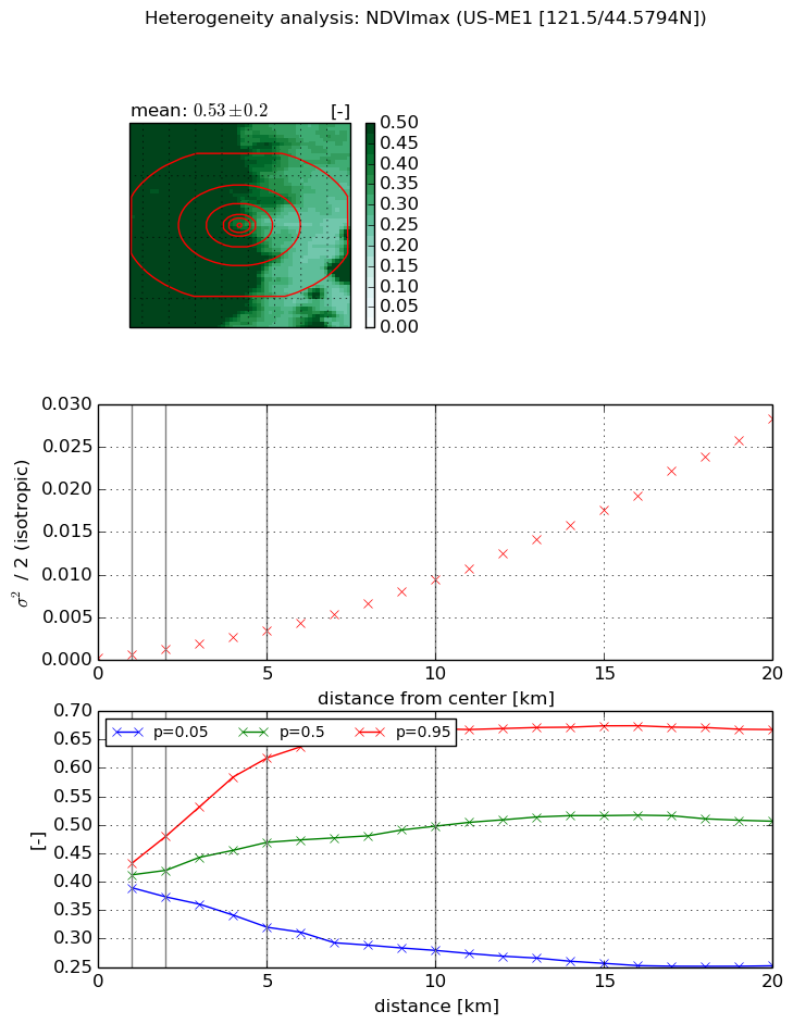
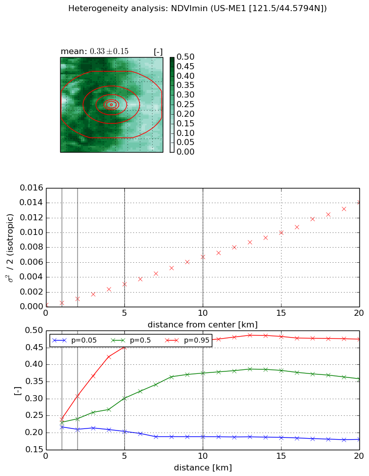
Heterogeneity analysis

The heterogeneity analysis provides information about the spatial and temporal heterogeneity of the site.

Topography


Roman et al. (2009) index


St

2.03089371192

Rcv

0.444282154462

Rse

0.0

Rst

-0.032900025184

Rsv

-1.0


Height range @ 1km [m]

145

Height range @ 2km [m]

288

Height range @ 5km [m]

521

Height range @ 10km [m]

-999

Height range @ 20km [m]

-999


Variance slope @ 1 km

3904

Variance slope @ 2 km

4206

Variance slope @ 5 km

5234

Variance slope @ 10 km

-999

Variance slope @ 20 km

-999


NDVI (max. NDVI composite)


Roman et al. (2009) index


St

1.79289215443

Rcv

0.692440977004

Rse

0.0

Rst

-3.72865788486e-07

Rsv

-0.980832746728


NDVI range @ 1km [-]

0.04

NDVI range @ 2km [-]

0.11

NDVI range @ 5km [-]

0.3

NDVI range @ 10km [-]

0.39

NDVI range @ 20km [-]

0.42


Variance slope @ 1 km

0.000376636405629

Variance slope @ 2 km

0.000490050556571

Variance slope @ 5 km

0.000657030684797

Variance slope @ 10 km

0.000910398463372

Variance slope @ 20 km

0.00141035363358


NDVI (min. NDVI composite)I


Roman et al. (2009) index


St

7.44564504841e-05

Rcv

0.379025268917

Rse

0.0

Rst

0.00867136997793

Rsv

40291.6216658


NDVI range @ 1km [-]

0.02

NDVI range @ 2km [-]

0.1

NDVI range @ 5km [-]

0.25

NDVI range @ 10km [-]

0.28

NDVI range @ 20km [-]

0.3


NDVI slope @ 1 km

0.000325534584664

NDVI slope @ 2 km

0.000431659626775

NDVI slope @ 5 km

0.000572702265871

NDVI slope @ 10 km

0.000666044338308

NDVI slope @ 20 km

0.000700200586338


Temporal stability analysis

+000 deg (BHR)


BHR statistics

Temporal stability [1/decade]:


abs

rel


Weighted least square:

None


Ordinary least square:

None


Probabilities that GCOS criteria is met:

Weighted least square:

None %

Ordinary least square:

None %


DHR statistics

Temporal stability [1/decade]:


abs

rel


Weighted least square:

None


Ordinary least square:

None


Probabilities that GCOS criteria is met:

Weighted least square:

None %

Ordinary least square:

None %


+057/+063 deg (BHR)


BHR statistics

Temporal stability [1/decade]:


abs

rel


Weighted least square:

None


Ordinary least square:

None


Probabilities that GCOS criteria is met:

Weighted least square:

None %

Ordinary least square:

None %


DHR statistics

Temporal stability [1/decade]:


abs

rel


Weighted least square:

None


Ordinary least square:

None


Probabilities that GCOS criteria is met:

Weighted least square:

None %

Ordinary least square:

None %


Temporal anomaly analyis

The variance of the temporal anomalies provides an additional measure about the stability of the signal AFTER removal of the mean seasonal cylce.

+000 deg


+057/+063 deg