ZA-KRU


Location

lon / lat [deg]: 31.4969 / -25.0197

Source network: FLUXNET


Geostationary surface albedo (GSA) data


“+000”


“+057/+063”


Landcover information (based on ESA CCI landcover data)


Landcover fractions @ 2km distance


Landcover fractions @ 20 km distance


Legend


Distance to open water bodies [km]:

4.98

Distance to urban areas [km]:

13.52


Radius: 1 km

Number of landcover classes:

2

Dominant landcover type:

62: Tree cover, broadleaved, decidous (open 15-40%)

Fraction of dominant landcover type [%]:

79.0


Radius: 2 km

Number of landcover classes:

4

Dominant landcover type:

120: Shrubland

Fraction of dominant landcover type [%]:

53.0


Radius: 5 km

Number of landcover classes:

4

Dominant landcover type:

120: Shrubland

Fraction of dominant landcover type [%]:

58.0


Radius: 10 km

Number of landcover classes:

5

Dominant landcover type:

120: Shrubland

Fraction of dominant landcover type [%]:

45.0


Radius: 20 km

Number of landcover classes:

6

Dominant landcover type:

62: Tree cover, broadleaved, decidous (open 15-40%)

Fraction of dominant landcover type [%]:

63.0


Disturbances


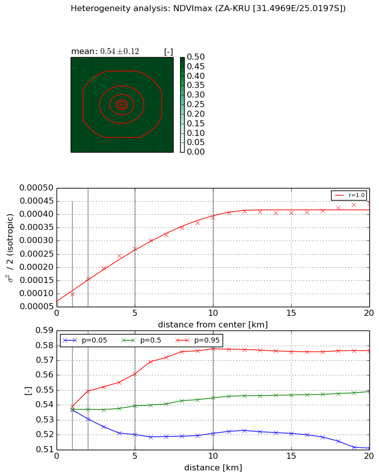
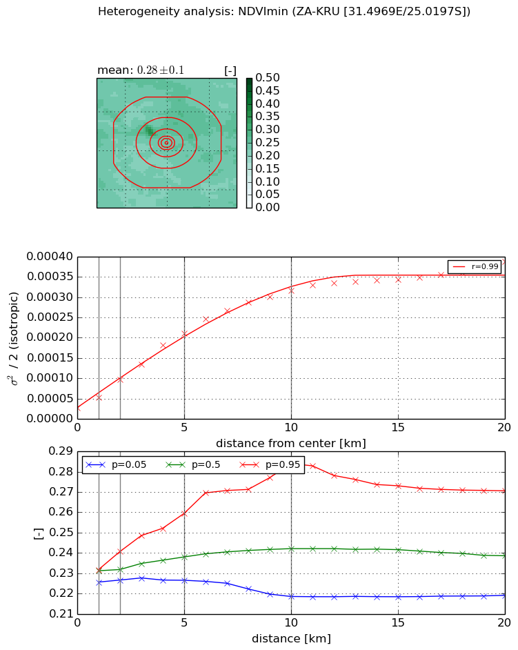
Heterogeneity analysis

The heterogeneity analysis provides information about the spatial and temporal heterogeneity of the site.

Topography


Roman et al. (2009) index


St

0.000559641058153

Rcv

0.556997491098

Rse

0.0

Rst

0.0362957338636

Rsv

5359.98552117


Height range @ 1km [m]

28

Height range @ 2km [m]

37

Height range @ 5km [m]

67

Height range @ 10km [m]

-999

Height range @ 20km [m]

-999


Variance slope @ 1 km

102

Variance slope @ 2 km

104

Variance slope @ 5 km

97

Variance slope @ 10 km

-999

Variance slope @ 20 km

-999


NDVI (max. NDVI composite)


Roman et al. (2009) index


St

9.46949948285e-08

Rcv

0.489642601879

Rse

0.0

Rst

0.170351707118

Rsv

31680660.0279


NDVI range @ 1km [-]

0.0

NDVI range @ 2km [-]

0.02

NDVI range @ 5km [-]

0.04

NDVI range @ 10km [-]

0.06

NDVI range @ 20km [-]

0.07


Variance slope @ 1 km

3.69640630334e-05

Variance slope @ 2 km

4.83077356636e-05

Variance slope @ 5 km

4.35305341818e-05

Variance slope @ 10 km

3.27119344856e-05

Variance slope @ 20 km

1.68933818375e-05


NDVI (min. NDVI composite)I


Roman et al. (2009) index


St

nan

Rcv

nan

Rse

nan

Rst

nan

Rsv

nan


NDVI range @ 1km [-]

0.01

NDVI range @ 2km [-]

0.01

NDVI range @ 5km [-]

0.03

NDVI range @ 10km [-]

0.07

NDVI range @ 20km [-]

0.05


NDVI slope @ 1 km

2.47714822667e-05

NDVI slope @ 2 km

3.5232838888e-05

NDVI slope @ 5 km

3.83195356478e-05

NDVI slope @ 10 km

3.03458391858e-05

NDVI slope @ 20 km

1.6304388612e-05


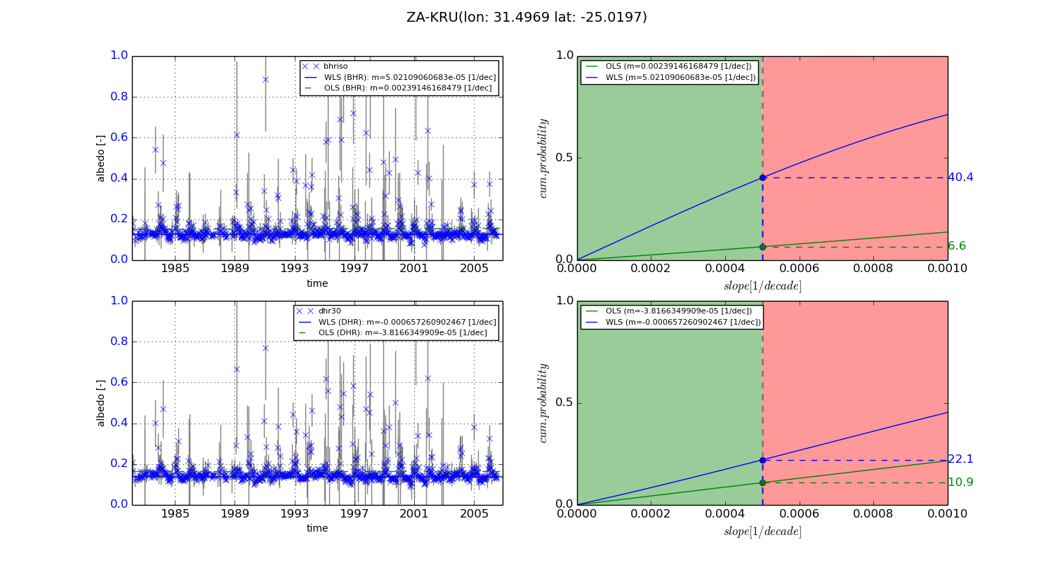
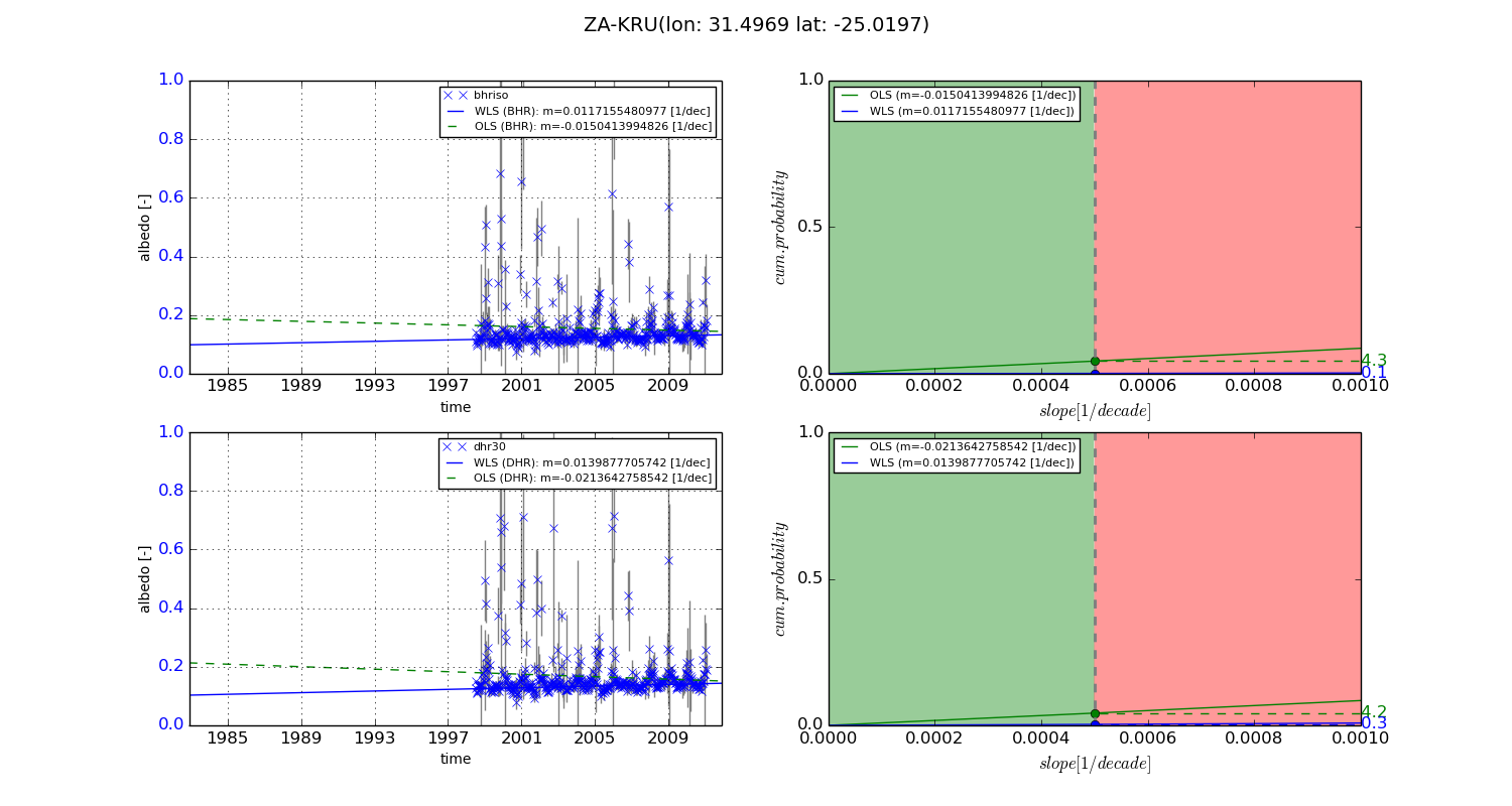
Temporal stability analysis

+000 deg (BHR)


BHR statistics

Temporal stability [1/decade]:


abs

rel


Weighted least square:

5.02109060683e-05


Ordinary least square:

0.00239146168479


Probabilities that GCOS criteria is met:

Weighted least square:

40.4 %

Ordinary least square:

6.6 %


DHR statistics

Temporal stability [1/decade]:


abs

rel


Weighted least square:

-0.000657260902467


Ordinary least square:

-3.8166349909e-05


Probabilities that GCOS criteria is met:

Weighted least square:

22.1 %

Ordinary least square:

10.9 %


+057/+063 deg (BHR)


BHR statistics

Temporal stability [1/decade]:


abs

rel


Weighted least square:

0.0117155480977


Ordinary least square:

-0.0150413994826


Probabilities that GCOS criteria is met:

Weighted least square:

0.1 %

Ordinary least square:

4.3 %


DHR statistics

Temporal stability [1/decade]:


abs

rel


Weighted least square:

0.0139877705742


Ordinary least square:

-0.0213642758542


Probabilities that GCOS criteria is met:

Weighted least square:

0.3 %

Ordinary least square:

4.2 %


Temporal anomaly analyis

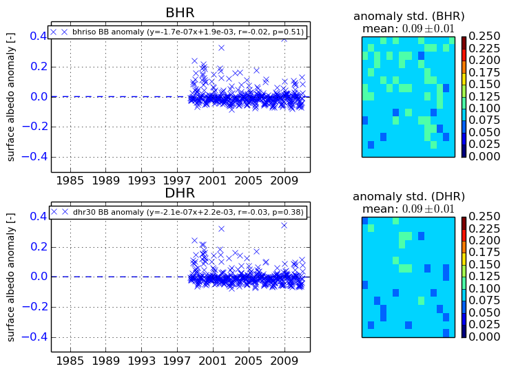
The variance of the temporal anomalies provides an additional measure about the stability of the signal AFTER removal of the mean seasonal cylce.
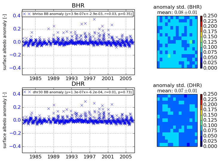
+000 deg


+057/+063 deg