AOE_BAOTOU


Location

lon / lat [deg]: 109.6288 / 40.8517

Source network: AERONET


Geostationary surface albedo (GSA) data


“+000”


“+057/+063”


Landcover information (based on ESA CCI landcover data)


Landcover fractions @ 2km distance


Landcover fractions @ 20 km distance


Legend


Distance to open water bodies [km]:

16.16

Distance to urban areas [km]:

5.18


Radius: 1 km

Number of landcover classes:

1

Dominant landcover type:

130: grassland

Fraction of dominant landcover type [%]:

100.0


Radius: 2 km

Number of landcover classes:

2

Dominant landcover type:

130: grassland

Fraction of dominant landcover type [%]:

93.0


Radius: 5 km

Number of landcover classes:

2

Dominant landcover type:

130: grassland

Fraction of dominant landcover type [%]:

90.0


Radius: 10 km

Number of landcover classes:

3

Dominant landcover type:

130: grassland

Fraction of dominant landcover type [%]:

84.0


Radius: 20 km

Number of landcover classes:

5

Dominant landcover type:

130: grassland

Fraction of dominant landcover type [%]:

68.0


Disturbances


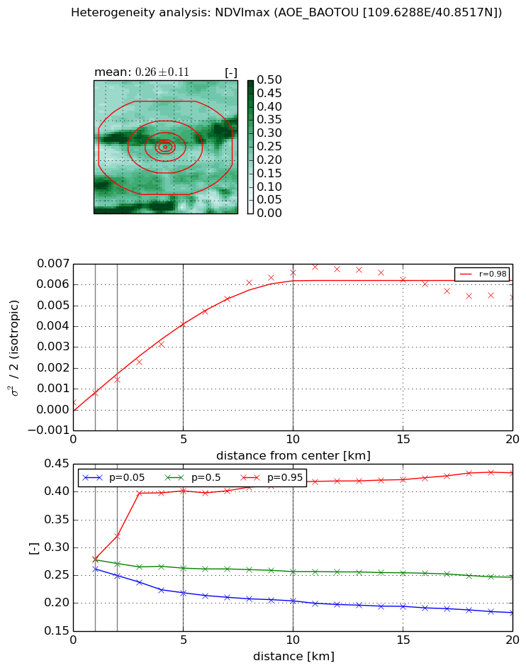
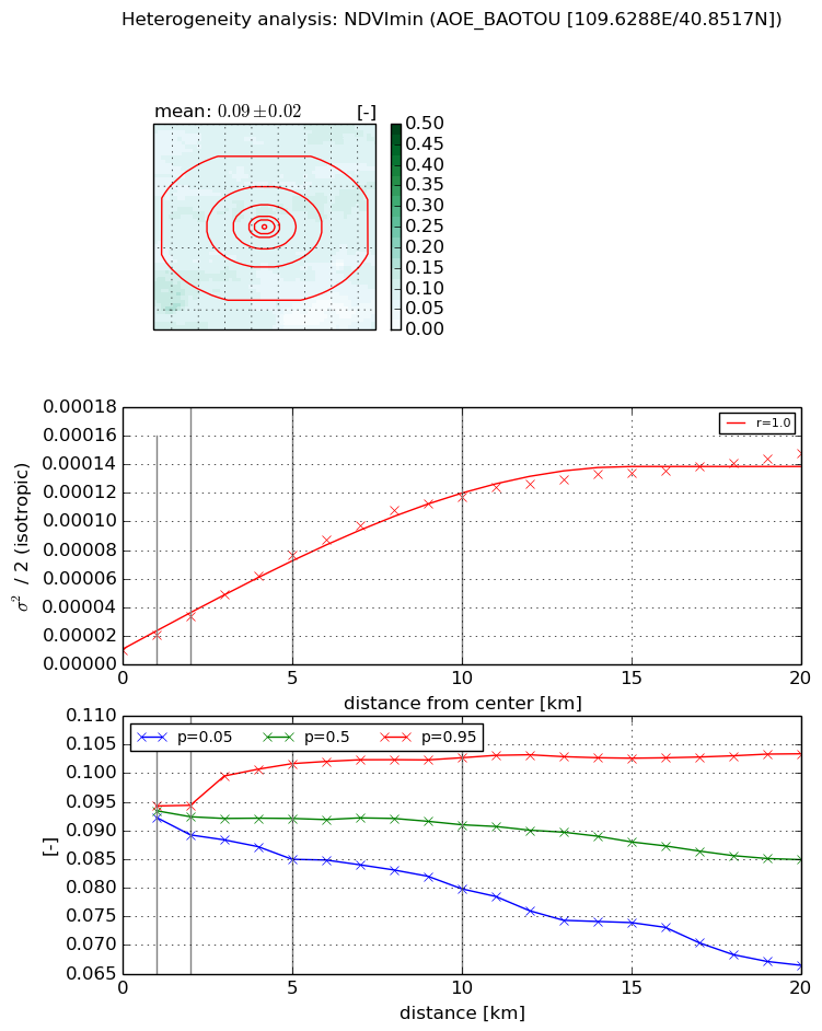
Heterogeneity analysis

The heterogeneity analysis provides information about the spatial and temporal heterogeneity of the site.

Topography


Roman et al. (2009) index


St

1.64397962771

Rcv

0.846411962936

Rse

0.0

Rst

0.0

Rsv

-0.978428168552


Height range @ 1km [m]

26

Height range @ 2km [m]

49

Height range @ 5km [m]

151

Height range @ 10km [m]

-999

Height range @ 20km [m]

-999


Variance slope @ 1 km

217

Variance slope @ 2 km

293

Variance slope @ 5 km

497

Variance slope @ 10 km

-999

Variance slope @ 20 km

-999


NDVI (max. NDVI composite)


Roman et al. (2009) index


St

2.14263257156

Rcv

0.197142309145

Rse

0.0

Rst

-0.203004852603

Rsv

-0.999999573544


NDVI range @ 1km [-]

0.02

NDVI range @ 2km [-]

0.07

NDVI range @ 5km [-]

0.18

NDVI range @ 10km [-]

0.21

NDVI range @ 20km [-]

0.25


Variance slope @ 1 km

0.000430098546671

Variance slope @ 2 km

0.000540315197583

Variance slope @ 5 km

0.000758631360872

Variance slope @ 10 km

0.000679315002271

Variance slope @ 20 km

0.00024656786588


NDVI (min. NDVI composite)I


Roman et al. (2009) index


St

3.35976405798

Rcv

0.584785203903

Rse

0.0

Rst

-1.81744330762e-08

Rsv

-0.30813462236


NDVI range @ 1km [-]

0.0

NDVI range @ 2km [-]

0.01

NDVI range @ 5km [-]

0.02

NDVI range @ 10km [-]

0.02

NDVI range @ 20km [-]

0.04


NDVI slope @ 1 km

1.05100424794e-05

NDVI slope @ 2 km

1.18280085349e-05

NDVI slope @ 5 km

1.34812665191e-05

NDVI slope @ 10 km

1.13485084635e-05

NDVI slope @ 20 km

6.54396813226e-06


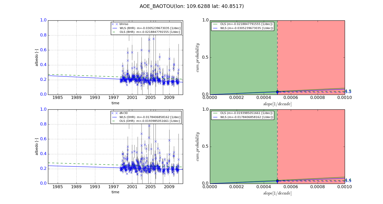
Temporal stability analysis

+000 deg (BHR)


BHR statistics

Temporal stability [1/decade]:


abs

rel


Weighted least square:

None


Ordinary least square:

None


Probabilities that GCOS criteria is met:

Weighted least square:

None %

Ordinary least square:

None %


DHR statistics

Temporal stability [1/decade]:


abs

rel


Weighted least square:

None


Ordinary least square:

None


Probabilities that GCOS criteria is met:

Weighted least square:

None %

Ordinary least square:

None %


+057/+063 deg (BHR)


BHR statistics

Temporal stability [1/decade]:


abs

rel


Weighted least square:

-0.0305239673035


Ordinary least square:

-0.0218847791555


Probabilities that GCOS criteria is met:

Weighted least square:

3.5 %

Ordinary least square:

4.3 %


DHR statistics

Temporal stability [1/decade]:


abs

rel


Weighted least square:

-0.0178406858162


Ordinary least square:

-0.0193985051661


Probabilities that GCOS criteria is met:

Weighted least square:

3.5 %

Ordinary least square:

4.4 %


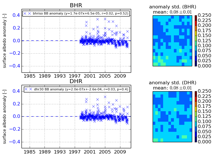
Temporal anomaly analyis

The variance of the temporal anomalies provides an additional measure about the stability of the signal AFTER removal of the mean seasonal cylce.

+000 deg


+057/+063 deg