AUTILLA


Location

lon / lat [deg]: -4.6031 / 41.9972

Source network: AERONET


Geostationary surface albedo (GSA) data


“+000”


“+057/+063”


Landcover information (based on ESA CCI landcover data)


Landcover fractions @ 2km distance


Landcover fractions @ 20 km distance


Legend


Distance to open water bodies [km]:

14.03

Distance to urban areas [km]:

5.16


Radius: 1 km

Number of landcover classes:

1

Dominant landcover type:

10: cropland, rainfed

Fraction of dominant landcover type [%]:

100.0


Radius: 2 km

Number of landcover classes:

1

Dominant landcover type:

10: cropland, rainfed

Fraction of dominant landcover type [%]:

100.0


Radius: 5 km

Number of landcover classes:

4

Dominant landcover type:

10: cropland, rainfed

Fraction of dominant landcover type [%]:

77.0


Radius: 10 km

Number of landcover classes:

5

Dominant landcover type:

10: cropland, rainfed

Fraction of dominant landcover type [%]:

59.0


Radius: 20 km

Number of landcover classes:

4

Dominant landcover type:

10: cropland, rainfed

Fraction of dominant landcover type [%]:

68.0


Disturbances


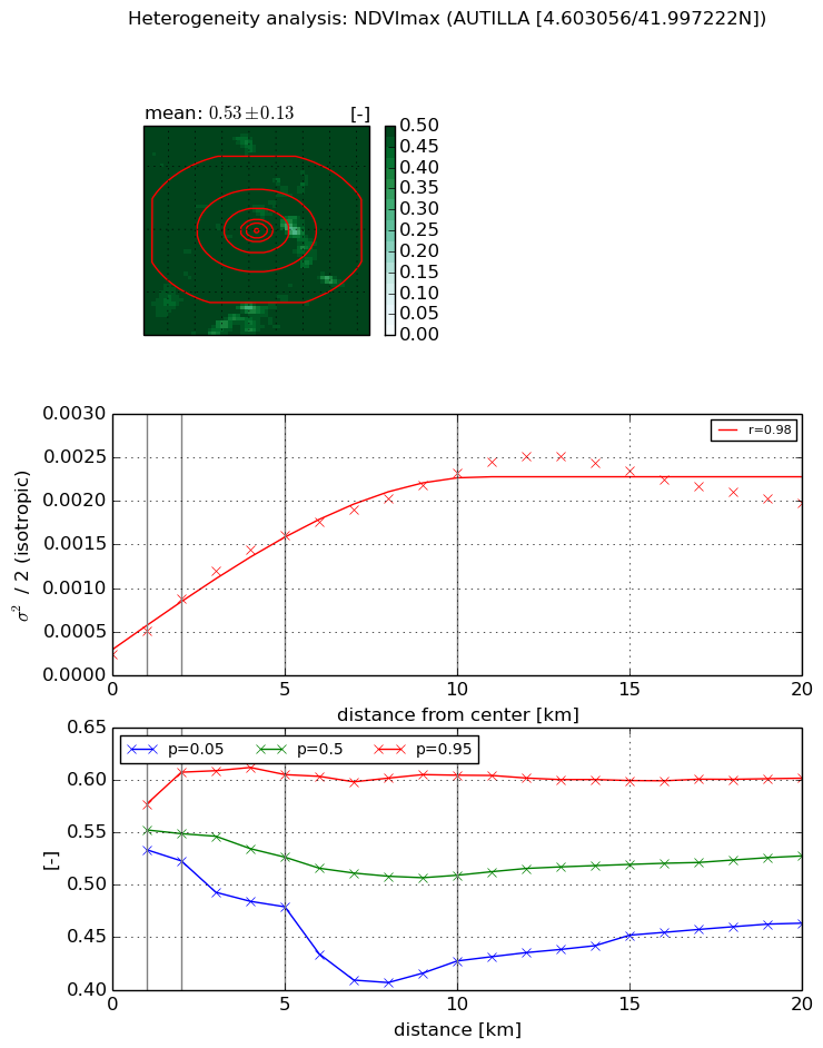
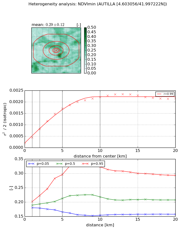
Heterogeneity analysis

The heterogeneity analysis provides information about the spatial and temporal heterogeneity of the site.

Topography


Roman et al. (2009) index


St

0.000104728476082

Rcv

0.653519404197

Rse

0.0

Rst

0.0945033024934

Rsv

28644.7561632


Height range @ 1km [m]

6

Height range @ 2km [m]

32

Height range @ 5km [m]

137

Height range @ 10km [m]

-999

Height range @ 20km [m]

-999


Variance slope @ 1 km

430

Variance slope @ 2 km

578

Variance slope @ 5 km

766

Variance slope @ 10 km

-999

Variance slope @ 20 km

-999


NDVI (max. NDVI composite)


Roman et al. (2009) index


St

2.85733972568

Rcv

0.24816385932

Rse

0.0

Rst

-0.103271137407

Rsv

0.698492659071


NDVI range @ 1km [-]

0.04

NDVI range @ 2km [-]

0.08

NDVI range @ 5km [-]

0.13

NDVI range @ 10km [-]

0.18

NDVI range @ 20km [-]

0.14


Variance slope @ 1 km

0.000269887022261

Variance slope @ 2 km

0.000318137326059

Variance slope @ 5 km

0.000282974580103

Variance slope @ 10 km

0.000201667609336

Variance slope @ 20 km

8.03040659788e-05


NDVI (min. NDVI composite)I


Roman et al. (2009) index


St

1.20480238653e-06

Rcv

0.732190042771

Rse

0.0

Rst

0.127001034974

Rsv

2490034.04907


NDVI range @ 1km [-]

0.02

NDVI range @ 2km [-]

0.04

NDVI range @ 5km [-]

0.13

NDVI range @ 10km [-]

0.17

NDVI range @ 20km [-]

0.14


NDVI slope @ 1 km

0.000245373544585

NDVI slope @ 2 km

0.000305315428953

NDVI slope @ 5 km

0.000313096571494

NDVI slope @ 10 km

0.000205806586744

NDVI slope @ 20 km

8.2074737869e-05


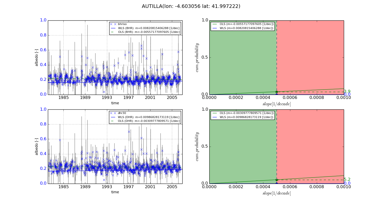
Temporal stability analysis

+000 deg (BHR)


BHR statistics

Temporal stability [1/decade]:


abs

rel


Weighted least square:

0.00820815406288


Ordinary least square:

-0.00557177097605


Probabilities that GCOS criteria is met:

Weighted least square:

0.0 %

Ordinary least square:

3.9 %


DHR statistics

Temporal stability [1/decade]:


abs

rel


Weighted least square:

0.00986828173119


Ordinary least square:

-0.00309777809571


Probabilities that GCOS criteria is met:

Weighted least square:

0.0 %

Ordinary least square:

5.2 %


+057/+063 deg (BHR)


BHR statistics

Temporal stability [1/decade]:


abs

rel


Weighted least square:

-99999.0


Ordinary least square:

-99999.0


Probabilities that GCOS criteria is met:

Weighted least square:

-99999.0 %

Ordinary least square:

-99999.0 %


DHR statistics

Temporal stability [1/decade]:


abs

rel


Weighted least square:

-99999.0


Ordinary least square:

-99999.0


Probabilities that GCOS criteria is met:

Weighted least square:

-99999.0 %

Ordinary least square:

-99999.0 %


Temporal anomaly analyis

The variance of the temporal anomalies provides an additional measure about the stability of the signal AFTER removal of the mean seasonal cylce.
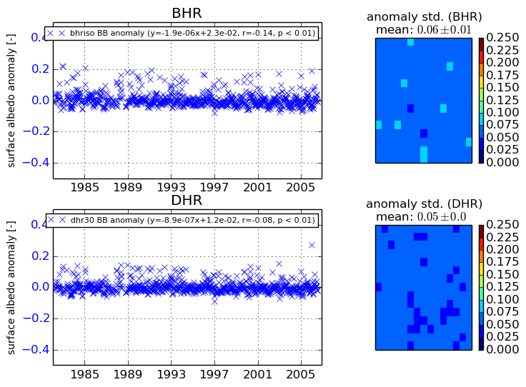
+000 deg


+057/+063 deg