BARRANCO


Location

lon / lat [deg]: 37.3278 / -3.0957

Source network: AERONET


Geostationary surface albedo (GSA) data


“+000”


“+057/+063”


Landcover information (based on ESA CCI landcover data)


Landcover fractions @ 2km distance


Landcover fractions @ 20 km distance


Legend


Distance to open water bodies [km]:

1.03

Distance to urban areas [km]:

25.42


Radius: 1 km

Number of landcover classes:

2

Dominant landcover type:

120: Shrubland

Fraction of dominant landcover type [%]:

94.0


Radius: 2 km

Number of landcover classes:

5

Dominant landcover type:

120: Shrubland

Fraction of dominant landcover type [%]:

68.0


Radius: 5 km

Number of landcover classes:

6

Dominant landcover type:

120: Shrubland

Fraction of dominant landcover type [%]:

47.0


Radius: 10 km

Number of landcover classes:

8

Dominant landcover type:

120: Shrubland

Fraction of dominant landcover type [%]:

33.0


Radius: 20 km

Number of landcover classes:

9

Dominant landcover type:

120: Shrubland

Fraction of dominant landcover type [%]:

38.0


Disturbances


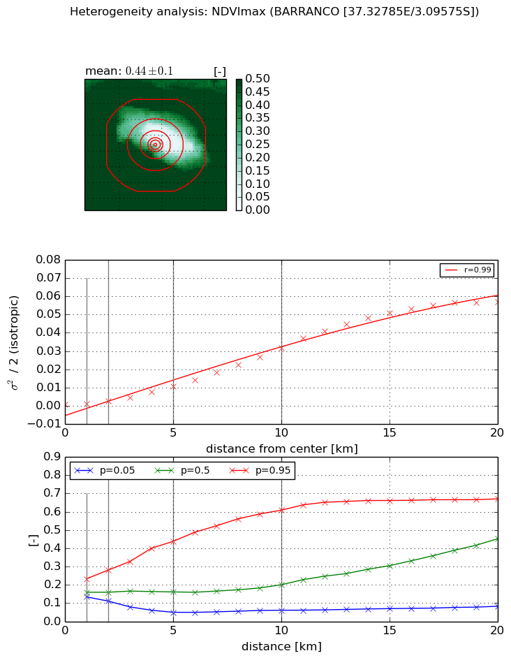
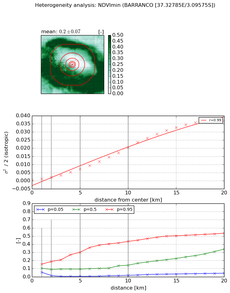
Heterogeneity analysis

The heterogeneity analysis provides information about the spatial and temporal heterogeneity of the site.

Topography


Roman et al. (2009) index


St

1.70722952502e-07

Rcv

0.593387105042

Rse

0.0

Rst

7.79046605004e-10

Rsv

17572329.0555


Height range @ 1km [m]

480

Height range @ 2km [m]

945

Height range @ 5km [m]

2788

Height range @ 10km [m]

-999

Height range @ 20km [m]

-999


Variance slope @ 1 km

29738

Variance slope @ 2 km

52321

Variance slope @ 5 km

113070

Variance slope @ 10 km

-999

Variance slope @ 20 km

-999


NDVI (max. NDVI composite)


Roman et al. (2009) index


St

0.00279937667312

Rcv

0.425711963776

Rse

0.0

Rst

1.09712564343e-07

Rsv

1071.2414304


NDVI range @ 1km [-]

0.1

NDVI range @ 2km [-]

0.17

NDVI range @ 5km [-]

0.39

NDVI range @ 10km [-]

0.55

NDVI range @ 20km [-]

0.59


Variance slope @ 1 km

0.000692282833018

Variance slope @ 2 km

0.00110910653164

Variance slope @ 5 km

0.00205568556438

Variance slope @ 10 km

0.00319017604086

Variance slope @ 20 km

0.00334893887452


NDVI (min. NDVI composite)I


Roman et al. (2009) index


St

0.0879950906139

Rcv

0.15379201336

Rse

0.0

Rst

2.59471800616e-07

Rsv

33.9390188041


NDVI range @ 1km [-]

0.1

NDVI range @ 2km [-]

0.17

NDVI range @ 5km [-]

0.3

NDVI range @ 10km [-]

0.42

NDVI range @ 20km [-]

0.49


NDVI slope @ 1 km

0.00050261156385

NDVI slope @ 2 km

0.000781466722106

NDVI slope @ 5 km

0.00135160175672

NDVI slope @ 10 km

0.00200899267577

NDVI slope @ 20 km

0.00214679184117


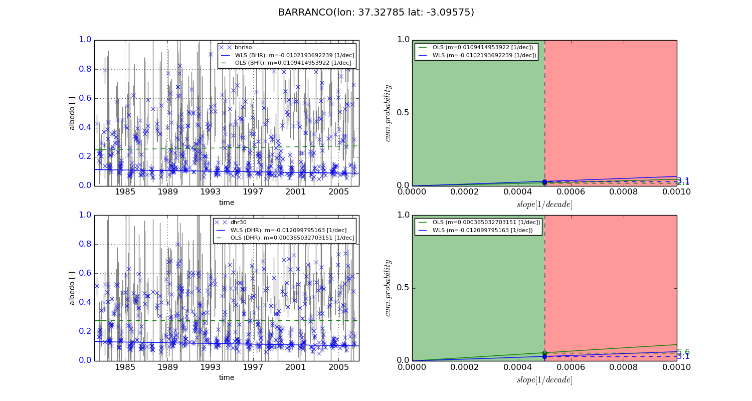
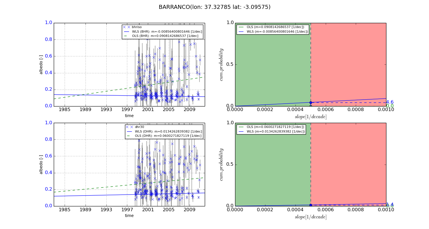
Temporal stability analysis

+000 deg (BHR)


BHR statistics

Temporal stability [1/decade]:


abs

rel


Weighted least square:

-0.0102193692239


Ordinary least square:

0.0109414953922


Probabilities that GCOS criteria is met:

Weighted least square:

3.1 %

Ordinary least square:

2.1 %


DHR statistics

Temporal stability [1/decade]:


abs

rel


Weighted least square:

-0.012099795163


Ordinary least square:

0.000365032703151


Probabilities that GCOS criteria is met:

Weighted least square:

3.1 %

Ordinary least square:

5.6 %


+057/+063 deg (BHR)


BHR statistics

Temporal stability [1/decade]:


abs

rel


Weighted least square:

-0.00856400801646


Ordinary least square:

0.0908142686537


Probabilities that GCOS criteria is met:

Weighted least square:

4.6 %

Ordinary least square:

0.0 %


DHR statistics

Temporal stability [1/decade]:


abs

rel


Weighted least square:

0.0134262839382


Ordinary least square:

0.0600271827119


Probabilities that GCOS criteria is met:

Weighted least square:

1.4 %

Ordinary least square:

0.0 %


Temporal anomaly analyis

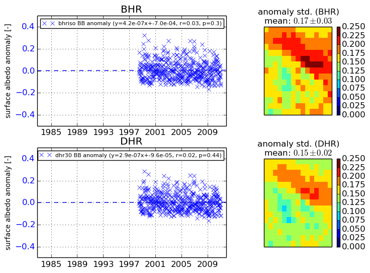
The variance of the temporal anomalies provides an additional measure about the stability of the signal AFTER removal of the mean seasonal cylce.
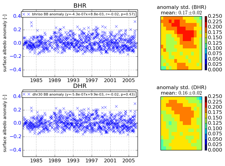
+000 deg


+057/+063 deg