BELMANIP_00026


Location

lon / lat [deg]: -50.0985 / -16.8169

Source network: BELMANIP


Geostationary surface albedo (GSA) data


“+000”


“+057/+063”


Landcover information (based on ESA CCI landcover data)


Landcover fractions @ 2km distance


Landcover fractions @ 20 km distance


Legend


Distance to open water bodies [km]:

6.85

Distance to urban areas [km]:

5.9


Radius: 1 km

Number of landcover classes:

1

Dominant landcover type:

10: cropland, rainfed

Fraction of dominant landcover type [%]:

100.0


Radius: 2 km

Number of landcover classes:

1

Dominant landcover type:

10: cropland, rainfed

Fraction of dominant landcover type [%]:

100.0


Radius: 5 km

Number of landcover classes:

1

Dominant landcover type:

10: cropland, rainfed

Fraction of dominant landcover type [%]:

100.0


Radius: 10 km

Number of landcover classes:

1

Dominant landcover type:

10: cropland, rainfed

Fraction of dominant landcover type [%]:

99.0


Radius: 20 km

Number of landcover classes:

1

Dominant landcover type:

10: cropland, rainfed

Fraction of dominant landcover type [%]:

98.0


Disturbances


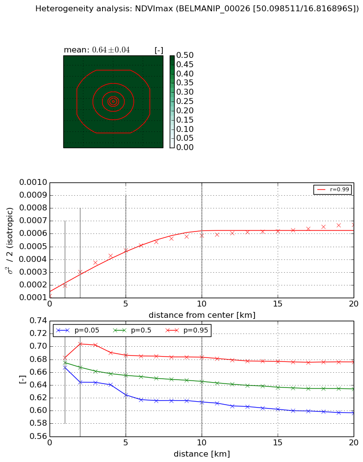
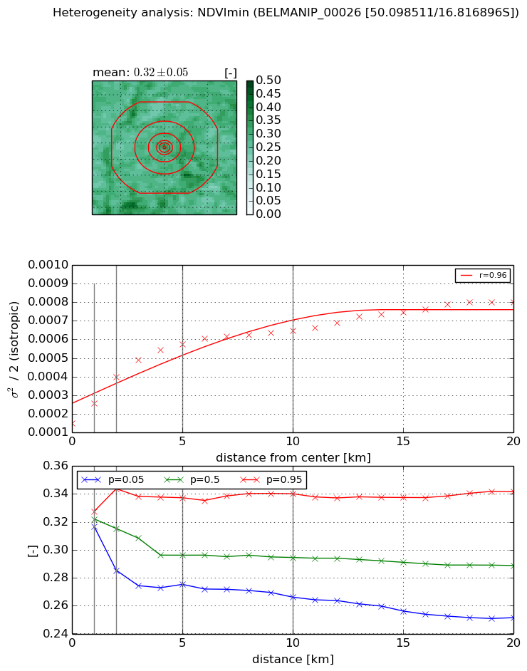
Heterogeneity analysis

The heterogeneity analysis provides information about the spatial and temporal heterogeneity of the site.

Topography


Roman et al. (2009) index


St

3.41899790908

Rcv

0.123916461182

Rse

0.0

Rst

-0.111435170273

Rsv

0.64209845181


Height range @ 1km [m]

39

Height range @ 2km [m]

124

Height range @ 5km [m]

136

Height range @ 10km [m]

-999

Height range @ 20km [m]

-999


Variance slope @ 1 km

515

Variance slope @ 2 km

477

Variance slope @ 5 km

279

Variance slope @ 10 km

-999

Variance slope @ 20 km

-999


NDVI (max. NDVI composite)


Roman et al. (2009) index


St

1.2705594295

Rcv

0.116720841322

Rse

0.0

Rst

-0.749833583422

Rsv

1.49461021686


NDVI range @ 1km [-]

0.02

NDVI range @ 2km [-]

0.06

NDVI range @ 5km [-]

0.06

NDVI range @ 10km [-]

0.07

NDVI range @ 20km [-]

0.08


Variance slope @ 1 km

7.97539082774e-05

Variance slope @ 2 km

9.38820832411e-05

Variance slope @ 5 km

7.27415729985e-05

Variance slope @ 10 km

4.5785252328e-05

Variance slope @ 20 km

2.22491757831e-05


NDVI (min. NDVI composite)I


Roman et al. (2009) index


St

11.7511300573

Rcv

-0.113974671023

Rse

0.0

Rst

-0.0213314568222

Rsv

0.11998846811


NDVI range @ 1km [-]

0.01

NDVI range @ 2km [-]

0.06

NDVI range @ 5km [-]

0.06

NDVI range @ 10km [-]

0.07

NDVI range @ 20km [-]

0.09


NDVI slope @ 1 km

0.000107807049618

NDVI slope @ 2 km

0.00012411111365

NDVI slope @ 5 km

8.78052363805e-05

NDVI slope @ 10 km

4.53547138085e-05

NDVI slope @ 20 km

2.57354364145e-05


Temporal stability analysis

+000 deg (BHR)


BHR statistics

Temporal stability [1/decade]:


abs

rel


Weighted least square:

-99999.0


Ordinary least square:

-99999.0


Probabilities that GCOS criteria is met:

Weighted least square:

-99999.0 %

Ordinary least square:

-99999.0 %


DHR statistics

Temporal stability [1/decade]:


abs

rel


Weighted least square:

-99999.0


Ordinary least square:

-99999.0


Probabilities that GCOS criteria is met:

Weighted least square:

-99999.0 %

Ordinary least square:

-99999.0 %


+057/+063 deg (BHR)


BHR statistics

Temporal stability [1/decade]:


abs

rel


Weighted least square:

None


Ordinary least square:

None


Probabilities that GCOS criteria is met:

Weighted least square:

None %

Ordinary least square:

None %


DHR statistics

Temporal stability [1/decade]:


abs

rel


Weighted least square:

None


Ordinary least square:

None


Probabilities that GCOS criteria is met:

Weighted least square:

None %

Ordinary least square:

None %


Temporal anomaly analyis

The variance of the temporal anomalies provides an additional measure about the stability of the signal AFTER removal of the mean seasonal cylce.

+000 deg


+057/+063 deg