BELMANIP_00066


Location

lon / lat [deg]: -109.5711 / 38.2555

Source network: BELMANIP


Geostationary surface albedo (GSA) data


“+000”


“+057/+063”


Landcover information (based on ESA CCI landcover data)


Landcover fractions @ 2km distance


Landcover fractions @ 20 km distance


Legend


Distance to open water bodies [km]:

17.61

Distance to urban areas [km]:

15.82


Radius: 1 km

Number of landcover classes:

1

Dominant landcover type:

120: Shrubland

Fraction of dominant landcover type [%]:

100.0


Radius: 2 km

Number of landcover classes:

1

Dominant landcover type:

120: Shrubland

Fraction of dominant landcover type [%]:

100.0


Radius: 5 km

Number of landcover classes:

1

Dominant landcover type:

120: Shrubland

Fraction of dominant landcover type [%]:

100.0


Radius: 10 km

Number of landcover classes:

2

Dominant landcover type:

120: Shrubland

Fraction of dominant landcover type [%]:

98.0


Radius: 20 km

Number of landcover classes:

2

Dominant landcover type:

120: Shrubland

Fraction of dominant landcover type [%]:

96.0


Disturbances


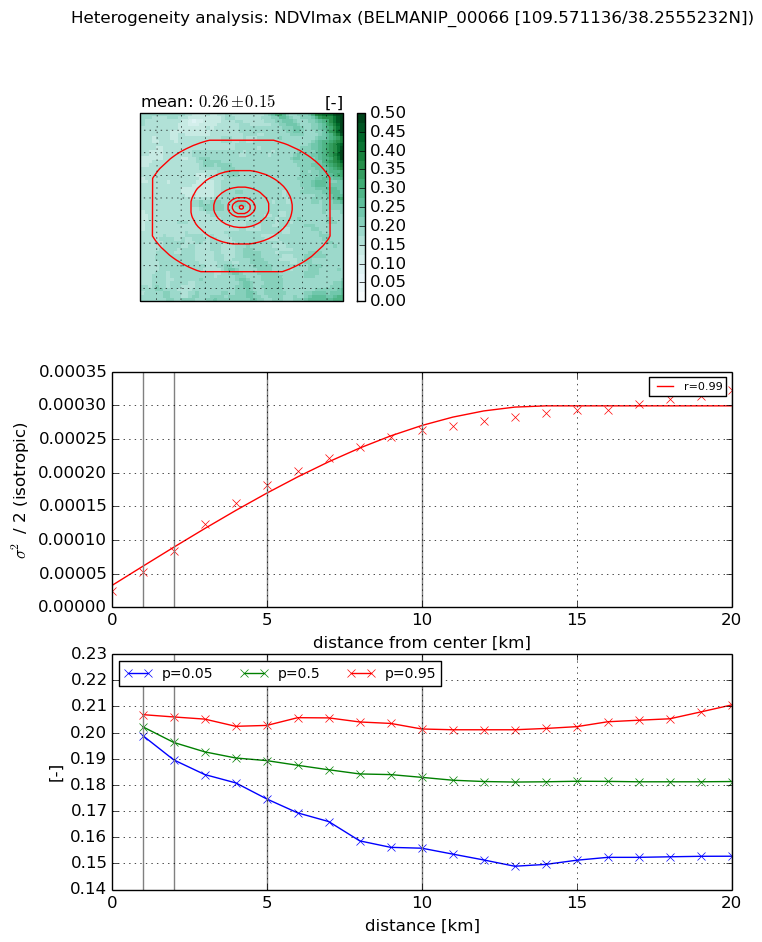
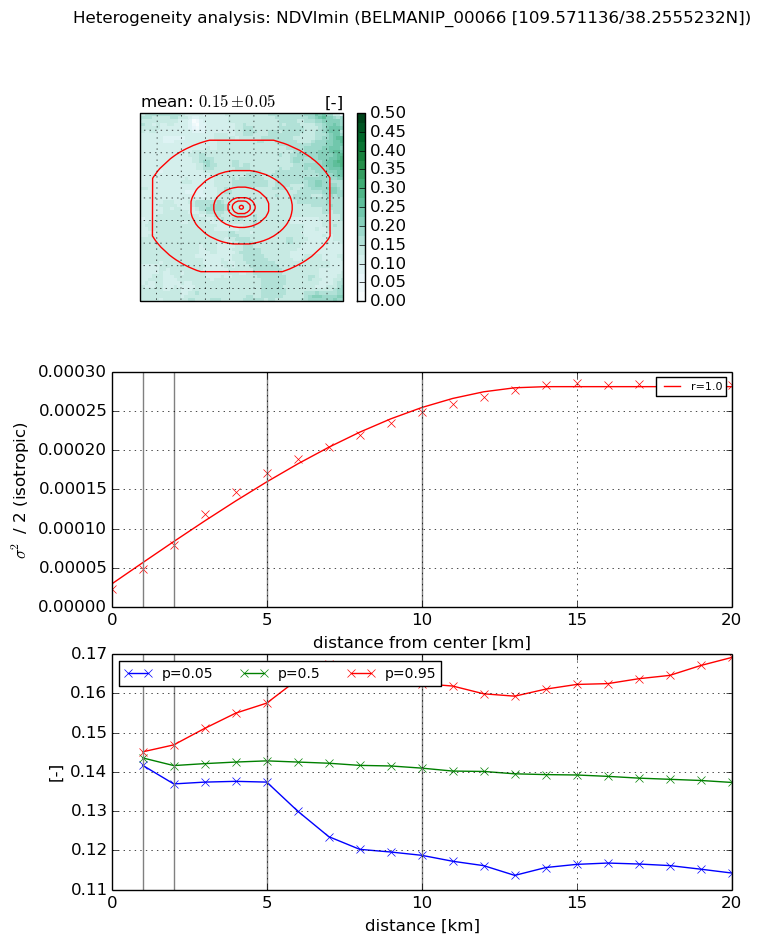
Heterogeneity analysis

The heterogeneity analysis provides information about the spatial and temporal heterogeneity of the site.

Topography


Roman et al. (2009) index


St

0.878489187798

Rcv

3.03026768711

Rse

0.0

Rst

0.000753694589724

Rsv

0.383932429532


Height range @ 1km [m]

36

Height range @ 2km [m]

57

Height range @ 5km [m]

383

Height range @ 10km [m]

-999

Height range @ 20km [m]

-999


Variance slope @ 1 km

3350

Variance slope @ 2 km

3308

Variance slope @ 5 km

2774

Variance slope @ 10 km

-999

Variance slope @ 20 km

-999


NDVI (max. NDVI composite)


Roman et al. (2009) index


St

1.60807676574

Rcv

0.501086611189

Rse

0.0

Rst

-0.364497764306

Rsv

-0.999998203591


NDVI range @ 1km [-]

0.01

NDVI range @ 2km [-]

0.02

NDVI range @ 5km [-]

0.03

NDVI range @ 10km [-]

0.05

NDVI range @ 20km [-]

0.06


Variance slope @ 1 km

2.74245907684e-05

Variance slope @ 2 km

2.94417184478e-05

Variance slope @ 5 km

3.24983071466e-05

Variance slope @ 10 km

2.46169106058e-05

Variance slope @ 20 km

1.35275430829e-05


NDVI (min. NDVI composite)I


Roman et al. (2009) index


St

2.36601935209

Rcv

0.790266013699

Rse

0.0

Rst

-0.20897457043

Rsv

0.268711851403


NDVI range @ 1km [-]

0.0

NDVI range @ 2km [-]

0.01

NDVI range @ 5km [-]

0.02

NDVI range @ 10km [-]

0.04

NDVI range @ 20km [-]

0.05


NDVI slope @ 1 km

2.52931906201e-05

NDVI slope @ 2 km

2.80065077957e-05

NDVI slope @ 5 km

3.07348681154e-05

NDVI slope @ 10 km

2.2796585937e-05

NDVI slope @ 20 km

1.24350185844e-05


Temporal stability analysis

+000 deg (BHR)


BHR statistics

Temporal stability [1/decade]:


abs

rel


Weighted least square:

None


Ordinary least square:

None


Probabilities that GCOS criteria is met:

Weighted least square:

None %

Ordinary least square:

None %


DHR statistics

Temporal stability [1/decade]:


abs

rel


Weighted least square:

None


Ordinary least square:

None


Probabilities that GCOS criteria is met:

Weighted least square:

None %

Ordinary least square:

None %


+057/+063 deg (BHR)


BHR statistics

Temporal stability [1/decade]:


abs

rel


Weighted least square:

None


Ordinary least square:

None


Probabilities that GCOS criteria is met:

Weighted least square:

None %

Ordinary least square:

None %


DHR statistics

Temporal stability [1/decade]:


abs

rel


Weighted least square:

None


Ordinary least square:

None


Probabilities that GCOS criteria is met:

Weighted least square:

None %

Ordinary least square:

None %


Temporal anomaly analyis

The variance of the temporal anomalies provides an additional measure about the stability of the signal AFTER removal of the mean seasonal cylce.

+000 deg


+057/+063 deg