BELMANIP_00109


Location

lon / lat [deg]: -133.501 / 66.0717

Source network: BELMANIP


Geostationary surface albedo (GSA) data


“+000”


“+057/+063”


Landcover information (based on ESA CCI landcover data)


Landcover fractions @ 2km distance


Landcover fractions @ 20 km distance


Legend


Distance to open water bodies [km]:

5.44

Distance to urban areas [km]:

none in region


Radius: 1 km

Number of landcover classes:

4

Dominant landcover type:

100: Mosaic tree and shrub (>50%) / herbaceous cover (<50%)

Fraction of dominant landcover type [%]:

61.0


Radius: 2 km

Number of landcover classes:

4

Dominant landcover type:

100: Mosaic tree and shrub (>50%) / herbaceous cover (<50%)

Fraction of dominant landcover type [%]:

44.0


Radius: 5 km

Number of landcover classes:

5

Dominant landcover type:

150: Sparse vegetation (tree, shrub, herbaceous cover) (<15%)

Fraction of dominant landcover type [%]:

38.0


Radius: 10 km

Number of landcover classes:

6

Dominant landcover type:

150: Sparse vegetation (tree, shrub, herbaceous cover) (<15%)

Fraction of dominant landcover type [%]:

35.0


Radius: 20 km

Number of landcover classes:

7

Dominant landcover type:

150: Sparse vegetation (tree, shrub, herbaceous cover) (<15%)

Fraction of dominant landcover type [%]:

28.0


Disturbances


Heterogeneity analysis

The heterogeneity analysis provides information about the spatial and temporal heterogeneity of the site.

Topography


Roman et al. (2009) index


St

0.00650348880248

Rcv

0.703419028875

Rse

0.0

Rst

3.14958315331e-05

Rsv

460.587418287


Height range @ 1km [m]

8

Height range @ 2km [m]

19

Height range @ 5km [m]

45

Height range @ 10km [m]

-999

Height range @ 20km [m]

-999


Variance slope @ 1 km

24

Variance slope @ 2 km

29

Variance slope @ 5 km

43

Variance slope @ 10 km

-999

Variance slope @ 20 km

-999


NDVI (max. NDVI composite)


Roman et al. (2009) index


St

29.8125169147

Rcv

-0.0178307702871

Rse

0.0

Rst

0.0689812935778

Rsv

0.013816809859


NDVI range @ 1km [-]

0.02

NDVI range @ 2km [-]

0.05

NDVI range @ 5km [-]

0.06

NDVI range @ 10km [-]

0.06

NDVI range @ 20km [-]

0.1


Variance slope @ 1 km

9.08523689987e-05

Variance slope @ 2 km

0.000103087494424

Variance slope @ 5 km

0.000113899947815

Variance slope @ 10 km

7.79101104919e-05

Variance slope @ 20 km

3.39923403407e-05


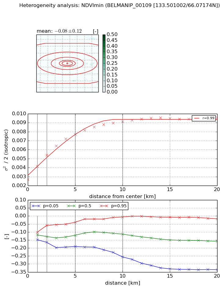
NDVI (min. NDVI composite)I


Roman et al. (2009) index


St

9.5545948524e-07

Rcv

0.251592327762

Rse

0.0

Rst

-0.0760481723834

Rsv

3139850.23258


NDVI range @ 1km [-]

0.05

NDVI range @ 2km [-]

0.11

NDVI range @ 5km [-]

0.15

NDVI range @ 10km [-]

0.25

NDVI range @ 20km [-]

0.32


NDVI slope @ 1 km

0.00145571191441

NDVI slope @ 2 km

0.00135968406358

NDVI slope @ 5 km

0.00101076611121

NDVI slope @ 10 km

0.000608735349836

NDVI slope @ 20 km

0.000263935068046


Temporal stability analysis

+000 deg (BHR)


BHR statistics

Temporal stability [1/decade]:


abs

rel


Weighted least square:

None


Ordinary least square:

None


Probabilities that GCOS criteria is met:

Weighted least square:

None %

Ordinary least square:

None %


DHR statistics

Temporal stability [1/decade]:


abs

rel


Weighted least square:

None


Ordinary least square:

None


Probabilities that GCOS criteria is met:

Weighted least square:

None %

Ordinary least square:

None %


+057/+063 deg (BHR)


BHR statistics

Temporal stability [1/decade]:


abs

rel


Weighted least square:

None


Ordinary least square:

None


Probabilities that GCOS criteria is met:

Weighted least square:

None %

Ordinary least square:

None %


DHR statistics

Temporal stability [1/decade]:


abs

rel


Weighted least square:

None


Ordinary least square:

None


Probabilities that GCOS criteria is met:

Weighted least square:

None %

Ordinary least square:

None %


Temporal anomaly analyis

The variance of the temporal anomalies provides an additional measure about the stability of the signal AFTER removal of the mean seasonal cylce.

+000 deg


+057/+063 deg