BELMANIP_00125


Location

lon / lat [deg]: 45.8077 / -22.1923

Source network: BELMANIP


Geostationary surface albedo (GSA) data


“+000”


“+057/+063”


Landcover information (based on ESA CCI landcover data)


Landcover fractions @ 2km distance


Landcover fractions @ 20 km distance


Legend


Distance to open water bodies [km]:

29.18

Distance to urban areas [km]:

38.6


Radius: 1 km

Number of landcover classes:

1

Dominant landcover type:

130: grassland

Fraction of dominant landcover type [%]:

100.0


Radius: 2 km

Number of landcover classes:

1

Dominant landcover type:

130: grassland

Fraction of dominant landcover type [%]:

100.0


Radius: 5 km

Number of landcover classes:

3

Dominant landcover type:

130: grassland

Fraction of dominant landcover type [%]:

93.0


Radius: 10 km

Number of landcover classes:

3

Dominant landcover type:

130: grassland

Fraction of dominant landcover type [%]:

93.0


Radius: 20 km

Number of landcover classes:

2

Dominant landcover type:

130: grassland

Fraction of dominant landcover type [%]:

97.0


Disturbances


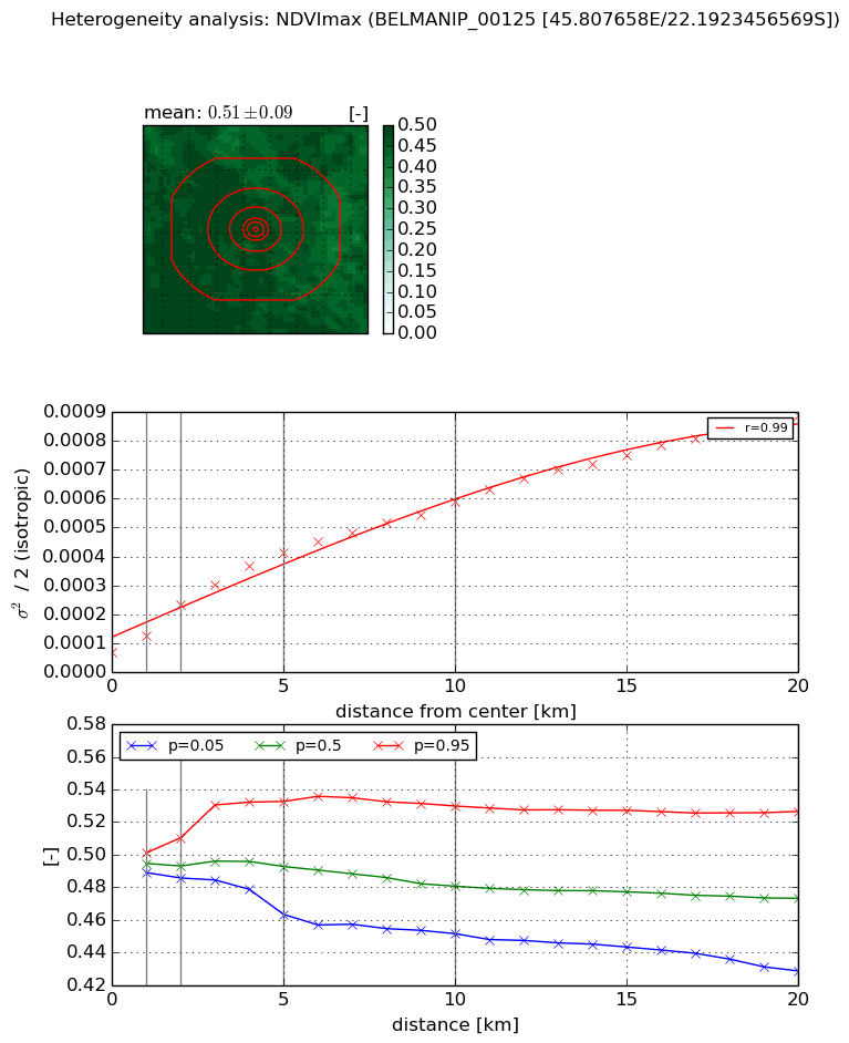
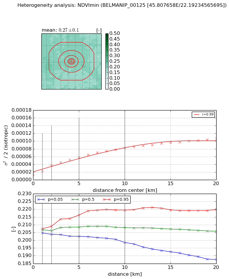
Heterogeneity analysis

The heterogeneity analysis provides information about the spatial and temporal heterogeneity of the site.

Topography


Roman et al. (2009) index


St

6.44699140176e-05

Rcv

0.914800974029

Rse

0.0

Rst

0.0635369437431

Rsv

46532.3550117


Height range @ 1km [m]

46

Height range @ 2km [m]

104

Height range @ 5km [m]

277

Height range @ 10km [m]

-999

Height range @ 20km [m]

-999


Variance slope @ 1 km

1572

Variance slope @ 2 km

1729

Variance slope @ 5 km

1623

Variance slope @ 10 km

-999

Variance slope @ 20 km

-999


NDVI (max. NDVI composite)


Roman et al. (2009) index


St

2.24063161177

Rcv

0.641779847809

Rse

0.0

Rst

-3.96020233819e-09

Rsv

0.697128331192


NDVI range @ 1km [-]

0.01

NDVI range @ 2km [-]

0.02

NDVI range @ 5km [-]

0.07

NDVI range @ 10km [-]

0.08

NDVI range @ 20km [-]

0.1


Variance slope @ 1 km

5.7690513949e-05

Variance slope @ 2 km

8.22421854006e-05

Variance slope @ 5 km

7.13203491586e-05

Variance slope @ 10 km

5.05226089916e-05

Variance slope @ 20 km

3.80440241767e-05


NDVI (min. NDVI composite)I


Roman et al. (2009) index


St

1.70384262646

Rcv

0.427095193507

Rse

0.0

Rst

-0.417973905732

Rsv

0.915656893534


NDVI range @ 1km [-]

0.0

NDVI range @ 2km [-]

0.01

NDVI range @ 5km [-]

0.01

NDVI range @ 10km [-]

0.02

NDVI range @ 20km [-]

0.03


NDVI slope @ 1 km

9.24879922419e-06

NDVI slope @ 2 km

1.20728206331e-05

NDVI slope @ 5 km

9.07494646999e-06

NDVI slope @ 10 km

6.75037534057e-06

NDVI slope @ 20 km

4.21432815013e-06


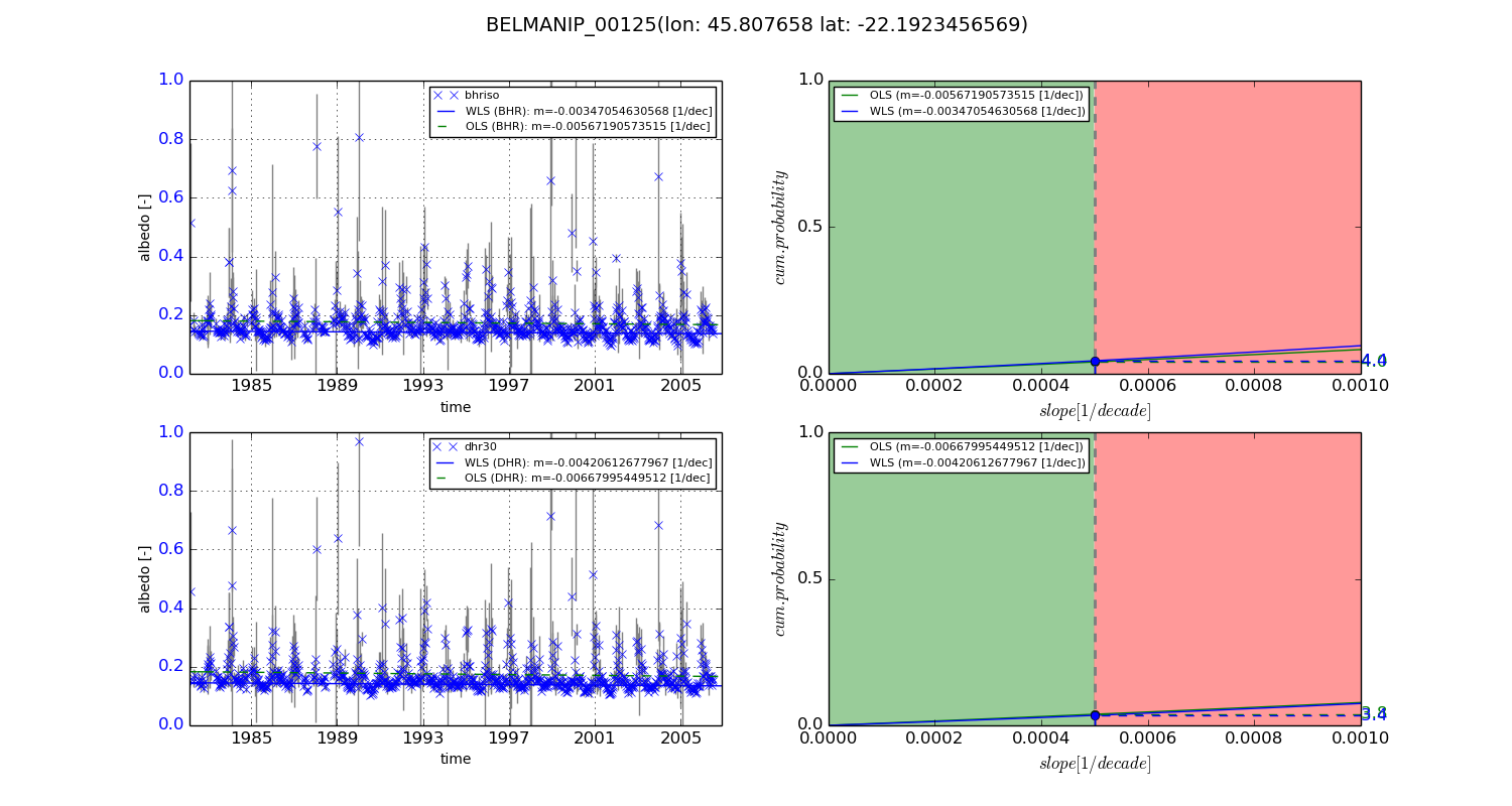
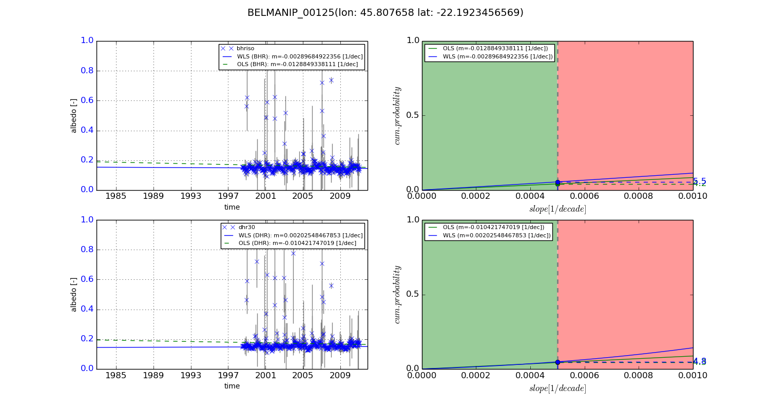
Temporal stability analysis

+000 deg (BHR)


BHR statistics

Temporal stability [1/decade]:


abs

rel


Weighted least square:

-0.00347054630568


Ordinary least square:

-0.00567190573515


Probabilities that GCOS criteria is met:

Weighted least square:

4.4 %

Ordinary least square:

4.0 %


DHR statistics

Temporal stability [1/decade]:


abs

rel


Weighted least square:

-0.00420612677967


Ordinary least square:

-0.00667995449512


Probabilities that GCOS criteria is met:

Weighted least square:

3.4 %

Ordinary least square:

3.8 %


+057/+063 deg (BHR)


BHR statistics

Temporal stability [1/decade]:


abs

rel


Weighted least square:

-0.00289684922356


Ordinary least square:

-0.0128849338111


Probabilities that GCOS criteria is met:

Weighted least square:

5.5 %

Ordinary least square:

4.2 %


DHR statistics

Temporal stability [1/decade]:


abs

rel


Weighted least square:

0.00202548467853


Ordinary least square:

-0.010421747019


Probabilities that GCOS criteria is met:

Weighted least square:

4.8 %

Ordinary least square:

4.3 %


Temporal anomaly analyis

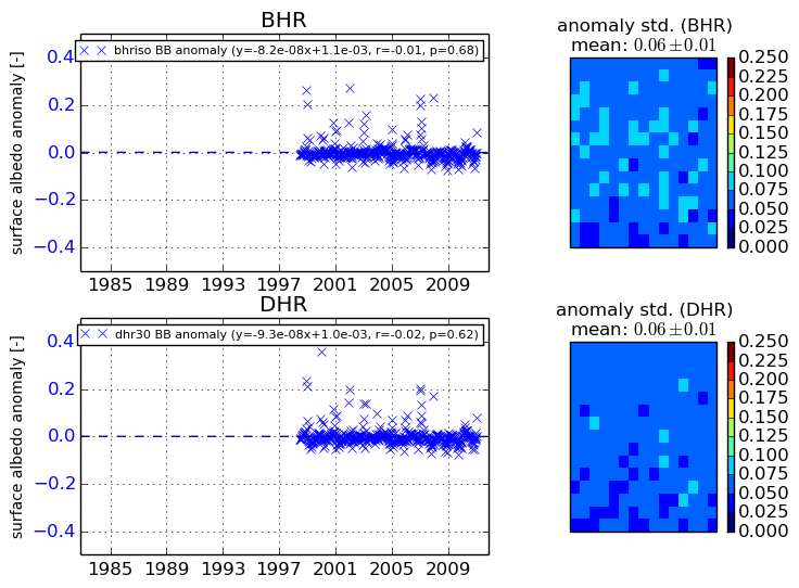
The variance of the temporal anomalies provides an additional measure about the stability of the signal AFTER removal of the mean seasonal cylce.
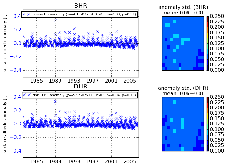
+000 deg


+057/+063 deg