BELMANIP_00186


Location

lon / lat [deg]: 39.4063 / 10.6991

Source network: BELMANIP


Geostationary surface albedo (GSA) data


“+000”


“+057/+063”


Landcover information (based on ESA CCI landcover data)


Landcover fractions @ 2km distance


Landcover fractions @ 20 km distance


Legend


Distance to open water bodies [km]:

41.38

Distance to urban areas [km]:

11.26


Radius: 1 km

Number of landcover classes:

2

Dominant landcover type:

10: cropland, rainfed

Fraction of dominant landcover type [%]:

97.0


Radius: 2 km

Number of landcover classes:

2

Dominant landcover type:

10: cropland, rainfed

Fraction of dominant landcover type [%]:

97.0


Radius: 5 km

Number of landcover classes:

3

Dominant landcover type:

10: cropland, rainfed

Fraction of dominant landcover type [%]:

95.0


Radius: 10 km

Number of landcover classes:

5

Dominant landcover type:

10: cropland, rainfed

Fraction of dominant landcover type [%]:

87.0


Radius: 20 km

Number of landcover classes:

4

Dominant landcover type:

10: cropland, rainfed

Fraction of dominant landcover type [%]:

89.0


Disturbances


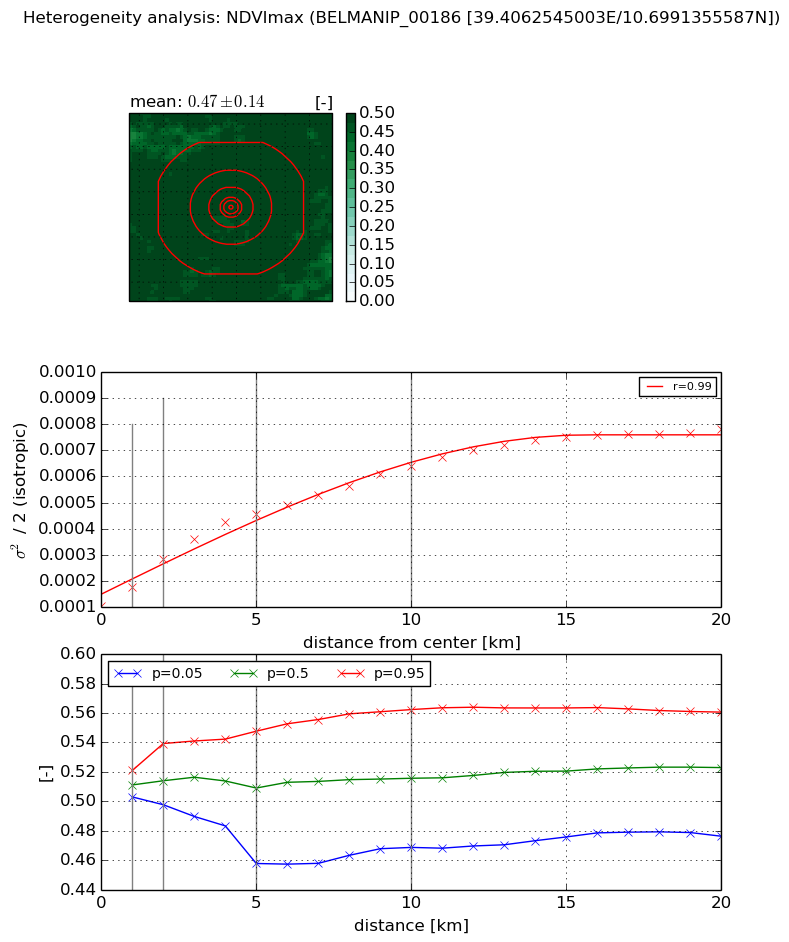
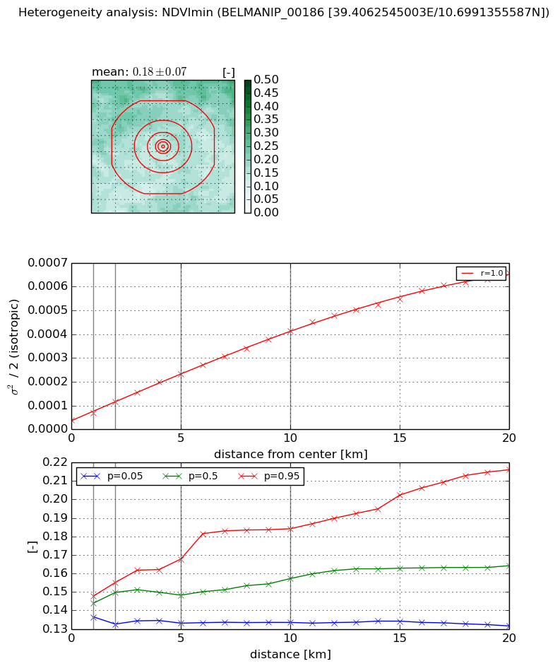
Heterogeneity analysis

The heterogeneity analysis provides information about the spatial and temporal heterogeneity of the site.

Topography


Roman et al. (2009) index


St

0.00121795735833

Rcv

0.995007258381

Rse

0.0

Rst

-0.0999698542924

Rsv

2462.04544359


Height range @ 1km [m]

22

Height range @ 2km [m]

77

Height range @ 5km [m]

172

Height range @ 10km [m]

-999

Height range @ 20km [m]

-999


Variance slope @ 1 km

2840

Variance slope @ 2 km

1748

Variance slope @ 5 km

948

Variance slope @ 10 km

-999

Variance slope @ 20 km

-999


NDVI (max. NDVI composite)


Roman et al. (2009) index


St

nan

Rcv

nan

Rse

nan

Rst

nan

Rsv

nan


NDVI range @ 1km [-]

0.02

NDVI range @ 2km [-]

0.04

NDVI range @ 5km [-]

0.09

NDVI range @ 10km [-]

0.09

NDVI range @ 20km [-]

0.08


Variance slope @ 1 km

7.18654746662e-05

Variance slope @ 2 km

8.98259331906e-05

Variance slope @ 5 km

7.4225355597e-05

Variance slope @ 10 km

5.14924261457e-05

Variance slope @ 20 km

3.13277121707e-05


NDVI (min. NDVI composite)I


Roman et al. (2009) index


St

1.64348773505

Rcv

0.282583196021

Rse

0.0

Rst

-0.542803556498

Rsv

-0.999999550053


NDVI range @ 1km [-]

0.01

NDVI range @ 2km [-]

0.02

NDVI range @ 5km [-]

0.03

NDVI range @ 10km [-]

0.05

NDVI range @ 20km [-]

0.08


NDVI slope @ 1 km

2.99208591172e-05

NDVI slope @ 2 km

3.85964613635e-05

NDVI slope @ 5 km

4.01166341948e-05

NDVI slope @ 10 km

3.78946580479e-05

NDVI slope @ 20 km

3.15414098268e-05


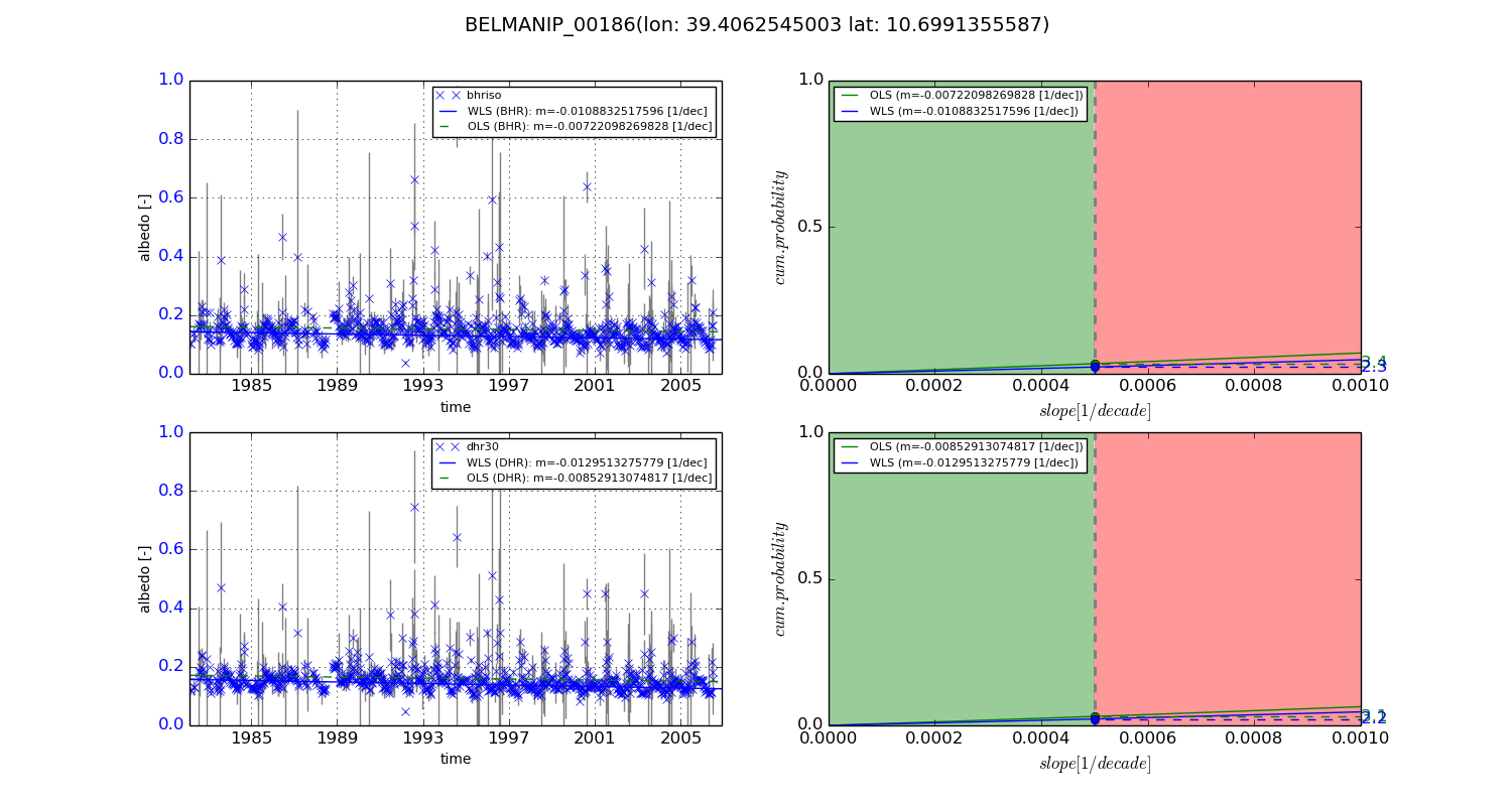
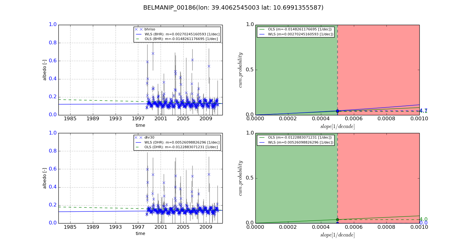
Temporal stability analysis

+000 deg (BHR)


BHR statistics

Temporal stability [1/decade]:


abs

rel


Weighted least square:

-0.0108832517596


Ordinary least square:

-0.00722098269828


Probabilities that GCOS criteria is met:

Weighted least square:

2.3 %

Ordinary least square:

3.4 %


DHR statistics

Temporal stability [1/decade]:


abs

rel


Weighted least square:

-0.0129513275779


Ordinary least square:

-0.00852913074817


Probabilities that GCOS criteria is met:

Weighted least square:

2.2 %

Ordinary least square:

3.1 %


+057/+063 deg (BHR)


BHR statistics

Temporal stability [1/decade]:


abs

rel


Weighted least square:

0.00270245160593


Ordinary least square:

-0.0148261176695


Probabilities that GCOS criteria is met:

Weighted least square:

4.7 %

Ordinary least square:

4.1 %


DHR statistics

Temporal stability [1/decade]:


abs

rel


Weighted least square:

0.00526098826296


Ordinary least square:

-0.0122883071231


Probabilities that GCOS criteria is met:

Weighted least square:

0.0 %

Ordinary least square:

4.0 %


Temporal anomaly analyis

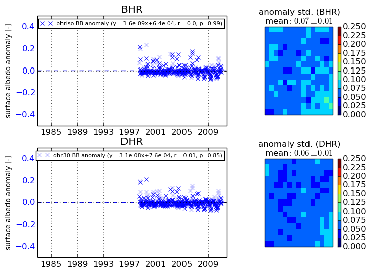
The variance of the temporal anomalies provides an additional measure about the stability of the signal AFTER removal of the mean seasonal cylce.
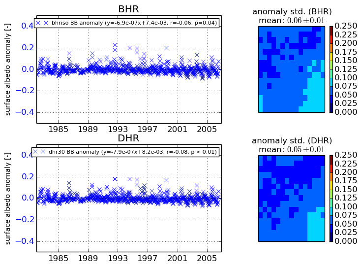
+000 deg


+057/+063 deg