BELMANIP_00201


Location

lon / lat [deg]: -4.147 / 29.8195

Source network: BELMANIP


Geostationary surface albedo (GSA) data


“+000”


“+057/+063”


Landcover information (based on ESA CCI landcover data)


Landcover fractions @ 2km distance


Landcover fractions @ 20 km distance


Legend


Distance to open water bodies [km]:

12.9

Distance to urban areas [km]:

23.01


Radius: 1 km

Number of landcover classes:

1

Dominant landcover type:

200: bare areas

Fraction of dominant landcover type [%]:

100.0


Radius: 2 km

Number of landcover classes:

1

Dominant landcover type:

200: bare areas

Fraction of dominant landcover type [%]:

100.0


Radius: 5 km

Number of landcover classes:

1

Dominant landcover type:

200: bare areas

Fraction of dominant landcover type [%]:

100.0


Radius: 10 km

Number of landcover classes:

1

Dominant landcover type:

200: bare areas

Fraction of dominant landcover type [%]:

100.0


Radius: 20 km

Number of landcover classes:

1

Dominant landcover type:

200: bare areas

Fraction of dominant landcover type [%]:

99.0


Disturbances


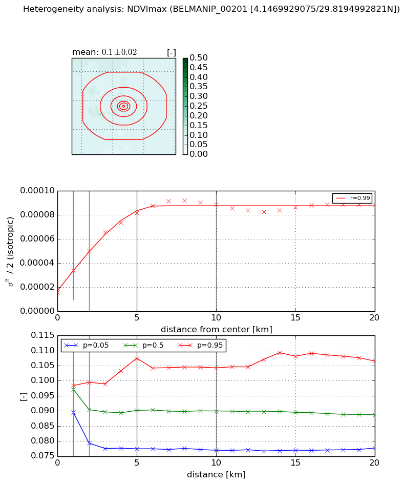
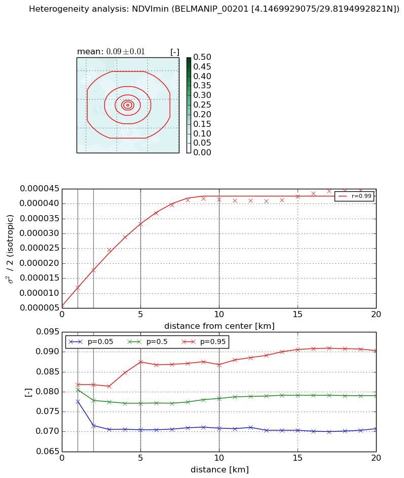
Heterogeneity analysis

The heterogeneity analysis provides information about the spatial and temporal heterogeneity of the site.

Topography


Roman et al. (2009) index


St

6.31966840797

Rcv

0.0737346861696

Rse

0.0

Rst

2.92434097474e-06

Rsv

-0.400970840366


Height range @ 1km [m]

37

Height range @ 2km [m]

48

Height range @ 5km [m]

57

Height range @ 10km [m]

-999

Height range @ 20km [m]

-999


Variance slope @ 1 km

59

Variance slope @ 2 km

61

Variance slope @ 5 km

86

Variance slope @ 10 km

-999

Variance slope @ 20 km

-999


NDVI (max. NDVI composite)


Roman et al. (2009) index


St

5.55559797645

Rcv

0.302556487321

Rse

0.0

Rst

-0.194483624875

Rsv

-0.0429557645249


NDVI range @ 1km [-]

0.01

NDVI range @ 2km [-]

0.02

NDVI range @ 5km [-]

0.03

NDVI range @ 10km [-]

0.03

NDVI range @ 20km [-]

0.03


Variance slope @ 1 km

1.84588177056e-05

Variance slope @ 2 km

1.71765924647e-05

Variance slope @ 5 km

1.32772277321e-05

Variance slope @ 10 km

7.07938256179e-06

Variance slope @ 20 km

2.244023391e-06


NDVI (min. NDVI composite)I


Roman et al. (2009) index


St

1.67444062584

Rcv

0.527907366717

Rse

0.0

Rst

-0.263736238373

Rsv

-0.99999949871


NDVI range @ 1km [-]

0.0

NDVI range @ 2km [-]

0.01

NDVI range @ 5km [-]

0.02

NDVI range @ 10km [-]

0.02

NDVI range @ 20km [-]

0.02


NDVI slope @ 1 km

6.53311146822e-06

NDVI slope @ 2 km

6.30304643333e-06

NDVI slope @ 5 km

5.64564534873e-06

NDVI slope @ 10 km

3.71806156874e-06

NDVI slope @ 20 km

1.54832438357e-06


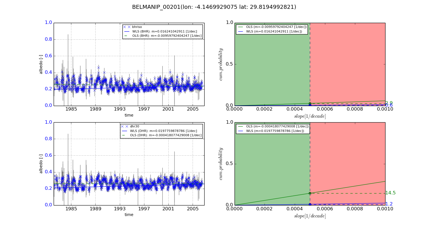
Temporal stability analysis

+000 deg (BHR)


BHR statistics

Temporal stability [1/decade]:


abs

rel


Weighted least square:

0.016241042911


Ordinary least square:

-0.00959792404247


Probabilities that GCOS criteria is met:

Weighted least square:

0.6 %

Ordinary least square:

2.9 %


DHR statistics

Temporal stability [1/decade]:


abs

rel


Weighted least square:

0.0197759878786


Ordinary least square:

-0.000418077429008


Probabilities that GCOS criteria is met:

Weighted least square:

1.2 %

Ordinary least square:

14.5 %


+057/+063 deg (BHR)


BHR statistics

Temporal stability [1/decade]:


abs

rel


Weighted least square:

-99999.0


Ordinary least square:

-99999.0


Probabilities that GCOS criteria is met:

Weighted least square:

-99999.0 %

Ordinary least square:

-99999.0 %


DHR statistics

Temporal stability [1/decade]:


abs

rel


Weighted least square:

-99999.0


Ordinary least square:

-99999.0


Probabilities that GCOS criteria is met:

Weighted least square:

-99999.0 %

Ordinary least square:

-99999.0 %


Temporal anomaly analyis

The variance of the temporal anomalies provides an additional measure about the stability of the signal AFTER removal of the mean seasonal cylce.
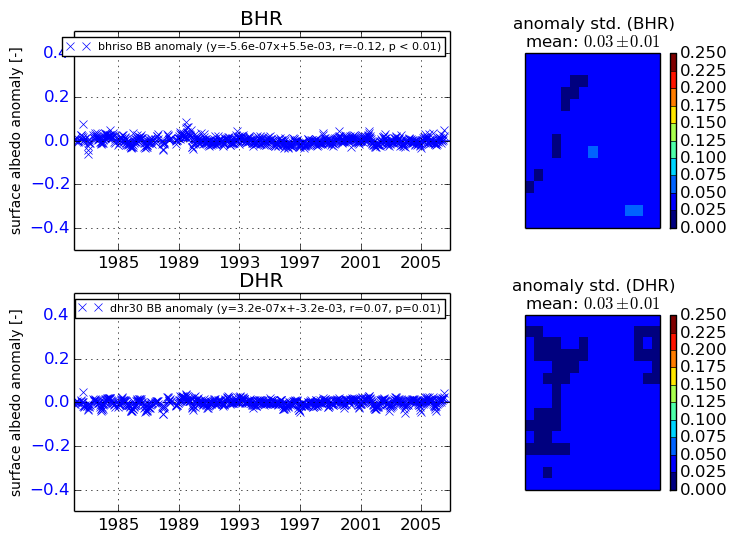
+000 deg


+057/+063 deg