BELMANIP_00219


Location

lon / lat [deg]: 5.2089 / 26.1144

Source network: BELMANIP


Geostationary surface albedo (GSA) data


“+000”


“+057/+063”


Landcover information (based on ESA CCI landcover data)


Landcover fractions @ 2km distance


Landcover fractions @ 20 km distance


Legend


Distance to open water bodies [km]:

none in region

Distance to urban areas [km]:

none in region


Radius: 1 km

Number of landcover classes:

1

Dominant landcover type:

200: bare areas

Fraction of dominant landcover type [%]:

100.0


Radius: 2 km

Number of landcover classes:

1

Dominant landcover type:

200: bare areas

Fraction of dominant landcover type [%]:

100.0


Radius: 5 km

Number of landcover classes:

1

Dominant landcover type:

200: bare areas

Fraction of dominant landcover type [%]:

100.0


Radius: 10 km

Number of landcover classes:

1

Dominant landcover type:

200: bare areas

Fraction of dominant landcover type [%]:

100.0


Radius: 20 km

Number of landcover classes:

1

Dominant landcover type:

200: bare areas

Fraction of dominant landcover type [%]:

100.0


Disturbances


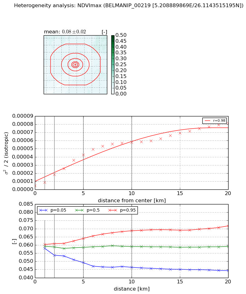
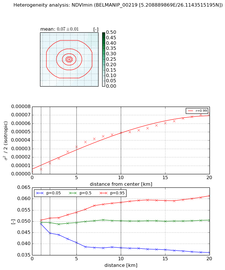
Heterogeneity analysis

The heterogeneity analysis provides information about the spatial and temporal heterogeneity of the site.

Topography


Roman et al. (2009) index


St

2.35237241119

Rcv

0.640743779824

Rse

0.0

Rst

0.0580713860682

Rsv

0.576493108313


Height range @ 1km [m]

9

Height range @ 2km [m]

14

Height range @ 5km [m]

31

Height range @ 10km [m]

-999

Height range @ 20km [m]

-999


Variance slope @ 1 km

24

Variance slope @ 2 km

23

Variance slope @ 5 km

20

Variance slope @ 10 km

-999

Variance slope @ 20 km

-999


NDVI (max. NDVI composite)


Roman et al. (2009) index


St

1.48764275668

Rcv

0.726364110652

Rse

0.0

Rst

-0.290249962915

Rsv

-0.999999112988


NDVI range @ 1km [-]

0.0

NDVI range @ 2km [-]

0.01

NDVI range @ 5km [-]

0.01

NDVI range @ 10km [-]

0.02

NDVI range @ 20km [-]

0.03


Variance slope @ 1 km

4.30006341417e-06

Variance slope @ 2 km

7.04987386614e-06

Variance slope @ 5 km

7.98187181447e-06

Variance slope @ 10 km

5.81954405988e-06

Variance slope @ 20 km

3.45588500714e-06


NDVI (min. NDVI composite)I


Roman et al. (2009) index


St

1.62390413728

Rcv

0.645410980979

Rse

0.0

Rst

-0.201989220938

Rsv

-0.999999488205


NDVI range @ 1km [-]

0.0

NDVI range @ 2km [-]

0.01

NDVI range @ 5km [-]

0.01

NDVI range @ 10km [-]

0.02

NDVI range @ 20km [-]

0.03


NDVI slope @ 1 km

2.95907293375e-06

NDVI slope @ 2 km

5.00803644542e-06

NDVI slope @ 5 km

6.11839852127e-06

NDVI slope @ 10 km

4.99518292717e-06

NDVI slope @ 20 km

3.2971983254e-06


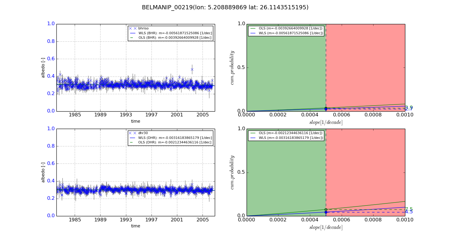
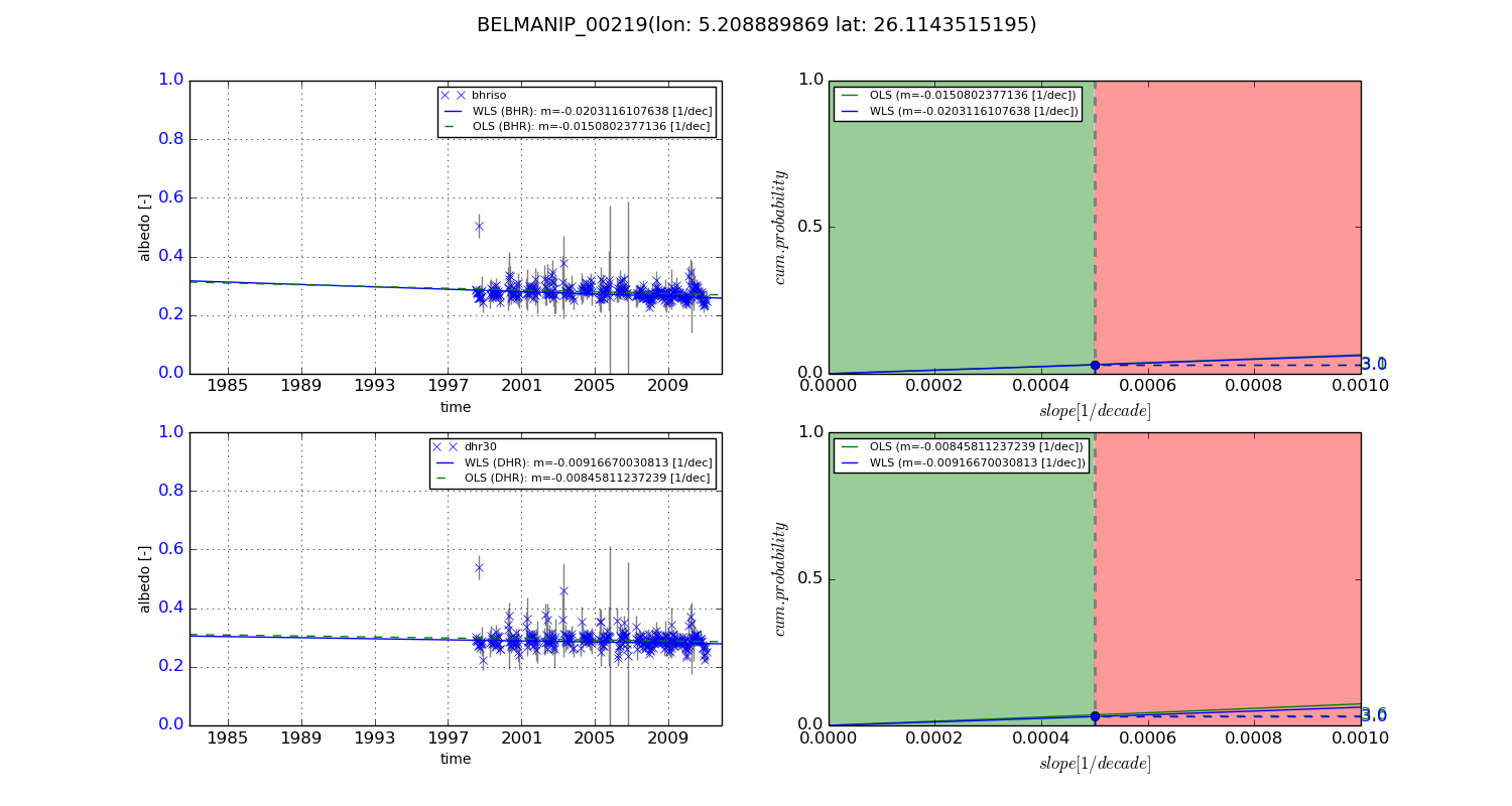
Temporal stability analysis

+000 deg (BHR)


BHR statistics

Temporal stability [1/decade]:


abs

rel


Weighted least square:

-0.00561871525086


Ordinary least square:

-0.00392664009928


Probabilities that GCOS criteria is met:

Weighted least square:

2.7 %

Ordinary least square:

3.9 %


DHR statistics

Temporal stability [1/decade]:


abs

rel


Weighted least square:

-0.00316183865179


Ordinary least square:

-0.00212344636116


Probabilities that GCOS criteria is met:

Weighted least square:

4.5 %

Ordinary least square:

7.5 %


+057/+063 deg (BHR)


BHR statistics

Temporal stability [1/decade]:


abs

rel


Weighted least square:

-0.0203116107638


Ordinary least square:

-0.0150802377136


Probabilities that GCOS criteria is met:

Weighted least square:

3.0 %

Ordinary least square:

3.1 %


DHR statistics

Temporal stability [1/decade]:


abs

rel


Weighted least square:

-0.00916670030813


Ordinary least square:

-0.00845811237239


Probabilities that GCOS criteria is met:

Weighted least square:

3.0 %

Ordinary least square:

3.6 %


Temporal anomaly analyis

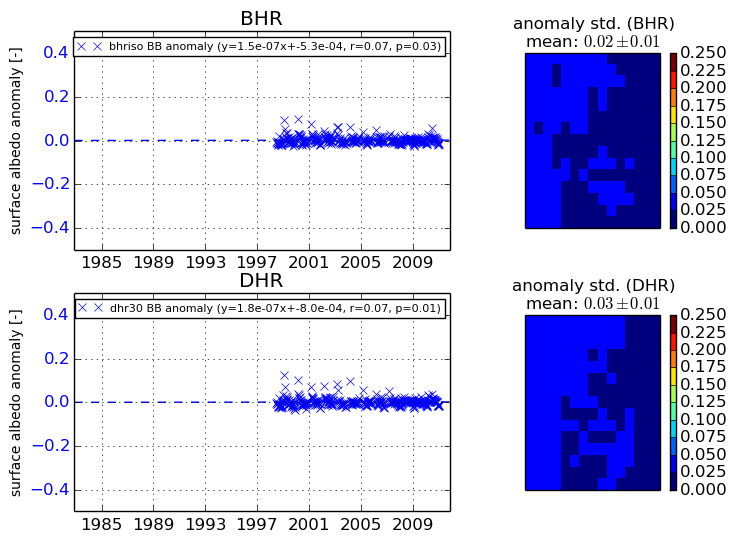
The variance of the temporal anomalies provides an additional measure about the stability of the signal AFTER removal of the mean seasonal cylce.
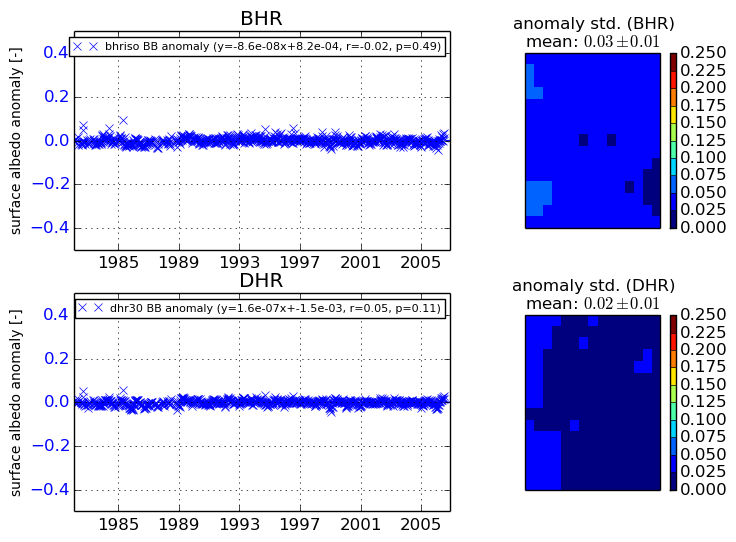
+000 deg


+057/+063 deg