BELMANIP_00246


Location

lon / lat [deg]: 49.5687 / 48.3274

Source network: BELMANIP


Geostationary surface albedo (GSA) data


“+000”


“+057/+063”


Landcover information (based on ESA CCI landcover data)


Landcover fractions @ 2km distance


Landcover fractions @ 20 km distance


Legend


Distance to open water bodies [km]:

44.23

Distance to urban areas [km]:

none in region


Radius: 1 km

Number of landcover classes:

1

Dominant landcover type:

130: grassland

Fraction of dominant landcover type [%]:

100.0


Radius: 2 km

Number of landcover classes:

1

Dominant landcover type:

130: grassland

Fraction of dominant landcover type [%]:

100.0


Radius: 5 km

Number of landcover classes:

2

Dominant landcover type:

130: grassland

Fraction of dominant landcover type [%]:

91.0


Radius: 10 km

Number of landcover classes:

2

Dominant landcover type:

130: grassland

Fraction of dominant landcover type [%]:

95.0


Radius: 20 km

Number of landcover classes:

2

Dominant landcover type:

130: grassland

Fraction of dominant landcover type [%]:

96.0


Disturbances


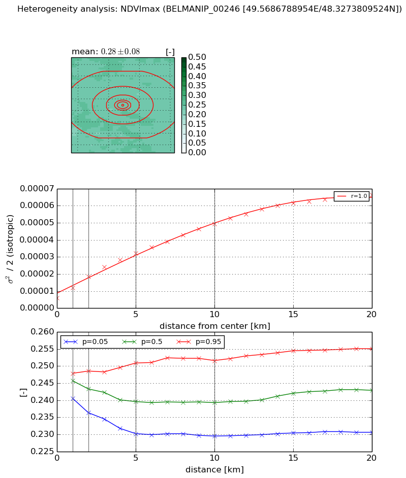
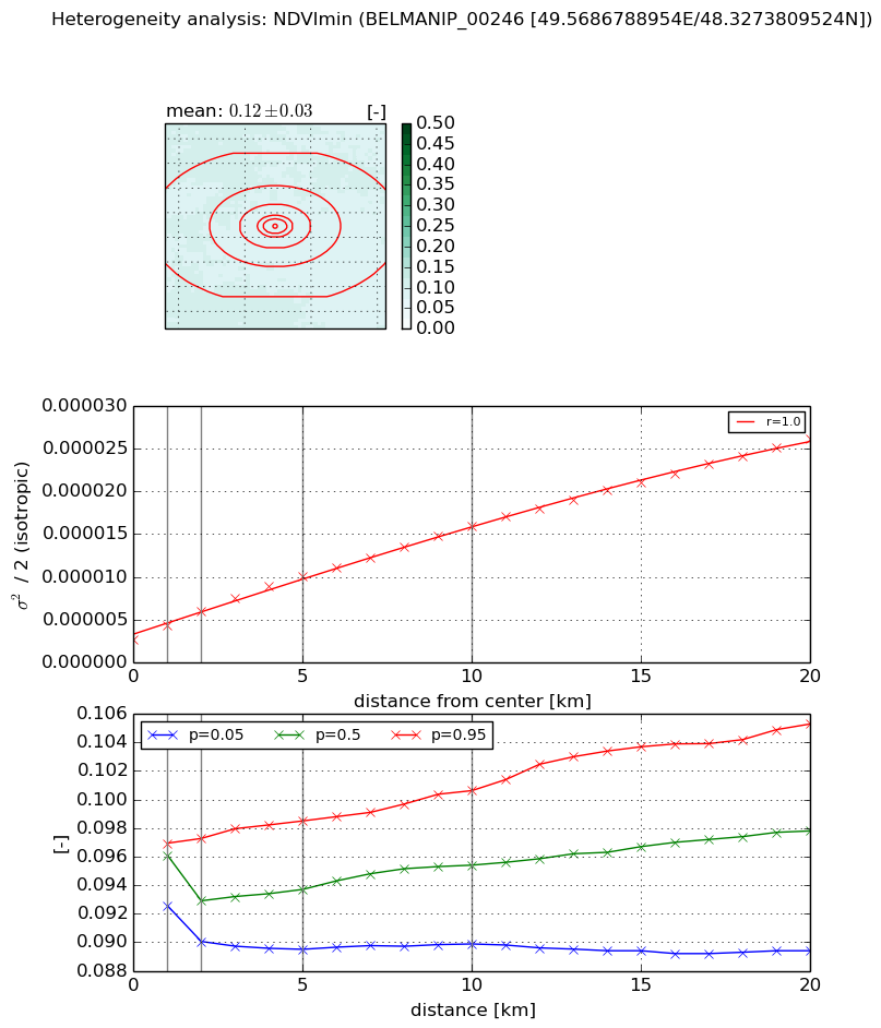
Heterogeneity analysis

The heterogeneity analysis provides information about the spatial and temporal heterogeneity of the site.

Topography


Roman et al. (2009) index


St

nan

Rcv

nan

Rse

nan

Rst

nan

Rsv

nan


Height range @ 1km [m]

-99999

Height range @ 2km [m]

-99999

Height range @ 5km [m]

-99999

Height range @ 10km [m]

-99999

Height range @ 20km [m]

-99999


Variance slope @ 1 km

-999

Variance slope @ 2 km

-999

Variance slope @ 5 km

-999

Variance slope @ 10 km

-999

Variance slope @ 20 km

-999


NDVI (max. NDVI composite)


Roman et al. (2009) index


St

2.19574212834

Rcv

0.451747877921

Rse

0.0

Rst

-0.125194828534

Rsv

0.789337951585


NDVI range @ 1km [-]

0.01

NDVI range @ 2km [-]

0.01

NDVI range @ 5km [-]

0.02

NDVI range @ 10km [-]

0.02

NDVI range @ 20km [-]

0.02


Variance slope @ 1 km

5.95470537548e-06

Variance slope @ 2 km

6.15864325867e-06

Variance slope @ 5 km

5.29172370093e-06

Variance slope @ 10 km

4.23278762035e-06

Variance slope @ 20 km

2.9479517573e-06


NDVI (min. NDVI composite)I


Roman et al. (2009) index


St

3.23725923269

Rcv

0.098908053934

Rse

0.0

Rst

-0.181005722246

Rsv

0.646796068279


NDVI range @ 1km [-]

0.0

NDVI range @ 2km [-]

0.01

NDVI range @ 5km [-]

0.01

NDVI range @ 10km [-]

0.01

NDVI range @ 20km [-]

0.02


NDVI slope @ 1 km

1.62468306972e-06

NDVI slope @ 2 km

1.60690032716e-06

NDVI slope @ 5 km

1.48667616887e-06

NDVI slope @ 10 km

1.28964167695e-06

NDVI slope @ 20 km

1.14019857032e-06


Temporal stability analysis

+000 deg (BHR)


BHR statistics

Temporal stability [1/decade]:


abs

rel


Weighted least square:

-99999.0


Ordinary least square:

-99999.0


Probabilities that GCOS criteria is met:

Weighted least square:

-99999.0 %

Ordinary least square:

-99999.0 %


DHR statistics

Temporal stability [1/decade]:


abs

rel


Weighted least square:

-99999.0


Ordinary least square:

-99999.0


Probabilities that GCOS criteria is met:

Weighted least square:

-99999.0 %

Ordinary least square:

-99999.0 %


+057/+063 deg (BHR)


BHR statistics

Temporal stability [1/decade]:


abs

rel


Weighted least square:

-0.00130709649305


Ordinary least square:

0.00601707561277


Probabilities that GCOS criteria is met:

Weighted least square:

6.8 %

Ordinary least square:

3.9 %


DHR statistics

Temporal stability [1/decade]:


abs

rel


Weighted least square:

0.0115259623844


Ordinary least square:

0.00970737208017


Probabilities that GCOS criteria is met:

Weighted least square:

0.0 %

Ordinary least square:

1.2 %


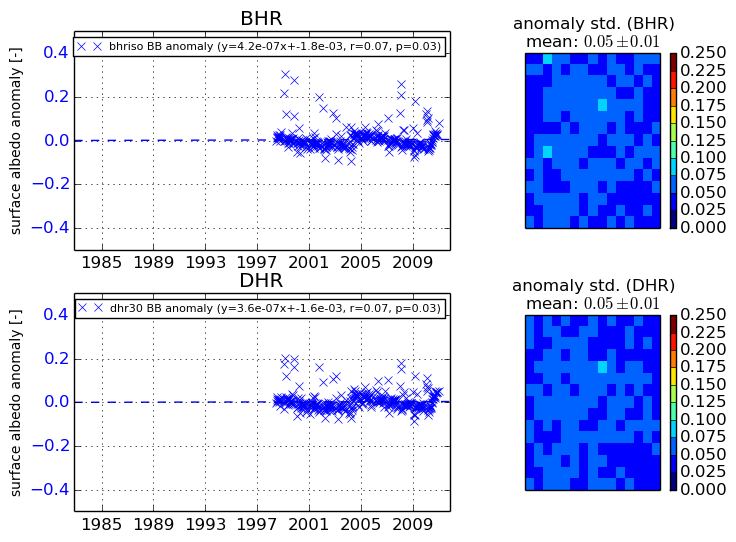
Temporal anomaly analyis

The variance of the temporal anomalies provides an additional measure about the stability of the signal AFTER removal of the mean seasonal cylce.
+000 deg


+057/+063 deg