BELMANIP_00318


Location

lon / lat [deg]: 105.679 / 10.7219

Source network: BELMANIP


Geostationary surface albedo (GSA) data


“+000”


“+057/+063”


Landcover information (based on ESA CCI landcover data)


Landcover fractions @ 2km distance


Landcover fractions @ 20 km distance


Legend


Distance to open water bodies [km]:

13.01

Distance to urban areas [km]:

16.88


Radius: 1 km

Number of landcover classes:

1

Dominant landcover type:

20: cropland, irrigated or post-flooded

Fraction of dominant landcover type [%]:

100.0


Radius: 2 km

Number of landcover classes:

1

Dominant landcover type:

20: cropland, irrigated or post-flooded

Fraction of dominant landcover type [%]:

100.0


Radius: 5 km

Number of landcover classes:

1

Dominant landcover type:

20: cropland, irrigated or post-flooded

Fraction of dominant landcover type [%]:

99.0


Radius: 10 km

Number of landcover classes:

6

Dominant landcover type:

20: cropland, irrigated or post-flooded

Fraction of dominant landcover type [%]:

88.0


Radius: 20 km

Number of landcover classes:

6

Dominant landcover type:

20: cropland, irrigated or post-flooded

Fraction of dominant landcover type [%]:

84.0


Disturbances


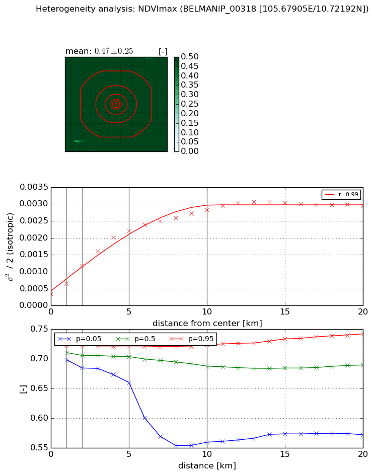
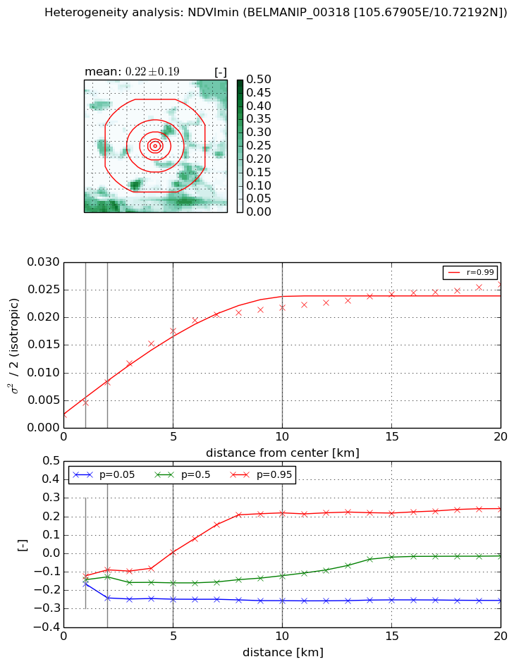
Heterogeneity analysis

The heterogeneity analysis provides information about the spatial and temporal heterogeneity of the site.

Topography


Roman et al. (2009) index


St

54.2984249086

Rcv

-0.0159368428865

Rse

0.0

Rst

0.0391208243318

Rsv

0.000192554220851


Height range @ 1km [m]

4

Height range @ 2km [m]

4

Height range @ 5km [m]

5

Height range @ 10km [m]

-999

Height range @ 20km [m]

-999


Variance slope @ 1 km

0

Variance slope @ 2 km

0

Variance slope @ 5 km

0

Variance slope @ 10 km

-999

Variance slope @ 20 km

-999


NDVI (max. NDVI composite)


Roman et al. (2009) index


St

1.09891547231

Rcv

1.33271455591

Rse

0.0

Rst

-0.397249982864

Rsv

-0.999999753833


NDVI range @ 1km [-]

0.02

NDVI range @ 2km [-]

0.04

NDVI range @ 5km [-]

0.06

NDVI range @ 10km [-]

0.16

NDVI range @ 20km [-]

0.17


Variance slope @ 1 km

0.00031246971787

Variance slope @ 2 km

0.000417669801358

Variance slope @ 5 km

0.000397226523313

Variance slope @ 10 km

0.000246869552771

Variance slope @ 20 km

0.00011244158073


NDVI (min. NDVI composite)I


Roman et al. (2009) index


St

1.15760653224

Rcv

1.04634738373

Rse

0.0

Rst

-0.545207111385

Rsv

-0.999999643914


NDVI range @ 1km [-]

0.04

NDVI range @ 2km [-]

0.15

NDVI range @ 5km [-]

0.26

NDVI range @ 10km [-]

0.48

NDVI range @ 20km [-]

0.5


NDVI slope @ 1 km

0.00216444733263

NDVI slope @ 2 km

0.00297039358769

NDVI slope @ 5 km

0.00319056514545

NDVI slope @ 10 km

0.00204156928347

NDVI slope @ 20 km

0.000995095099563


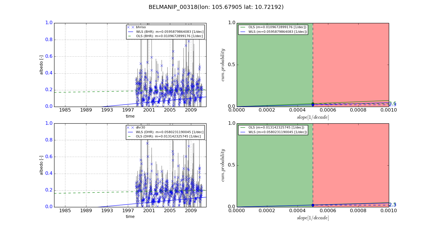
Temporal stability analysis

+000 deg (BHR)


BHR statistics

Temporal stability [1/decade]:


abs

rel


Weighted least square:

None


Ordinary least square:

None


Probabilities that GCOS criteria is met:

Weighted least square:

None %

Ordinary least square:

None %


DHR statistics

Temporal stability [1/decade]:


abs

rel


Weighted least square:

None


Ordinary least square:

None


Probabilities that GCOS criteria is met:

Weighted least square:

None %

Ordinary least square:

None %


+057/+063 deg (BHR)


BHR statistics

Temporal stability [1/decade]:


abs

rel


Weighted least square:

0.0595879864083


Ordinary least square:

0.0109672899176


Probabilities that GCOS criteria is met:

Weighted least square:

2.3 %

Ordinary least square:

3.6 %


DHR statistics

Temporal stability [1/decade]:


abs

rel


Weighted least square:

0.0580231190045


Ordinary least square:

0.013142325745


Probabilities that GCOS criteria is met:

Weighted least square:

2.3 %

Ordinary least square:

2.5 %


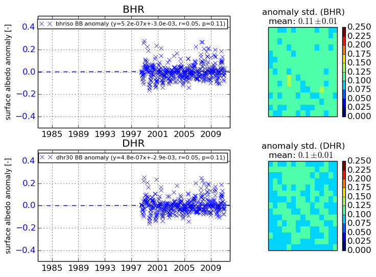
Temporal anomaly analyis

The variance of the temporal anomalies provides an additional measure about the stability of the signal AFTER removal of the mean seasonal cylce.

+000 deg


+057/+063 deg