BELMANIP_00335


Location

lon / lat [deg]: 88.1824 / 25.712

Source network: BELMANIP


Geostationary surface albedo (GSA) data


“+000”


“+057/+063”


Landcover information (based on ESA CCI landcover data)


Landcover fractions @ 2km distance


Landcover fractions @ 20 km distance


Legend


Distance to open water bodies [km]:

31.08

Distance to urban areas [km]:

5.93


Radius: 1 km

Number of landcover classes:

2

Dominant landcover type:

20: cropland, irrigated or post-flooded

Fraction of dominant landcover type [%]:

92.0


Radius: 2 km

Number of landcover classes:

2

Dominant landcover type:

20: cropland, irrigated or post-flooded

Fraction of dominant landcover type [%]:

88.0


Radius: 5 km

Number of landcover classes:

2

Dominant landcover type:

20: cropland, irrigated or post-flooded

Fraction of dominant landcover type [%]:

95.0


Radius: 10 km

Number of landcover classes:

2

Dominant landcover type:

20: cropland, irrigated or post-flooded

Fraction of dominant landcover type [%]:

96.0


Radius: 20 km

Number of landcover classes:

3

Dominant landcover type:

20: cropland, irrigated or post-flooded

Fraction of dominant landcover type [%]:

96.0


Disturbances


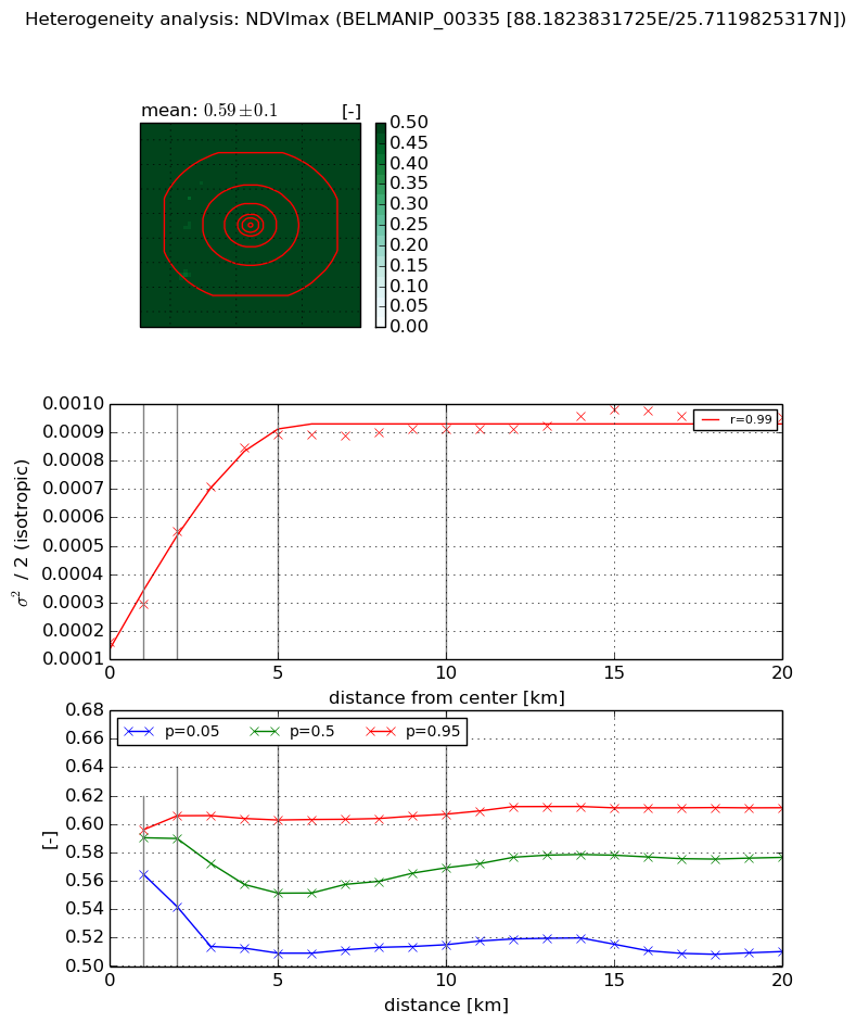
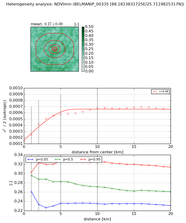
Heterogeneity analysis

The heterogeneity analysis provides information about the spatial and temporal heterogeneity of the site.

Topography


Roman et al. (2009) index


St

11.9188790587

Rcv

0.121988787494

Rse

0.0

Rst

-0.121597494137

Rsv

-0.00811524040173


Height range @ 1km [m]

6

Height range @ 2km [m]

6

Height range @ 5km [m]

8

Height range @ 10km [m]

-999

Height range @ 20km [m]

-999


Variance slope @ 1 km

2

Variance slope @ 2 km

1

Variance slope @ 5 km

0

Variance slope @ 10 km

-999

Variance slope @ 20 km

-999


NDVI (max. NDVI composite)


Roman et al. (2009) index


St

5.44226551541

Rcv

-0.0434277182153

Rse

0.0

Rst

0.284919805885

Rsv

-0.222893497034


NDVI range @ 1km [-]

0.03

NDVI range @ 2km [-]

0.06

NDVI range @ 5km [-]

0.09

NDVI range @ 10km [-]

0.09

NDVI range @ 20km [-]

0.1


Variance slope @ 1 km

0.000134072016002

Variance slope @ 2 km

0.000195667023069

Variance slope @ 5 km

0.000156143726715

Variance slope @ 10 km

6.96540286467e-05

Variance slope @ 20 km

2.60380996328e-05


NDVI (min. NDVI composite)I


Roman et al. (2009) index


St

8.91031867966

Rcv

-0.050987599952

Rse

0.0

Rst

-0.209054694996

Rsv

0.0766459995855


NDVI range @ 1km [-]

0.04

NDVI range @ 2km [-]

0.09

NDVI range @ 5km [-]

0.09

NDVI range @ 10km [-]

0.09

NDVI range @ 20km [-]

0.08


NDVI slope @ 1 km

0.000107840835439

NDVI slope @ 2 km

0.000139992245987

NDVI slope @ 5 km

9.18624925321e-05

NDVI slope @ 10 km

4.6366836591e-05

NDVI slope @ 20 km

1.85207382207e-05


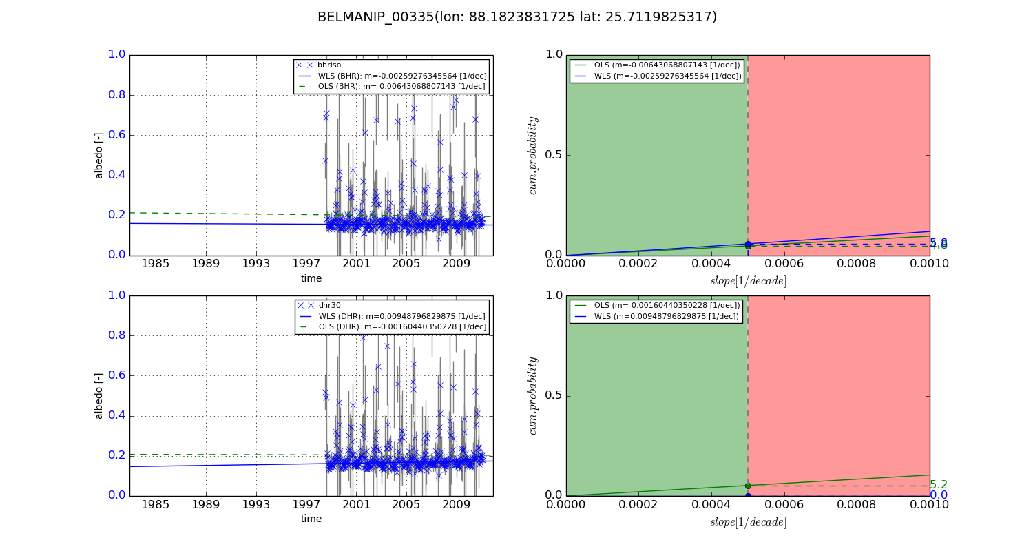
Temporal stability analysis

+000 deg (BHR)


BHR statistics

Temporal stability [1/decade]:


abs

rel


Weighted least square:

None


Ordinary least square:

None


Probabilities that GCOS criteria is met:

Weighted least square:

None %

Ordinary least square:

None %


DHR statistics

Temporal stability [1/decade]:


abs

rel


Weighted least square:

None


Ordinary least square:

None


Probabilities that GCOS criteria is met:

Weighted least square:

None %

Ordinary least square:

None %


+057/+063 deg (BHR)


BHR statistics

Temporal stability [1/decade]:


abs

rel


Weighted least square:

-0.00259276345564


Ordinary least square:

-0.00643068807143


Probabilities that GCOS criteria is met:

Weighted least square:

5.8 %

Ordinary least square:

4.8 %


DHR statistics

Temporal stability [1/decade]:


abs

rel


Weighted least square:

0.00948796829875


Ordinary least square:

-0.00160440350228


Probabilities that GCOS criteria is met:

Weighted least square:

0.0 %

Ordinary least square:

5.2 %


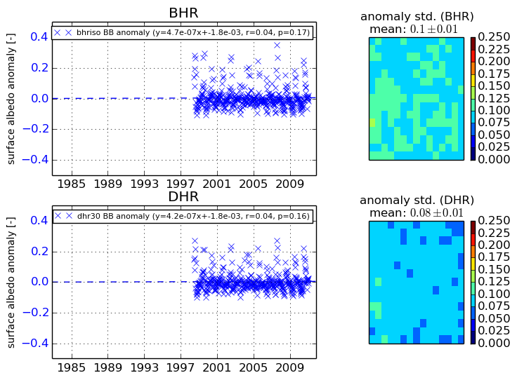
Temporal anomaly analyis

The variance of the temporal anomalies provides an additional measure about the stability of the signal AFTER removal of the mean seasonal cylce.

+000 deg


+057/+063 deg


By continuing to use this website, you are giving consent to analytic cookies being used. For more information on how EUMETSAT uses data and how you can disable this, please view this web page: Analytics Cookie Policy