BELMANIP_00350


Location

lon / lat [deg]: 107.9422 / 37.2879

Source network: BELMANIP


Geostationary surface albedo (GSA) data


“+000”


“+057/+063”


Landcover information (based on ESA CCI landcover data)


Landcover fractions @ 2km distance


Landcover fractions @ 20 km distance


Legend


Distance to open water bodies [km]:

21.52

Distance to urban areas [km]:

28.67


Radius: 1 km

Number of landcover classes:

3

Dominant landcover type:

130: grassland

Fraction of dominant landcover type [%]:

51.0


Radius: 2 km

Number of landcover classes:

3

Dominant landcover type:

130: grassland

Fraction of dominant landcover type [%]:

67.0


Radius: 5 km

Number of landcover classes:

4

Dominant landcover type:

130: grassland

Fraction of dominant landcover type [%]:

67.0


Radius: 10 km

Number of landcover classes:

3

Dominant landcover type:

130: grassland

Fraction of dominant landcover type [%]:

75.0


Radius: 20 km

Number of landcover classes:

4

Dominant landcover type:

130: grassland

Fraction of dominant landcover type [%]:

76.0


Disturbances


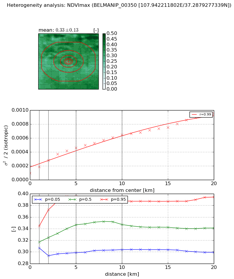
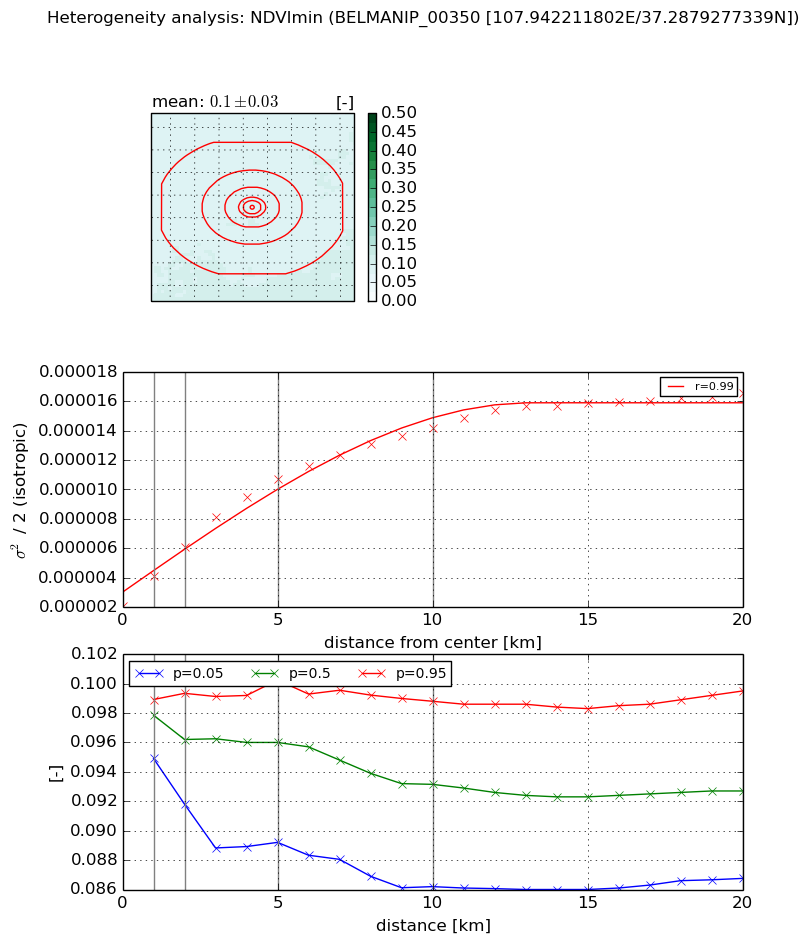
Heterogeneity analysis

The heterogeneity analysis provides information about the spatial and temporal heterogeneity of the site.

Topography


Roman et al. (2009) index


St

10.7705470857

Rcv

-0.0864300977738

Rse

0.0

Rst

0.0226461063677

Rsv

-0.169461178975


Height range @ 1km [m]

184

Height range @ 2km [m]

290

Height range @ 5km [m]

262

Height range @ 10km [m]

-999

Height range @ 20km [m]

-999


Variance slope @ 1 km

3591

Variance slope @ 2 km

2819

Variance slope @ 5 km

1314

Variance slope @ 10 km

-999

Variance slope @ 20 km

-999


NDVI (max. NDVI composite)


Roman et al. (2009) index


St

17.6449666343

Rcv

-0.0633168882135

Rse

0.0

Rst

-0.0374331535029

Rsv

-0.06927011543


NDVI range @ 1km [-]

0.04

NDVI range @ 2km [-]

0.08

NDVI range @ 5km [-]

0.1

NDVI range @ 10km [-]

0.08

NDVI range @ 20km [-]

0.1


Variance slope @ 1 km

9.14690525959e-05

Variance slope @ 2 km

9.33352497588e-05

Variance slope @ 5 km

7.42367415276e-05

Variance slope @ 10 km

5.16994909558e-05

Variance slope @ 20 km

3.77224284821e-05


NDVI (min. NDVI composite)I


Roman et al. (2009) index


St

5.01098849694e-07

Rcv

0.150527625218

Rse

0.0

Rst

0.000551906729359

Rsv

5986842.56835


NDVI range @ 1km [-]

0.0

NDVI range @ 2km [-]

0.01

NDVI range @ 5km [-]

0.01

NDVI range @ 10km [-]

0.01

NDVI range @ 20km [-]

0.01


NDVI slope @ 1 km

2.03402282378e-06

NDVI slope @ 2 km

2.00445133935e-06

NDVI slope @ 5 km

1.75530120128e-06

NDVI slope @ 10 km

1.18347959923e-06

NDVI slope @ 20 km

6.33087587964e-07


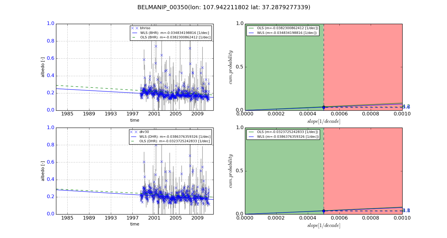
Temporal stability analysis

+000 deg (BHR)


BHR statistics

Temporal stability [1/decade]:


abs

rel


Weighted least square:

None


Ordinary least square:

None


Probabilities that GCOS criteria is met:

Weighted least square:

None %

Ordinary least square:

None %


DHR statistics

Temporal stability [1/decade]:


abs

rel


Weighted least square:

None


Ordinary least square:

None


Probabilities that GCOS criteria is met:

Weighted least square:

None %

Ordinary least square:

None %


+057/+063 deg (BHR)


BHR statistics

Temporal stability [1/decade]:


abs

rel


Weighted least square:

-0.034834198816


Ordinary least square:

-0.0382300862412


Probabilities that GCOS criteria is met:

Weighted least square:

3.6 %

Ordinary least square:

4.2 %


DHR statistics

Temporal stability [1/decade]:


abs

rel


Weighted least square:

-0.0386376359326


Ordinary least square:

-0.0323725242833


Probabilities that GCOS criteria is met:

Weighted least square:

3.8 %

Ordinary least square:

4.1 %


Temporal anomaly analyis

The variance of the temporal anomalies provides an additional measure about the stability of the signal AFTER removal of the mean seasonal cylce.

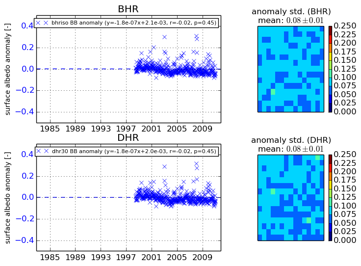
+000 deg


+057/+063 deg