BELMANIP_00361


Location

lon / lat [deg]: 92.4895 / 39.815

Source network: BELMANIP


Geostationary surface albedo (GSA) data


“+000”


“+057/+063”


Landcover information (based on ESA CCI landcover data)


Landcover fractions @ 2km distance


Landcover fractions @ 20 km distance


Legend


Distance to open water bodies [km]:

none in region

Distance to urban areas [km]:

none in region


Radius: 1 km

Number of landcover classes:

1

Dominant landcover type:

200: bare areas

Fraction of dominant landcover type [%]:

100.0


Radius: 2 km

Number of landcover classes:

2

Dominant landcover type:

200: bare areas

Fraction of dominant landcover type [%]:

98.0


Radius: 5 km

Number of landcover classes:

2

Dominant landcover type:

200: bare areas

Fraction of dominant landcover type [%]:

98.0


Radius: 10 km

Number of landcover classes:

2

Dominant landcover type:

200: bare areas

Fraction of dominant landcover type [%]:

89.0


Radius: 20 km

Number of landcover classes:

2

Dominant landcover type:

200: bare areas

Fraction of dominant landcover type [%]:

72.0


Disturbances


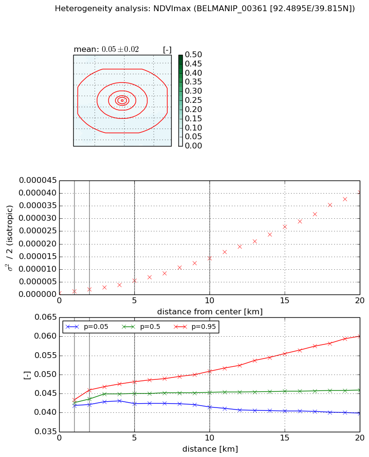
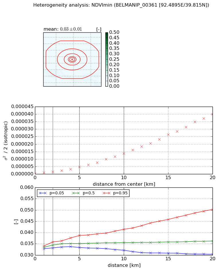
Heterogeneity analysis

The heterogeneity analysis provides information about the spatial and temporal heterogeneity of the site.

Topography


Roman et al. (2009) index


St

0.000113892860288

Rcv

0.0769916160171

Rse

0.0

Rst

-0.13768397923

Rsv

26340.3302227


Height range @ 1km [m]

202

Height range @ 2km [m]

171

Height range @ 5km [m]

176

Height range @ 10km [m]

-999

Height range @ 20km [m]

-999


Variance slope @ 1 km

1246

Variance slope @ 2 km

887

Variance slope @ 5 km

415

Variance slope @ 10 km

-999

Variance slope @ 20 km

-999


NDVI (max. NDVI composite)


Roman et al. (2009) index


St

1.6662952011

Rcv

0.347509941104

Rse

0.0

Rst

-0.452891679894

Rsv

-0.999999651245


NDVI range @ 1km [-]

0.0

NDVI range @ 2km [-]

0.0

NDVI range @ 5km [-]

0.01

NDVI range @ 10km [-]

0.01

NDVI range @ 20km [-]

0.02


Variance slope @ 1 km

7.026236615e-07

Variance slope @ 2 km

6.99319382845e-07

Variance slope @ 5 km

9.29372985669e-07

Variance slope @ 10 km

1.38431342147e-06

Variance slope @ 20 km

2.04682400694e-06


NDVI (min. NDVI composite)I


Roman et al. (2009) index


St

1.42160069103

Rcv

0.622508841163

Rse

0.0

Rst

-0.487788540349

Rsv

-0.99999984817


NDVI range @ 1km [-]

0.0

NDVI range @ 2km [-]

0.0

NDVI range @ 5km [-]

0.01

NDVI range @ 10km [-]

0.01

NDVI range @ 20km [-]

0.02


NDVI slope @ 1 km

5.12497212291e-07

NDVI slope @ 2 km

5.58013378162e-07

NDVI slope @ 5 km

8.55538608456e-07

NDVI slope @ 10 km

1.34766186039e-06

NDVI slope @ 20 km

2.04827036442e-06


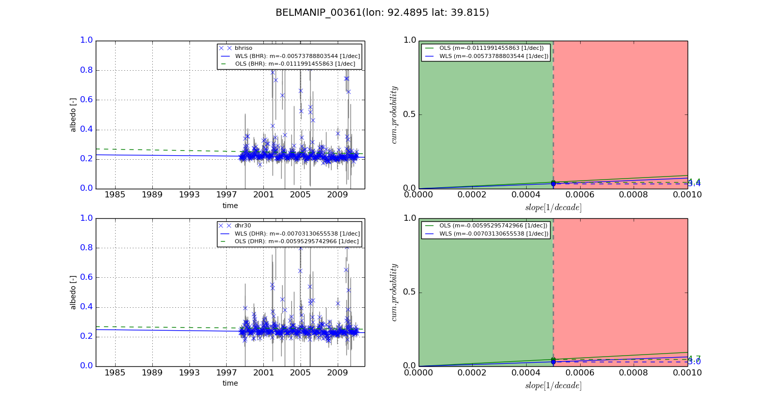
Temporal stability analysis

+000 deg (BHR)


BHR statistics

Temporal stability [1/decade]:


abs

rel


Weighted least square:

None


Ordinary least square:

None


Probabilities that GCOS criteria is met:

Weighted least square:

None %

Ordinary least square:

None %


DHR statistics

Temporal stability [1/decade]:


abs

rel


Weighted least square:

None


Ordinary least square:

None


Probabilities that GCOS criteria is met:

Weighted least square:

None %

Ordinary least square:

None %


+057/+063 deg (BHR)


BHR statistics

Temporal stability [1/decade]:


abs

rel


Weighted least square:

-0.00573788803544


Ordinary least square:

-0.0111991455863


Probabilities that GCOS criteria is met:

Weighted least square:

3.4 %

Ordinary least square:

4.4 %


DHR statistics

Temporal stability [1/decade]:


abs

rel


Weighted least square:

-0.00703130655538


Ordinary least square:

-0.00595295742966


Probabilities that GCOS criteria is met:

Weighted least square:

3.0 %

Ordinary least square:

4.7 %


Temporal anomaly analyis

The variance of the temporal anomalies provides an additional measure about the stability of the signal AFTER removal of the mean seasonal cylce.

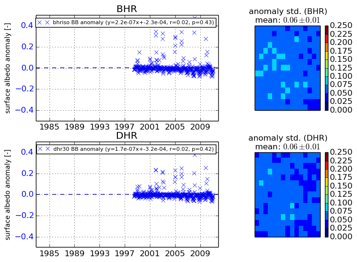
+000 deg


+057/+063 deg


By continuing to use this website, you are giving consent to analytic cookies being used. For more information on how EUMETSAT uses data and how you can disable this, please view this web page: Analytics Cookie Policy