BELMANIP_00370


Location

lon / lat [deg]: 106.3292 / 47.2209

Source network: BELMANIP


Geostationary surface albedo (GSA) data


“+000”


“+057/+063”


Landcover information (based on ESA CCI landcover data)


Landcover fractions @ 2km distance


Landcover fractions @ 20 km distance


Legend


Distance to open water bodies [km]:

46.5

Distance to urban areas [km]:

52.05


Radius: 1 km

Number of landcover classes:

1

Dominant landcover type:

130: grassland

Fraction of dominant landcover type [%]:

100.0


Radius: 2 km

Number of landcover classes:

1

Dominant landcover type:

130: grassland

Fraction of dominant landcover type [%]:

100.0


Radius: 5 km

Number of landcover classes:

1

Dominant landcover type:

130: grassland

Fraction of dominant landcover type [%]:

100.0


Radius: 10 km

Number of landcover classes:

1

Dominant landcover type:

130: grassland

Fraction of dominant landcover type [%]:

100.0


Radius: 20 km

Number of landcover classes:

1

Dominant landcover type:

130: grassland

Fraction of dominant landcover type [%]:

100.0


Disturbances


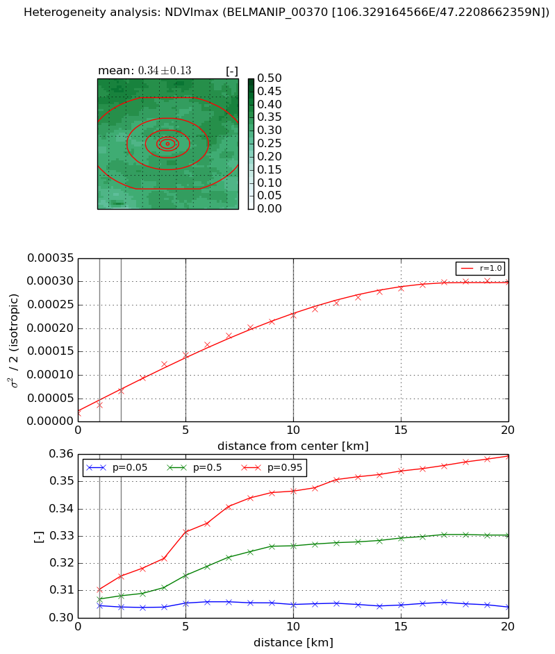
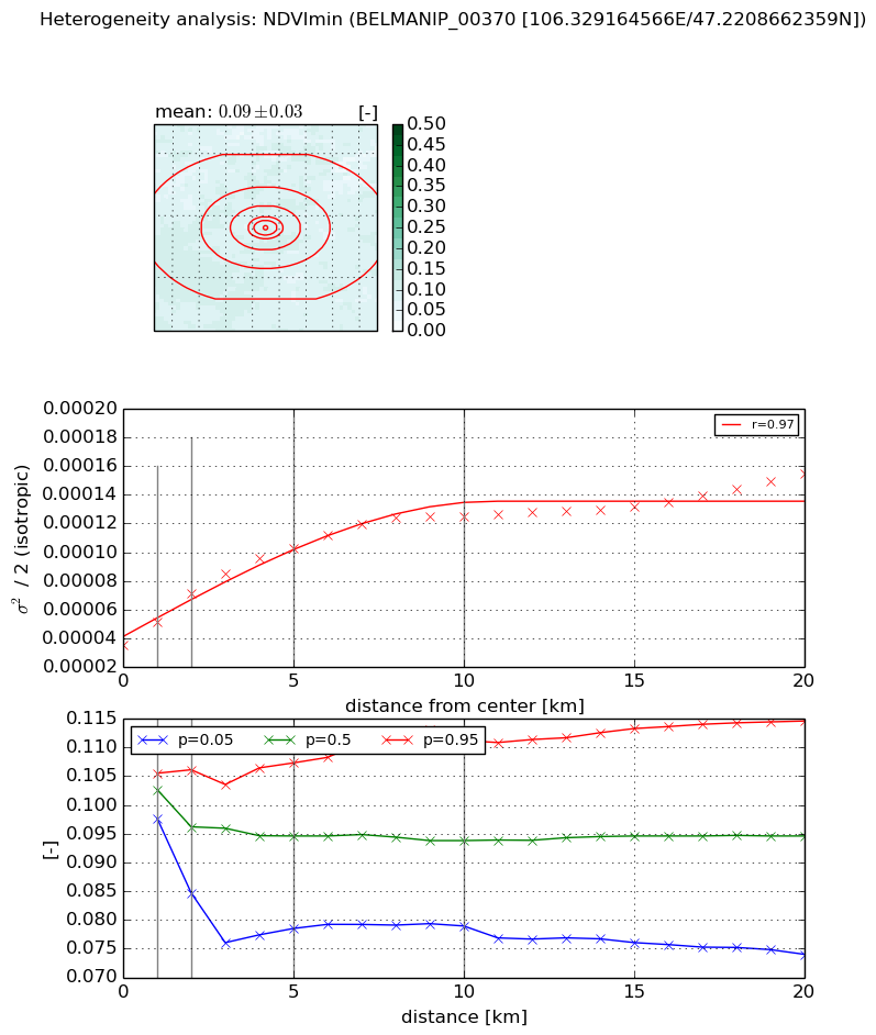
Heterogeneity analysis

The heterogeneity analysis provides information about the spatial and temporal heterogeneity of the site.

Topography


Roman et al. (2009) index


St

1.23628216197

Rcv

0.310539992835

Rse

0.0

Rst

1.36335436636e-06

Rsv

2.11608914312


Height range @ 1km [m]

51

Height range @ 2km [m]

75

Height range @ 5km [m]

134

Height range @ 10km [m]

-999

Height range @ 20km [m]

-999


Variance slope @ 1 km

218

Variance slope @ 2 km

294

Variance slope @ 5 km

376

Variance slope @ 10 km

-999

Variance slope @ 20 km

-999


NDVI (max. NDVI composite)


Roman et al. (2009) index


St

2.21454175605

Rcv

0.850377166183

Rse

0.0

Rst

-0.036268662648

Rsv

0.468036236569


NDVI range @ 1km [-]

0.01

NDVI range @ 2km [-]

0.01

NDVI range @ 5km [-]

0.03

NDVI range @ 10km [-]

0.04

NDVI range @ 20km [-]

0.06


Variance slope @ 1 km

1.81426032242e-05

Variance slope @ 2 km

2.43305622629e-05

Variance slope @ 5 km

2.62739206282e-05

Variance slope @ 10 km

2.18157560995e-05

Variance slope @ 20 km

1.43799592151e-05


NDVI (min. NDVI composite)I


Roman et al. (2009) index


St

2.25440784175e-07

Rcv

0.0205457993542

Rse

0.0

Rst

-0.0197851005996

Rsv

13307263.8204


NDVI range @ 1km [-]

0.01

NDVI range @ 2km [-]

0.02

NDVI range @ 5km [-]

0.03

NDVI range @ 10km [-]

0.03

NDVI range @ 20km [-]

0.04


NDVI slope @ 1 km

1.6476701257e-05

NDVI slope @ 2 km

1.81141917354e-05

NDVI slope @ 5 km

1.38679728783e-05

NDVI slope @ 10 km

8.9784143739e-06

NDVI slope @ 20 km

4.57377447931e-06


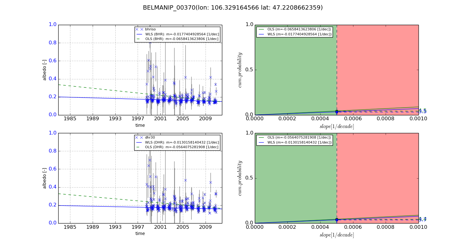
Temporal stability analysis

+000 deg (BHR)


BHR statistics

Temporal stability [1/decade]:


abs

rel


Weighted least square:

None


Ordinary least square:

None


Probabilities that GCOS criteria is met:

Weighted least square:

None %

Ordinary least square:

None %


DHR statistics

Temporal stability [1/decade]:


abs

rel


Weighted least square:

None


Ordinary least square:

None


Probabilities that GCOS criteria is met:

Weighted least square:

None %

Ordinary least square:

None %


+057/+063 deg (BHR)


BHR statistics

Temporal stability [1/decade]:


abs

rel


Weighted least square:

-0.0177404928564


Ordinary least square:

-0.0658413623806


Probabilities that GCOS criteria is met:

Weighted least square:

3.5 %

Ordinary least square:

4.5 %


DHR statistics

Temporal stability [1/decade]:


abs

rel


Weighted least square:

-0.0130158140432


Ordinary least square:

-0.0564075281908


Probabilities that GCOS criteria is met:

Weighted least square:

3.7 %

Ordinary least square:

4.4 %


Temporal anomaly analyis

The variance of the temporal anomalies provides an additional measure about the stability of the signal AFTER removal of the mean seasonal cylce.

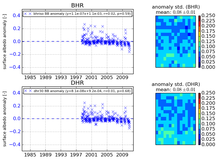
+000 deg


+057/+063 deg