BELMANIP_00393


Location

lon / lat [deg]: 132.9444 / 51.3865

Source network: BELMANIP


Geostationary surface albedo (GSA) data


“+000”


“+057/+063”


Landcover information (based on ESA CCI landcover data)


Landcover fractions @ 2km distance


Landcover fractions @ 20 km distance


Legend


Distance to open water bodies [km]:

9.52

Distance to urban areas [km]:

10.89


Radius: 1 km

Number of landcover classes:

2

Dominant landcover type:

80: Tree cover, needleleaved, deciduous, closed to open (>15%)

Fraction of dominant landcover type [%]:

92.0


Radius: 2 km

Number of landcover classes:

2

Dominant landcover type:

80: Tree cover, needleleaved, deciduous, closed to open (>15%)

Fraction of dominant landcover type [%]:

90.0


Radius: 5 km

Number of landcover classes:

2

Dominant landcover type:

80: Tree cover, needleleaved, deciduous, closed to open (>15%)

Fraction of dominant landcover type [%]:

93.0


Radius: 10 km

Number of landcover classes:

3

Dominant landcover type:

80: Tree cover, needleleaved, deciduous, closed to open (>15%)

Fraction of dominant landcover type [%]:

92.0


Radius: 20 km

Number of landcover classes:

6

Dominant landcover type:

80: Tree cover, needleleaved, deciduous, closed to open (>15%)

Fraction of dominant landcover type [%]:

85.0


Disturbances


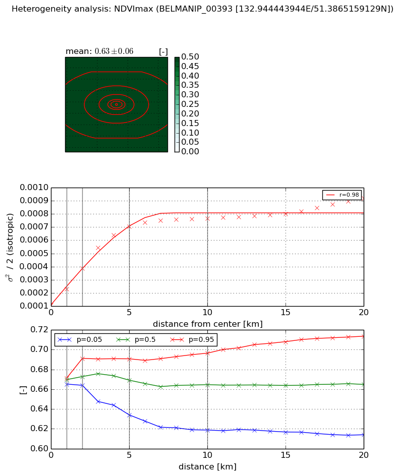
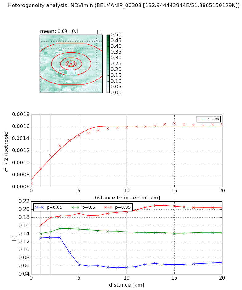
Heterogeneity analysis

The heterogeneity analysis provides information about the spatial and temporal heterogeneity of the site.

Topography


Roman et al. (2009) index


St

4.13594504492

Rcv

0.237792366358

Rse

0.0

Rst

-0.0578607653064

Rsv

0.429694997341


Height range @ 1km [m]

76

Height range @ 2km [m]

81

Height range @ 5km [m]

107

Height range @ 10km [m]

-999

Height range @ 20km [m]

-999


Variance slope @ 1 km

647

Variance slope @ 2 km

536

Variance slope @ 5 km

211

Variance slope @ 10 km

-999

Variance slope @ 20 km

-999


NDVI (max. NDVI composite)


Roman et al. (2009) index


St

1.5046619888e-05

Rcv

0.423763761081

Rse

0.0

Rst

-0.311229265624

Rsv

199379.592438


NDVI range @ 1km [-]

0.01

NDVI range @ 2km [-]

0.03

NDVI range @ 5km [-]

0.06

NDVI range @ 10km [-]

0.08

NDVI range @ 20km [-]

0.1


Variance slope @ 1 km

0.000120358398242

Variance slope @ 2 km

0.000138468988611

Variance slope @ 5 km

0.000124765294141

Variance slope @ 10 km

6.38740438365e-05

Variance slope @ 20 km

2.85677633862e-05


NDVI (min. NDVI composite)I


Roman et al. (2009) index


St

nan

Rcv

nan

Rse

nan

Rst

nan

Rsv

nan


NDVI range @ 1km [-]

0.03

NDVI range @ 2km [-]

0.05

NDVI range @ 5km [-]

0.13

NDVI range @ 10km [-]

0.14

NDVI range @ 20km [-]

0.14


NDVI slope @ 1 km

0.000245774325585

NDVI slope @ 2 km

0.000232331676784

NDVI slope @ 5 km

0.000156441436711

NDVI slope @ 10 km

8.50819849704e-05

NDVI slope @ 20 km

3.41269529404e-05


Temporal stability analysis

+000 deg (BHR)


BHR statistics

Temporal stability [1/decade]:


abs

rel


Weighted least square:

None


Ordinary least square:

None


Probabilities that GCOS criteria is met:

Weighted least square:

None %

Ordinary least square:

None %


DHR statistics

Temporal stability [1/decade]:


abs

rel


Weighted least square:

None


Ordinary least square:

None


Probabilities that GCOS criteria is met:

Weighted least square:

None %

Ordinary least square:

None %


+057/+063 deg (BHR)


BHR statistics

Temporal stability [1/decade]:


abs

rel


Weighted least square:

-99999.0


Ordinary least square:

-99999.0


Probabilities that GCOS criteria is met:

Weighted least square:

-99999.0 %

Ordinary least square:

-99999.0 %


DHR statistics

Temporal stability [1/decade]:


abs

rel


Weighted least square:

-99999.0


Ordinary least square:

-99999.0


Probabilities that GCOS criteria is met:

Weighted least square:

-99999.0 %

Ordinary least square:

-99999.0 %


Temporal anomaly analyis

The variance of the temporal anomalies provides an additional measure about the stability of the signal AFTER removal of the mean seasonal cylce.

+000 deg


+057/+063 deg