BELMANIP_00395


Location

lon / lat [deg]: 87.6783 / 52.0068

Source network: BELMANIP


Geostationary surface albedo (GSA) data


“+000”


“+057/+063”


Landcover information (based on ESA CCI landcover data)


Landcover fractions @ 2km distance


Landcover fractions @ 20 km distance


Legend


Distance to open water bodies [km]:

21.04

Distance to urban areas [km]:

none in region


Radius: 1 km

Number of landcover classes:

2

Dominant landcover type:

90: Tree cover, mixed leaf type

Fraction of dominant landcover type [%]:

87.0


Radius: 2 km

Number of landcover classes:

3

Dominant landcover type:

90: Tree cover, mixed leaf type

Fraction of dominant landcover type [%]:

79.0


Radius: 5 km

Number of landcover classes:

3

Dominant landcover type:

90: Tree cover, mixed leaf type

Fraction of dominant landcover type [%]:

74.0


Radius: 10 km

Number of landcover classes:

3

Dominant landcover type:

90: Tree cover, mixed leaf type

Fraction of dominant landcover type [%]:

72.0


Radius: 20 km

Number of landcover classes:

3

Dominant landcover type:

90: Tree cover, mixed leaf type

Fraction of dominant landcover type [%]:

62.0


Disturbances


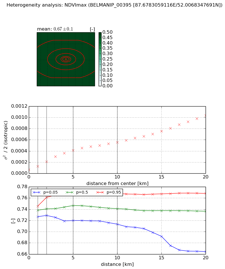
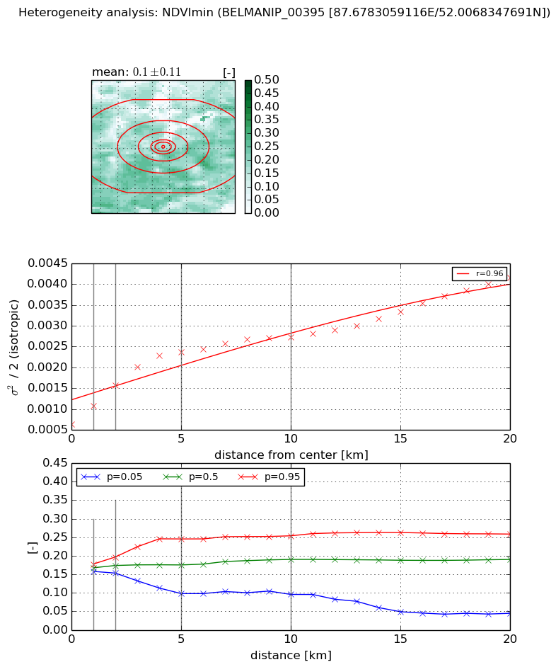
Heterogeneity analysis

The heterogeneity analysis provides information about the spatial and temporal heterogeneity of the site.

Topography


Roman et al. (2009) index


St

8.93476515247e-05

Rcv

-0.04451744689

Rse

0.0

Rst

-0.0399140146451

Rsv

33576.6235044


Height range @ 1km [m]

167

Height range @ 2km [m]

235

Height range @ 5km [m]

351

Height range @ 10km [m]

-999

Height range @ 20km [m]

-999


Variance slope @ 1 km

4909

Variance slope @ 2 km

4381

Variance slope @ 5 km

2074

Variance slope @ 10 km

-999

Variance slope @ 20 km

-999


NDVI (max. NDVI composite)


Roman et al. (2009) index


St

2.57235563456

Rcv

0.312031073565

Rse

0.0

Rst

0.00785581986572

Rsv

0.846359312847


NDVI range @ 1km [-]

0.02

NDVI range @ 2km [-]

0.03

NDVI range @ 5km [-]

0.05

NDVI range @ 10km [-]

0.06

NDVI range @ 20km [-]

0.1


Variance slope @ 1 km

6.06946400804e-05

Variance slope @ 2 km

7.12125223731e-05

Variance slope @ 5 km

7.20946198802e-05

Variance slope @ 10 km

4.88553086416e-05

Variance slope @ 20 km

4.31923796325e-05


NDVI (min. NDVI composite)I


Roman et al. (2009) index


St

2.06946915649

Rcv

0.477357620815

Rse

0.0

Rst

-0.0699479913566

Rsv

0.902341506553


NDVI range @ 1km [-]

0.02

NDVI range @ 2km [-]

0.04

NDVI range @ 5km [-]

0.15

NDVI range @ 10km [-]

0.16

NDVI range @ 20km [-]

0.21


NDVI slope @ 1 km

0.000445311737627

NDVI slope @ 2 km

0.000468867809062

NDVI slope @ 5 km

0.000365533822928

NDVI slope @ 10 km

0.00019621879445

NDVI slope @ 20 km

0.000141100542678


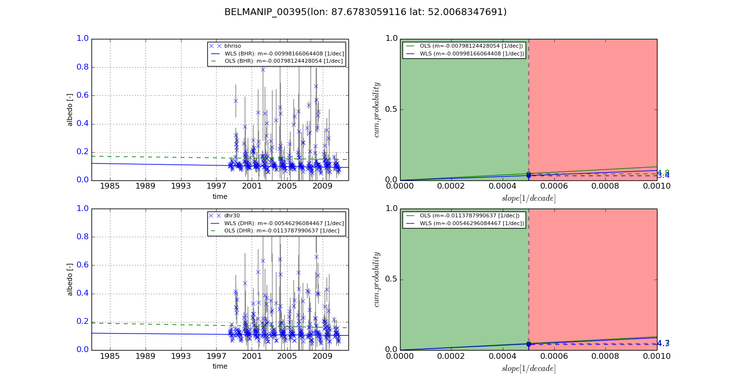
Temporal stability analysis

+000 deg (BHR)


BHR statistics

Temporal stability [1/decade]:


abs

rel


Weighted least square:

None


Ordinary least square:

None


Probabilities that GCOS criteria is met:

Weighted least square:

None %

Ordinary least square:

None %


DHR statistics

Temporal stability [1/decade]:


abs

rel


Weighted least square:

None


Ordinary least square:

None


Probabilities that GCOS criteria is met:

Weighted least square:

None %

Ordinary least square:

None %


+057/+063 deg (BHR)


BHR statistics

Temporal stability [1/decade]:


abs

rel


Weighted least square:

-0.00998166064408


Ordinary least square:

-0.00798124428054


Probabilities that GCOS criteria is met:

Weighted least square:

3.4 %

Ordinary least square:

4.8 %


DHR statistics

Temporal stability [1/decade]:


abs

rel


Weighted least square:

-0.00546296084467


Ordinary least square:

-0.0113787990637


Probabilities that GCOS criteria is met:

Weighted least square:

4.3 %

Ordinary least square:

4.7 %


Temporal anomaly analyis

The variance of the temporal anomalies provides an additional measure about the stability of the signal AFTER removal of the mean seasonal cylce.

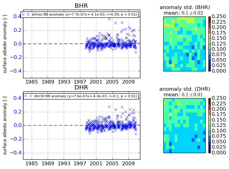
+000 deg


+057/+063 deg