BELMANIP_00423


Location

lon / lat [deg]: 82.5223 / 36.6741

Source network: BELMANIP


Geostationary surface albedo (GSA) data


“+000”


“+057/+063”


Landcover information (based on ESA CCI landcover data)


Landcover fractions @ 2km distance


Landcover fractions @ 20 km distance


Legend


Distance to open water bodies [km]:

29.19

Distance to urban areas [km]:

45.81


Radius: 1 km

Number of landcover classes:

1

Dominant landcover type:

200: bare areas

Fraction of dominant landcover type [%]:

100.0


Radius: 2 km

Number of landcover classes:

1

Dominant landcover type:

200: bare areas

Fraction of dominant landcover type [%]:

100.0


Radius: 5 km

Number of landcover classes:

1

Dominant landcover type:

200: bare areas

Fraction of dominant landcover type [%]:

100.0


Radius: 10 km

Number of landcover classes:

2

Dominant landcover type:

200: bare areas

Fraction of dominant landcover type [%]:

94.0


Radius: 20 km

Number of landcover classes:

3

Dominant landcover type:

200: bare areas

Fraction of dominant landcover type [%]:

77.0


Disturbances


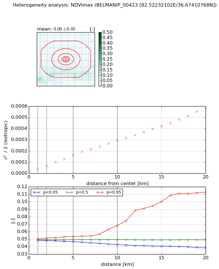
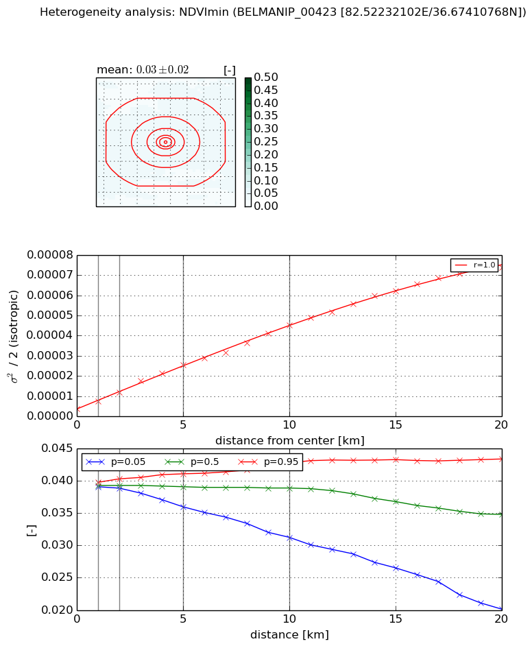
Heterogeneity analysis

The heterogeneity analysis provides information about the spatial and temporal heterogeneity of the site.

Topography


Roman et al. (2009) index


St

0.892131409752

Rcv

0.662184393569

Rse

0.0

Rst

4.98513180828e-05

Rsv

2.70049905562


Height range @ 1km [m]

77

Height range @ 2km [m]

156

Height range @ 5km [m]

388

Height range @ 10km [m]

-999

Height range @ 20km [m]

-999


Variance slope @ 1 km

582

Variance slope @ 2 km

1174

Variance slope @ 5 km

2900

Variance slope @ 10 km

-999

Variance slope @ 20 km

-999


NDVI (max. NDVI composite)


Roman et al. (2009) index


St

3.51291725145

Rcv

0.503052485246

Rse

0.0

Rst

-0.348364480606

Rsv

0.00257411485344


NDVI range @ 1km [-]

0.0

NDVI range @ 2km [-]

0.0

NDVI range @ 5km [-]

0.01

NDVI range @ 10km [-]

0.03

NDVI range @ 20km [-]

0.07


Variance slope @ 1 km

2.06152183565e-05

Variance slope @ 2 km

2.43733475214e-05

Variance slope @ 5 km

2.90130969379e-05

Variance slope @ 10 km

2.81920028836e-05

Variance slope @ 20 km

2.75288747566e-05


NDVI (min. NDVI composite)I


Roman et al. (2009) index


St

1.25270845843

Rcv

1.04974585407

Rse

0.0

Rst

-0.345065842955

Rsv

-0.999999306143


NDVI range @ 1km [-]

0.0

NDVI range @ 2km [-]

0.0

NDVI range @ 5km [-]

0.01

NDVI range @ 10km [-]

0.01

NDVI range @ 20km [-]

0.02


NDVI slope @ 1 km

3.54934945073e-06

NDVI slope @ 2 km

4.13370469271e-06

NDVI slope @ 5 km

4.48376688868e-06

NDVI slope @ 10 km

4.09468667154e-06

NDVI slope @ 20 km

3.6415579842e-06


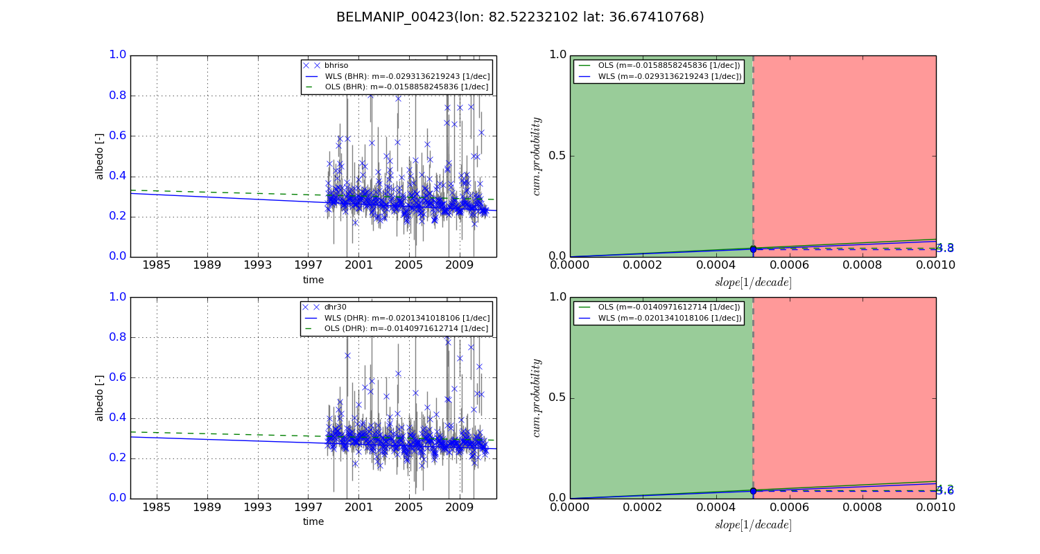
Temporal stability analysis

+000 deg (BHR)


BHR statistics

Temporal stability [1/decade]:


abs

rel


Weighted least square:

None


Ordinary least square:

None


Probabilities that GCOS criteria is met:

Weighted least square:

None %

Ordinary least square:

None %


DHR statistics

Temporal stability [1/decade]:


abs

rel


Weighted least square:

None


Ordinary least square:

None


Probabilities that GCOS criteria is met:

Weighted least square:

None %

Ordinary least square:

None %


+057/+063 deg (BHR)


BHR statistics

Temporal stability [1/decade]:


abs

rel


Weighted least square:

-0.0293136219243


Ordinary least square:

-0.0158858245836


Probabilities that GCOS criteria is met:

Weighted least square:

3.8 %

Ordinary least square:

4.3 %


DHR statistics

Temporal stability [1/decade]:


abs

rel


Weighted least square:

-0.0201341018106


Ordinary least square:

-0.0140971612714


Probabilities that GCOS criteria is met:

Weighted least square:

3.6 %

Ordinary least square:

4.2 %


Temporal anomaly analyis

The variance of the temporal anomalies provides an additional measure about the stability of the signal AFTER removal of the mean seasonal cylce.

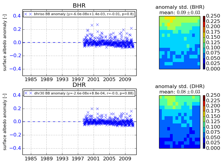
+000 deg


+057/+063 deg