BELMANIP_00430


Location

lon / lat [deg]: 89.567 / 38.692

Source network: BELMANIP


Geostationary surface albedo (GSA) data


“+000”


“+057/+063”


Landcover information (based on ESA CCI landcover data)


Landcover fractions @ 2km distance


Landcover fractions @ 20 km distance


Legend


Distance to open water bodies [km]:

12.26

Distance to urban areas [km]:

none in region


Radius: 1 km

Number of landcover classes:

1

Dominant landcover type:

200: bare areas

Fraction of dominant landcover type [%]:

100.0


Radius: 2 km

Number of landcover classes:

1

Dominant landcover type:

200: bare areas

Fraction of dominant landcover type [%]:

100.0


Radius: 5 km

Number of landcover classes:

2

Dominant landcover type:

200: bare areas

Fraction of dominant landcover type [%]:

96.0


Radius: 10 km

Number of landcover classes:

2

Dominant landcover type:

200: bare areas

Fraction of dominant landcover type [%]:

95.0


Radius: 20 km

Number of landcover classes:

3

Dominant landcover type:

200: bare areas

Fraction of dominant landcover type [%]:

90.0


Disturbances


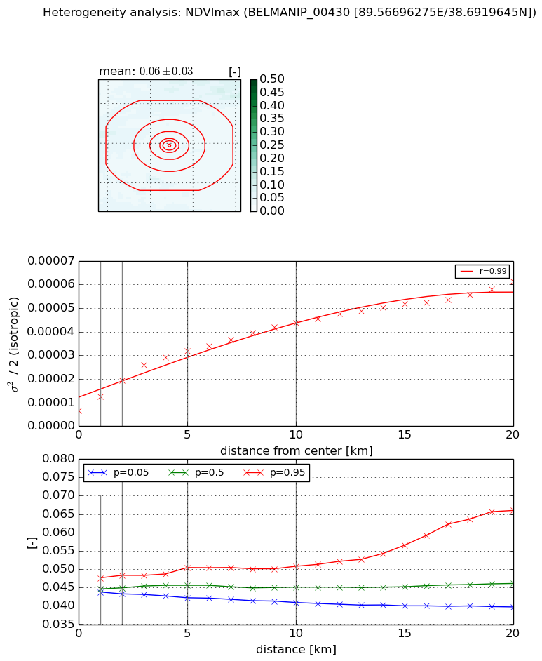
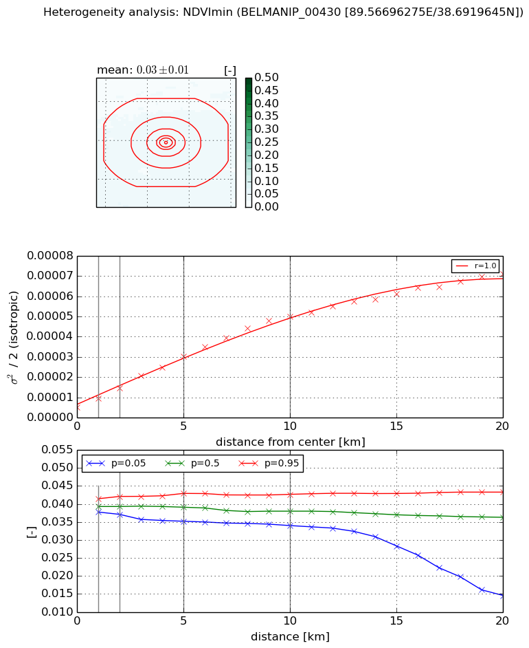
Heterogeneity analysis

The heterogeneity analysis provides information about the spatial and temporal heterogeneity of the site.

Topography


Roman et al. (2009) index


St

1.81780600486

Rcv

0.677808781761

Rse

0.0

Rst

-4.4408920985e-16

Rsv

-0.972532339333


Height range @ 1km [m]

49

Height range @ 2km [m]

105

Height range @ 5km [m]

274

Height range @ 10km [m]

-999

Height range @ 20km [m]

-999


Variance slope @ 1 km

591

Variance slope @ 2 km

818

Variance slope @ 5 km

1550

Variance slope @ 10 km

-999

Variance slope @ 20 km

-999


NDVI (max. NDVI composite)


Roman et al. (2009) index


St

2.35500474428

Rcv

0.438623893793

Rse

0.0

Rst

-0.106358081039

Rsv

0.728900809177


NDVI range @ 1km [-]

0.0

NDVI range @ 2km [-]

0.01

NDVI range @ 5km [-]

0.01

NDVI range @ 10km [-]

0.01

NDVI range @ 20km [-]

0.03


Variance slope @ 1 km

6.01624431228e-06

Variance slope @ 2 km

6.43575552068e-06

Variance slope @ 5 km

5.21400337404e-06

Variance slope @ 10 km

3.55253631493e-06

Variance slope @ 20 km

2.33701252956e-06


NDVI (min. NDVI composite)I


Roman et al. (2009) index


St

1.10330859104e-07

Rcv

0.28998974804

Rse

0.0

Rst

0.180536015782

Rsv

27190941.6138


NDVI range @ 1km [-]

0.0

NDVI range @ 2km [-]

0.0

NDVI range @ 5km [-]

0.01

NDVI range @ 10km [-]

0.01

NDVI range @ 20km [-]

0.03


NDVI slope @ 1 km

4.2255546937e-06

NDVI slope @ 2 km

4.72493253694e-06

NDVI slope @ 5 km

5.07284380894e-06

NDVI slope @ 10 km

4.66792427625e-06

NDVI slope @ 20 km

3.23863992573e-06


Temporal stability analysis

+000 deg (BHR)


BHR statistics

Temporal stability [1/decade]:


abs

rel


Weighted least square:

None


Ordinary least square:

None


Probabilities that GCOS criteria is met:

Weighted least square:

None %

Ordinary least square:

None %


DHR statistics

Temporal stability [1/decade]:


abs

rel


Weighted least square:

None


Ordinary least square:

None


Probabilities that GCOS criteria is met:

Weighted least square:

None %

Ordinary least square:

None %


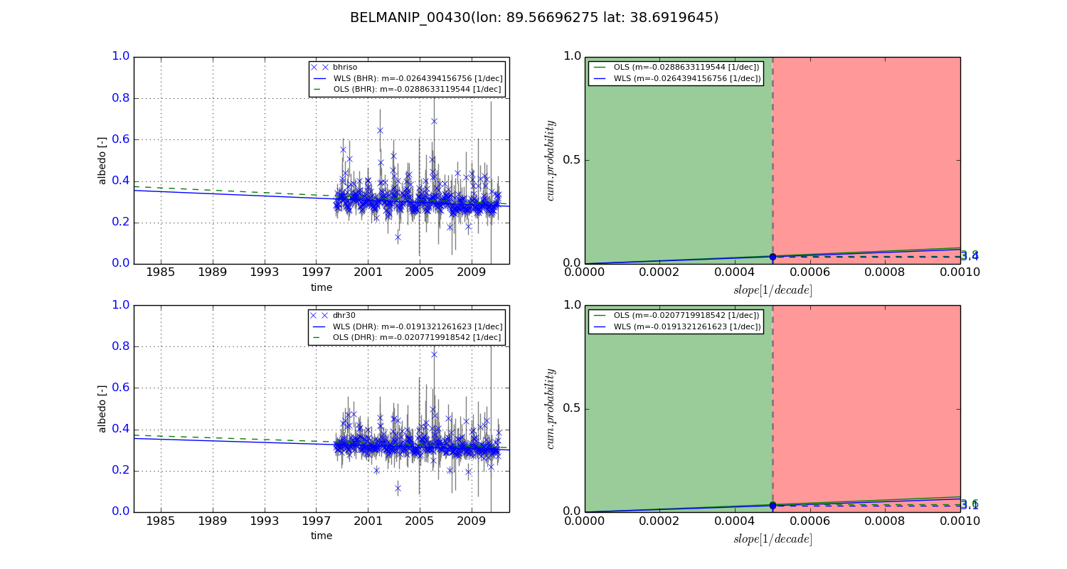
+057/+063 deg (BHR)


BHR statistics

Temporal stability [1/decade]:


abs

rel


Weighted least square:

-0.0264394156756


Ordinary least square:

-0.0288633119544


Probabilities that GCOS criteria is met:

Weighted least square:

3.4 %

Ordinary least square:

3.8 %


DHR statistics

Temporal stability [1/decade]:


abs

rel


Weighted least square:

-0.0191321261623


Ordinary least square:

-0.0207719918542


Probabilities that GCOS criteria is met:

Weighted least square:

3.1 %

Ordinary least square:

3.6 %


Temporal anomaly analyis

The variance of the temporal anomalies provides an additional measure about the stability of the signal AFTER removal of the mean seasonal cylce.

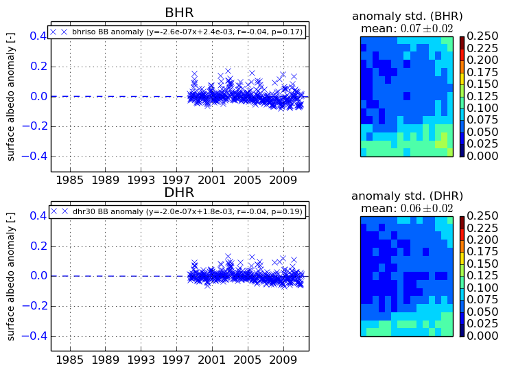
+000 deg


+057/+063 deg