BELSK


Location

lon / lat [deg]: 20.7917 / 51.8367

Source network: AERONET


Geostationary surface albedo (GSA) data


“+000”


“+057/+063”


Landcover information (based on ESA CCI landcover data)


Landcover fractions @ 2km distance


Landcover fractions @ 20 km distance


Legend


Distance to open water bodies [km]:

9.04

Distance to urban areas [km]:

1.43


Radius: 1 km

Number of landcover classes:

5

Dominant landcover type:

10: cropland, rainfed

Fraction of dominant landcover type [%]:

37.0


Radius: 2 km

Number of landcover classes:

6

Dominant landcover type:

12: cropland, tree or shrub cover

Fraction of dominant landcover type [%]:

43.0


Radius: 5 km

Number of landcover classes:

6

Dominant landcover type:

12: cropland, tree or shrub cover

Fraction of dominant landcover type [%]:

67.0


Radius: 10 km

Number of landcover classes:

8

Dominant landcover type:

12: cropland, tree or shrub cover

Fraction of dominant landcover type [%]:

57.0


Radius: 20 km

Number of landcover classes:

9

Dominant landcover type:

10: cropland, rainfed

Fraction of dominant landcover type [%]:

44.0


Disturbances


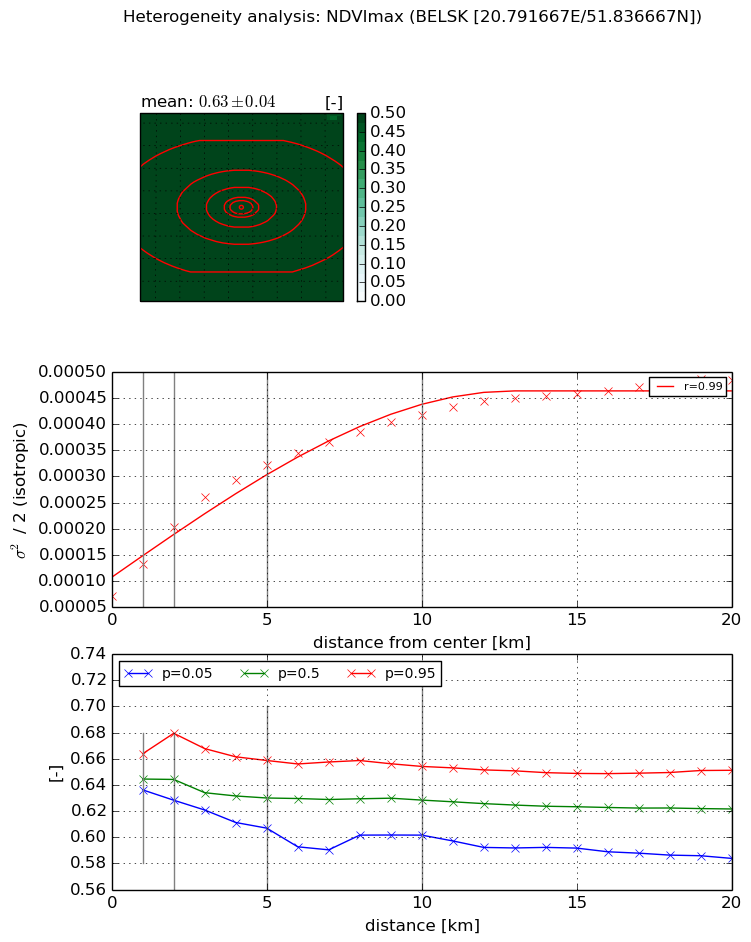
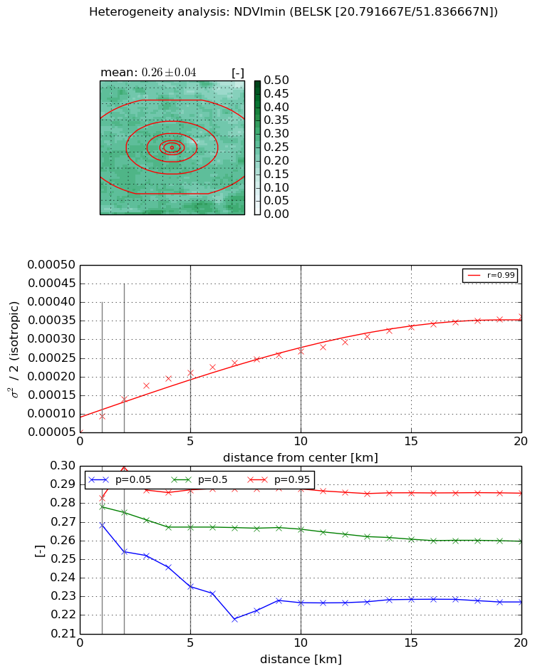
Heterogeneity analysis

The heterogeneity analysis provides information about the spatial and temporal heterogeneity of the site.

Topography


Roman et al. (2009) index


St

2.32570051078

Rcv

0.15653765832

Rse

0.0

Rst

-0.0832878114822

Rsv

1.05010846025


Height range @ 1km [m]

26

Height range @ 2km [m]

38

Height range @ 5km [m]

38

Height range @ 10km [m]

-999

Height range @ 20km [m]

-999


Variance slope @ 1 km

39

Variance slope @ 2 km

35

Variance slope @ 5 km

30

Variance slope @ 10 km

-999

Variance slope @ 20 km

-999


NDVI (max. NDVI composite)


Roman et al. (2009) index


St

2.34336032983

Rcv

0.0796068258195

Rse

0.0

Rst

-0.46296713636

Rsv

0.737638885074


NDVI range @ 1km [-]

0.03

NDVI range @ 2km [-]

0.05

NDVI range @ 5km [-]

0.05

NDVI range @ 10km [-]

0.05

NDVI range @ 20km [-]

0.07


Variance slope @ 1 km

6.26208229201e-05

Variance slope @ 2 km

6.62476613412e-05

Variance slope @ 5 km

5.1189939079e-05

Variance slope @ 10 km

3.29391704188e-05

Variance slope @ 20 km

1.76152064564e-05


NDVI (min. NDVI composite)I


Roman et al. (2009) index


St

1.55057491888

Rcv

0.339288242923

Rse

0.0

Rst

-0.595478277068

Rsv

-0.999999716369


NDVI range @ 1km [-]

0.01

NDVI range @ 2km [-]

0.05

NDVI range @ 5km [-]

0.05

NDVI range @ 10km [-]

0.06

NDVI range @ 20km [-]

0.06


NDVI slope @ 1 km

4.30335101715e-05

NDVI slope @ 2 km

4.40607918217e-05

NDVI slope @ 5 km

3.25378084645e-05

NDVI slope @ 10 km

2.01479381873e-05

NDVI slope @ 20 km

1.37215299509e-05


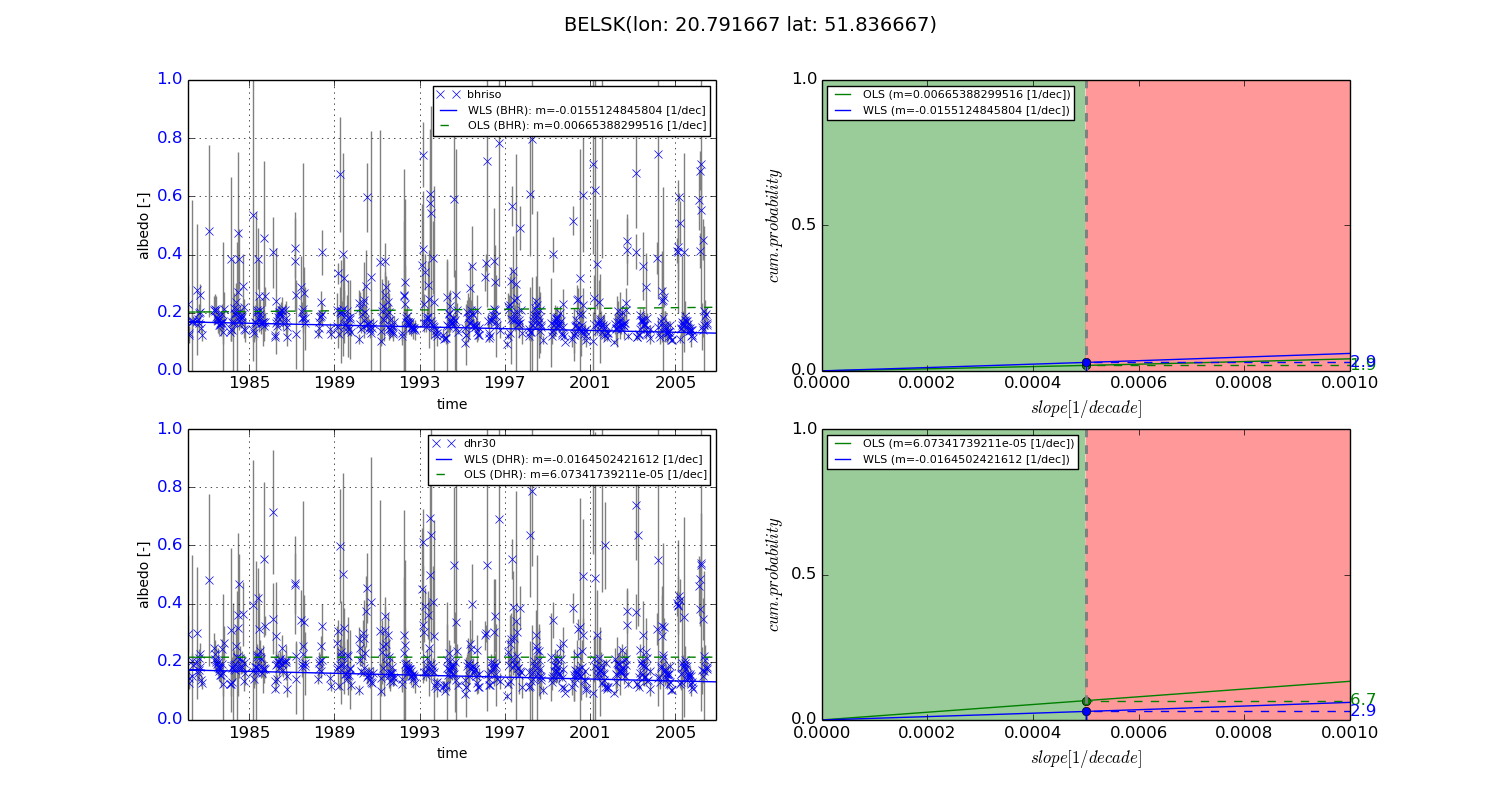
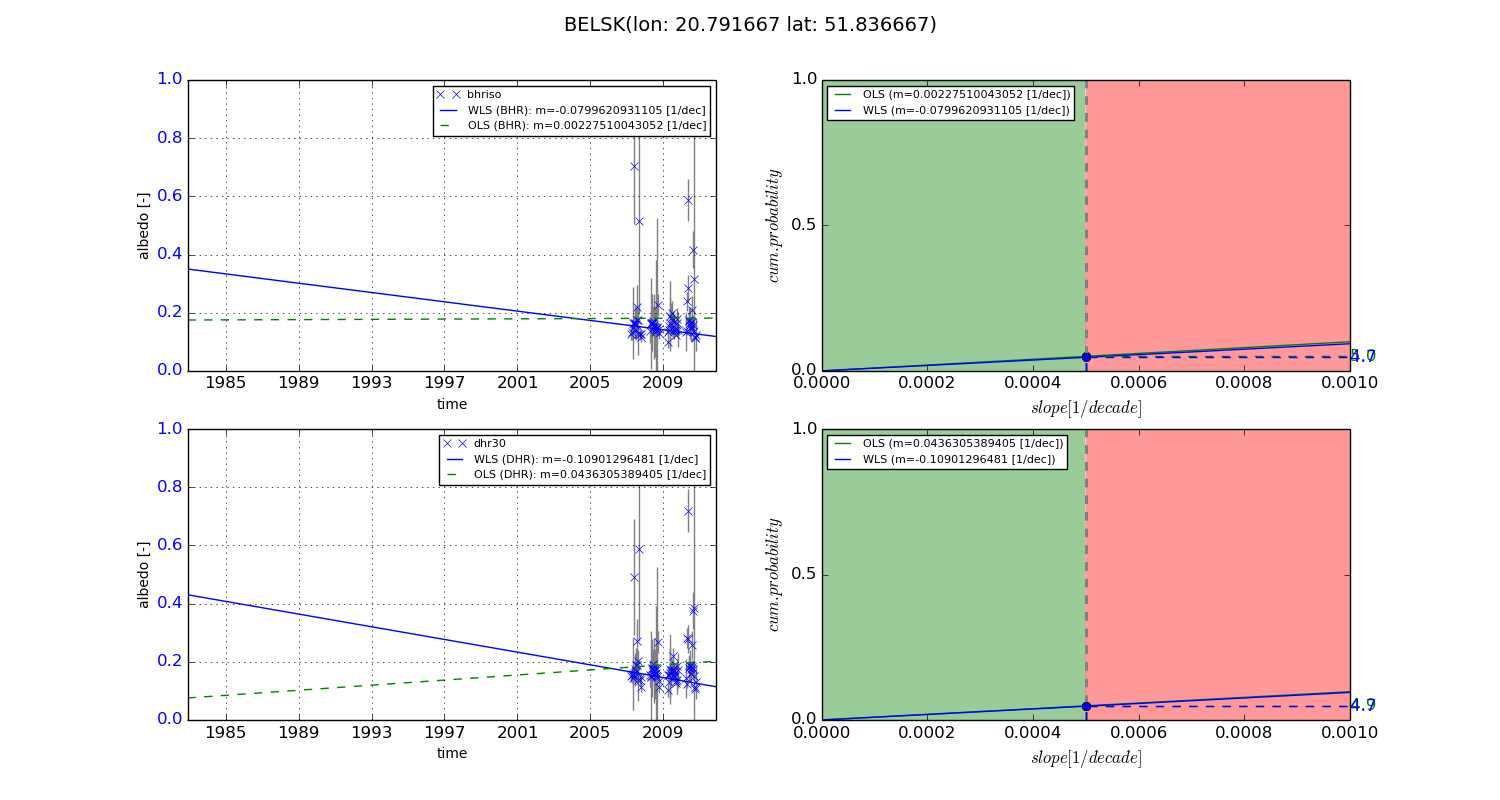
Temporal stability analysis

+000 deg (BHR)


BHR statistics

Temporal stability [1/decade]:


abs

rel


Weighted least square:

-0.0155124845804


Ordinary least square:

0.00665388299516


Probabilities that GCOS criteria is met:

Weighted least square:

2.9 %

Ordinary least square:

1.9 %


DHR statistics

Temporal stability [1/decade]:


abs

rel


Weighted least square:

-0.0164502421612


Ordinary least square:

6.07341739211e-05


Probabilities that GCOS criteria is met:

Weighted least square:

2.9 %

Ordinary least square:

6.7 %


+057/+063 deg (BHR)


BHR statistics

Temporal stability [1/decade]:


abs

rel


Weighted least square:

-0.0799620931105


Ordinary least square:

0.00227510043052


Probabilities that GCOS criteria is met:

Weighted least square:

4.7 %

Ordinary least square:

5.0 %


DHR statistics

Temporal stability [1/decade]:


abs

rel


Weighted least square:

-0.10901296481


Ordinary least square:

0.0436305389405


Probabilities that GCOS criteria is met:

Weighted least square:

4.7 %

Ordinary least square:

4.9 %


Temporal anomaly analyis

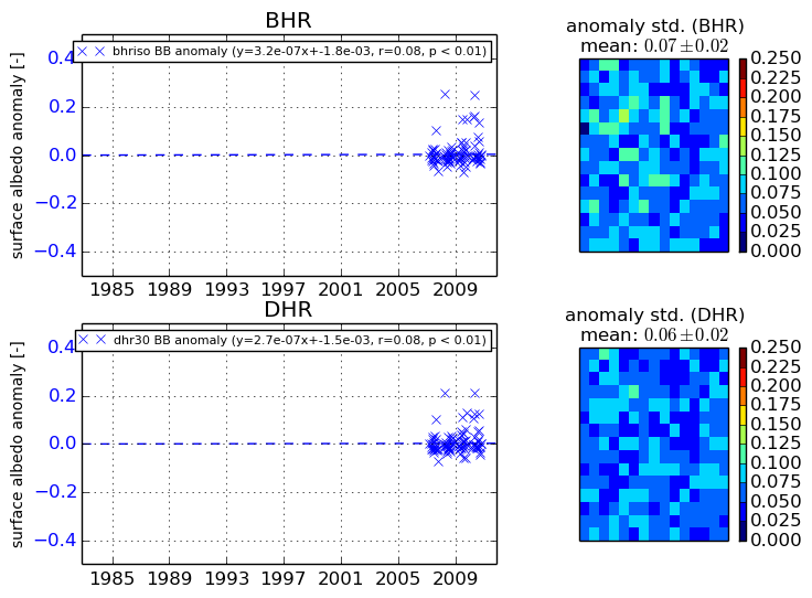
The variance of the temporal anomalies provides an additional measure about the stability of the signal AFTER removal of the mean seasonal cylce.
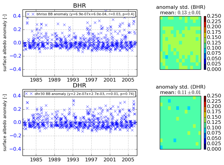
+000 deg


+057/+063 deg