BERMS_BOREAS


Location

lon / lat [deg]: -105.32 / 53.65

Source network: EOS_LAND


Geostationary surface albedo (GSA) data


“+000”


“+057/+063”


Landcover information (based on ESA CCI landcover data)


Landcover fractions @ 2km distance


Landcover fractions @ 20 km distance


Legend


Distance to open water bodies [km]:

6.26

Distance to urban areas [km]:

45.44


Radius: 1 km

Number of landcover classes:

5

Dominant landcover type:

61: Tree cover, broadleaved, decidous (closed > 40%)

Fraction of dominant landcover type [%]:

46.0


Radius: 2 km

Number of landcover classes:

7

Dominant landcover type:

70: Tree cover, needleleaved, evergreen, closed to open (>15%)

Fraction of dominant landcover type [%]:

38.0


Radius: 5 km

Number of landcover classes:

6

Dominant landcover type:

70: Tree cover, needleleaved, evergreen, closed to open (>15%)

Fraction of dominant landcover type [%]:

78.0


Radius: 10 km

Number of landcover classes:

9

Dominant landcover type:

70: Tree cover, needleleaved, evergreen, closed to open (>15%)

Fraction of dominant landcover type [%]:

76.0


Radius: 20 km

Number of landcover classes:

10

Dominant landcover type:

70: Tree cover, needleleaved, evergreen, closed to open (>15%)

Fraction of dominant landcover type [%]:

56.0


Disturbances


Heterogeneity analysis

The heterogeneity analysis provides information about the spatial and temporal heterogeneity of the site.

Topography


Roman et al. (2009) index


St

5.00411595019

Rcv

0.498057493984

Rse

0.0

Rst

-1.55767835041e-06

Rsv

-0.101447440565


Height range @ 1km [m]

18

Height range @ 2km [m]

29

Height range @ 5km [m]

60

Height range @ 10km [m]

-999

Height range @ 20km [m]

-999


Variance slope @ 1 km

28

Variance slope @ 2 km

39

Variance slope @ 5 km

76

Variance slope @ 10 km

-999

Variance slope @ 20 km

-999


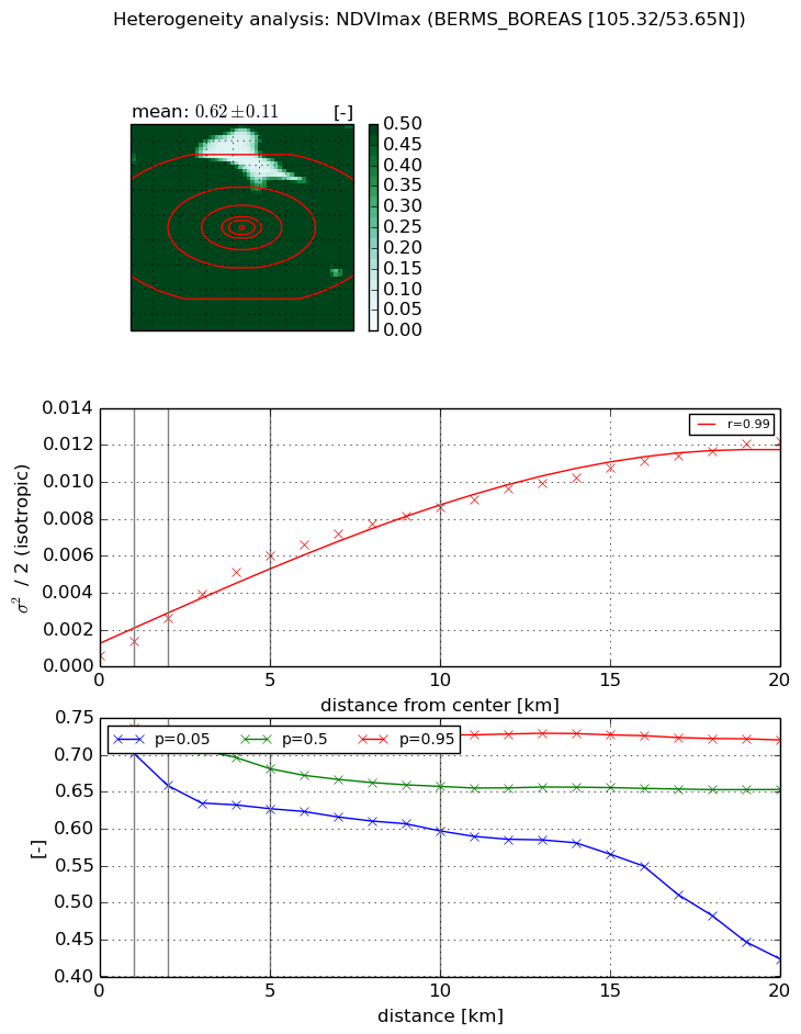
NDVI (max. NDVI composite)


Roman et al. (2009) index


St

0.00371434639824

Rcv

0.175373939919

Rse

0.0

Rst

4.28552388885e-06

Rsv

807.503733615


NDVI range @ 1km [-]

0.03

NDVI range @ 2km [-]

0.07

NDVI range @ 5km [-]

0.1

NDVI range @ 10km [-]

0.13

NDVI range @ 20km [-]

0.3


Variance slope @ 1 km

0.000793026634589

Variance slope @ 2 km

0.00101186886664

Variance slope @ 5 km

0.00113042853748

Variance slope @ 10 km

0.000825104255174

Variance slope @ 20 km

0.000550542897946


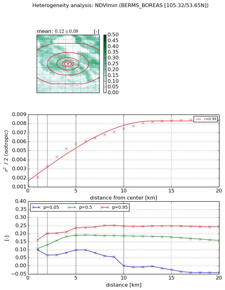
NDVI (min. NDVI composite)I


Roman et al. (2009) index


St

8.12902069245

Rcv

-0.210315433357

Rse

0.0

Rst

-0.0452280701914

Rsv

0.113504640564


NDVI range @ 1km [-]

0.06

NDVI range @ 2km [-]

0.13

NDVI range @ 5km [-]

0.14

NDVI range @ 10km [-]

0.25

NDVI range @ 20km [-]

0.28


NDVI slope @ 1 km

0.000935642210835

NDVI slope @ 2 km

0.00105379463996

NDVI slope @ 5 km

0.000961369208509

NDVI slope @ 10 km

0.000609266161917

NDVI slope @ 20 km

0.000324024305544


Temporal stability analysis

+000 deg (BHR)


BHR statistics

Temporal stability [1/decade]:


abs

rel


Weighted least square:

None


Ordinary least square:

None


Probabilities that GCOS criteria is met:

Weighted least square:

None %

Ordinary least square:

None %


DHR statistics

Temporal stability [1/decade]:


abs

rel


Weighted least square:

None


Ordinary least square:

None


Probabilities that GCOS criteria is met:

Weighted least square:

None %

Ordinary least square:

None %


+057/+063 deg (BHR)


BHR statistics

Temporal stability [1/decade]:


abs

rel


Weighted least square:

None


Ordinary least square:

None


Probabilities that GCOS criteria is met:

Weighted least square:

None %

Ordinary least square:

None %


DHR statistics

Temporal stability [1/decade]:


abs

rel


Weighted least square:

None


Ordinary least square:

None


Probabilities that GCOS criteria is met:

Weighted least square:

None %

Ordinary least square:

None %


Temporal anomaly analyis

The variance of the temporal anomalies provides an additional measure about the stability of the signal AFTER removal of the mean seasonal cylce.

+000 deg


+057/+063 deg