BOYD_COUNTY_MS


Location

lon / lat [deg]: -82.7 / 38.4275

Source network: AERONET


Geostationary surface albedo (GSA) data


“+000”


“+057/+063”


Landcover information (based on ESA CCI landcover data)


Landcover fractions @ 2km distance


Landcover fractions @ 20 km distance


Legend


Distance to open water bodies [km]:

2.07

Distance to urban areas [km]:

0.17


Radius: 1 km

Number of landcover classes:

3

Dominant landcover type:

190: urban areas

Fraction of dominant landcover type [%]:

62.0


Radius: 2 km

Number of landcover classes:

4

Dominant landcover type:

190: urban areas

Fraction of dominant landcover type [%]:

42.0


Radius: 5 km

Number of landcover classes:

5

Dominant landcover type:

130: grassland

Fraction of dominant landcover type [%]:

49.0


Radius: 10 km

Number of landcover classes:

5

Dominant landcover type:

130: grassland

Fraction of dominant landcover type [%]:

52.0


Radius: 20 km

Number of landcover classes:

5

Dominant landcover type:

130: grassland

Fraction of dominant landcover type [%]:

51.0


Disturbances


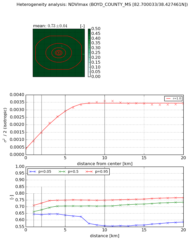
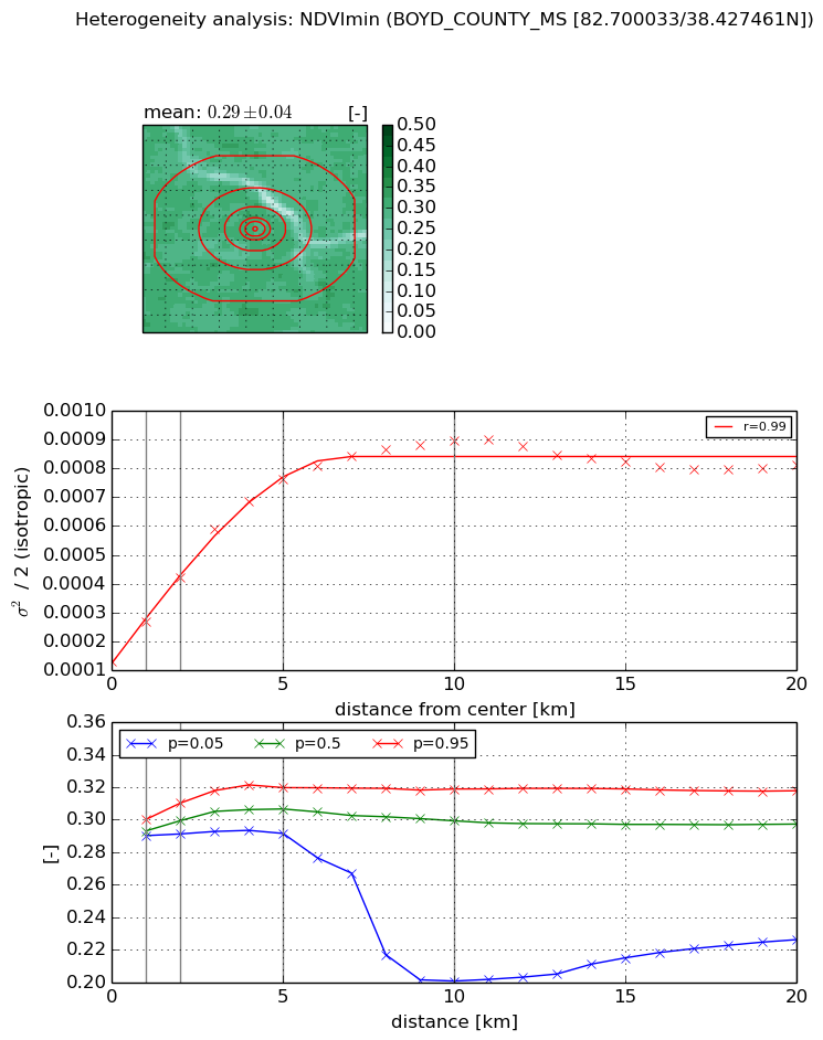
Heterogeneity analysis

The heterogeneity analysis provides information about the spatial and temporal heterogeneity of the site.

Topography


Roman et al. (2009) index


St

7.81665521625

Rcv

0.0497128350012

Rse

0.0

Rst

-0.160488665819

Rsv

0.17359437056


Height range @ 1km [m]

50

Height range @ 2km [m]

70

Height range @ 5km [m]

81

Height range @ 10km [m]

-999

Height range @ 20km [m]

-999


Variance slope @ 1 km

399

Variance slope @ 2 km

224

Variance slope @ 5 km

92

Variance slope @ 10 km

-999

Variance slope @ 20 km

-999


NDVI (max. NDVI composite)


Roman et al. (2009) index


St

5.52351902516

Rcv

0.113991437951

Rse

0.0

Rst

-0.0822763928949

Rsv

0.346864180891


NDVI range @ 1km [-]

0.07

NDVI range @ 2km [-]

0.09

NDVI range @ 5km [-]

0.11

NDVI range @ 10km [-]

0.19

NDVI range @ 20km [-]

0.18


Variance slope @ 1 km

0.00047544398917

Variance slope @ 2 km

0.000516580131898

Variance slope @ 5 km

0.000514912050951

Variance slope @ 10 km

0.000320916610788

Variance slope @ 20 km

0.000109604469016


NDVI (min. NDVI composite)I


Roman et al. (2009) index


St

nan

Rcv

nan

Rse

nan

Rst

nan

Rsv

nan


NDVI range @ 1km [-]

0.01

NDVI range @ 2km [-]

0.02

NDVI range @ 5km [-]

0.03

NDVI range @ 10km [-]

0.12

NDVI range @ 20km [-]

0.09


NDVI slope @ 1 km

0.000137670857621

NDVI slope @ 2 km

0.000146631819924

NDVI slope @ 5 km

0.000130730878044

NDVI slope @ 10 km

7.50913335384e-05

NDVI slope @ 20 km

2.23627241366e-05


Temporal stability analysis

+000 deg (BHR)


BHR statistics

Temporal stability [1/decade]:


abs

rel


Weighted least square:

None


Ordinary least square:

None


Probabilities that GCOS criteria is met:

Weighted least square:

None %

Ordinary least square:

None %


DHR statistics

Temporal stability [1/decade]:


abs

rel


Weighted least square:

None


Ordinary least square:

None


Probabilities that GCOS criteria is met:

Weighted least square:

None %

Ordinary least square:

None %


+057/+063 deg (BHR)


BHR statistics

Temporal stability [1/decade]:


abs

rel


Weighted least square:

None


Ordinary least square:

None


Probabilities that GCOS criteria is met:

Weighted least square:

None %

Ordinary least square:

None %


DHR statistics

Temporal stability [1/decade]:


abs

rel


Weighted least square:

None


Ordinary least square:

None


Probabilities that GCOS criteria is met:

Weighted least square:

None %

Ordinary least square:

None %


Temporal anomaly analyis

The variance of the temporal anomalies provides an additional measure about the stability of the signal AFTER removal of the mean seasonal cylce.

+000 deg


+057/+063 deg