BOZEMAN


Location

lon / lat [deg]: -111.045 / 45.6622

Source network: AERONET


Geostationary surface albedo (GSA) data


“+000”


“+057/+063”


Landcover information (based on ESA CCI landcover data)


Landcover fractions @ 2km distance


Landcover fractions @ 20 km distance


Legend


Distance to open water bodies [km]:

4.69

Distance to urban areas [km]:

0.07


Radius: 1 km

Number of landcover classes:

3

Dominant landcover type:

190: urban areas

Fraction of dominant landcover type [%]:

85.0


Radius: 2 km

Number of landcover classes:

4

Dominant landcover type:

190: urban areas

Fraction of dominant landcover type [%]:

61.0


Radius: 5 km

Number of landcover classes:

4

Dominant landcover type:

130: grassland

Fraction of dominant landcover type [%]:

49.0


Radius: 10 km

Number of landcover classes:

5

Dominant landcover type:

130: grassland

Fraction of dominant landcover type [%]:

53.0


Radius: 20 km

Number of landcover classes:

5

Dominant landcover type:

130: grassland

Fraction of dominant landcover type [%]:

42.0


Disturbances


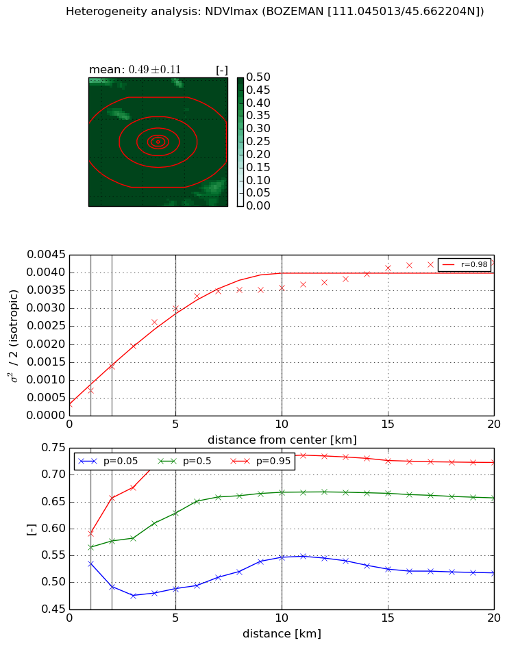
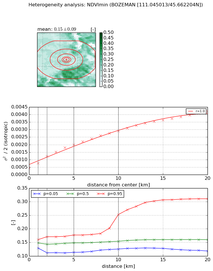
Heterogeneity analysis

The heterogeneity analysis provides information about the spatial and temporal heterogeneity of the site.

Topography


Roman et al. (2009) index


St

0.543407391599

Rcv

0.833178681424

Rse

0.0

Rst

1.10613324498e-06

Rsv

4.68754011132


Height range @ 1km [m]

21

Height range @ 2km [m]

52

Height range @ 5km [m]

145

Height range @ 10km [m]

-999

Height range @ 20km [m]

-999


Variance slope @ 1 km

373

Variance slope @ 2 km

446

Variance slope @ 5 km

432

Variance slope @ 10 km

-999

Variance slope @ 20 km

-999


NDVI (max. NDVI composite)


Roman et al. (2009) index


St

3.67233214776

Rcv

-0.000402055589613

Rse

0.0

Rst

0.130246281981

Rsv

0.68627123269


NDVI range @ 1km [-]

0.06

NDVI range @ 2km [-]

0.16

NDVI range @ 5km [-]

0.24

NDVI range @ 10km [-]

0.19

NDVI range @ 20km [-]

0.21


Variance slope @ 1 km

0.000390790604049

Variance slope @ 2 km

0.00053241031447

Variance slope @ 5 km

0.000565175532579

Variance slope @ 10 km

0.000342925604984

Variance slope @ 20 km

0.000169185775804


NDVI (min. NDVI composite)I


Roman et al. (2009) index


St

19.4708547972

Rcv

0.011278658931

Rse

0.0

Rst

-0.115405743927

Rsv

-0.0273920376092


NDVI range @ 1km [-]

0.03

NDVI range @ 2km [-]

0.06

NDVI range @ 5km [-]

0.06

NDVI range @ 10km [-]

0.13

NDVI range @ 20km [-]

0.19


NDVI slope @ 1 km

0.000312265345808

NDVI slope @ 2 km

0.000387669208409

NDVI slope @ 5 km

0.000317720410216

NDVI slope @ 10 km

0.000240933570627

NDVI slope @ 20 km

0.000176061195837


Temporal stability analysis

+000 deg (BHR)


BHR statistics

Temporal stability [1/decade]:


abs

rel


Weighted least square:

None


Ordinary least square:

None


Probabilities that GCOS criteria is met:

Weighted least square:

None %

Ordinary least square:

None %


DHR statistics

Temporal stability [1/decade]:


abs

rel


Weighted least square:

None


Ordinary least square:

None


Probabilities that GCOS criteria is met:

Weighted least square:

None %

Ordinary least square:

None %


+057/+063 deg (BHR)


BHR statistics

Temporal stability [1/decade]:


abs

rel


Weighted least square:

None


Ordinary least square:

None


Probabilities that GCOS criteria is met:

Weighted least square:

None %

Ordinary least square:

None %


DHR statistics

Temporal stability [1/decade]:


abs

rel


Weighted least square:

None


Ordinary least square:

None


Probabilities that GCOS criteria is met:

Weighted least square:

None %

Ordinary least square:

None %


Temporal anomaly analyis

The variance of the temporal anomalies provides an additional measure about the stability of the signal AFTER removal of the mean seasonal cylce.

+000 deg


+057/+063 deg