BW-GHM


Location

lon / lat [deg]: 21.75 / -21.2

Source network: FLUXNET


Geostationary surface albedo (GSA) data


“+000”


“+057/+063”


Landcover information (based on ESA CCI landcover data)


Landcover fractions @ 2km distance


Landcover fractions @ 20 km distance


Legend


Distance to open water bodies [km]:

40.29

Distance to urban areas [km]:

none in region


Radius: 1 km

Number of landcover classes:

1

Dominant landcover type:

130: grassland

Fraction of dominant landcover type [%]:

100.0


Radius: 2 km

Number of landcover classes:

1

Dominant landcover type:

130: grassland

Fraction of dominant landcover type [%]:

100.0


Radius: 5 km

Number of landcover classes:

1

Dominant landcover type:

130: grassland

Fraction of dominant landcover type [%]:

100.0


Radius: 10 km

Number of landcover classes:

1

Dominant landcover type:

130: grassland

Fraction of dominant landcover type [%]:

100.0


Radius: 20 km

Number of landcover classes:

1

Dominant landcover type:

130: grassland

Fraction of dominant landcover type [%]:

100.0


Disturbances


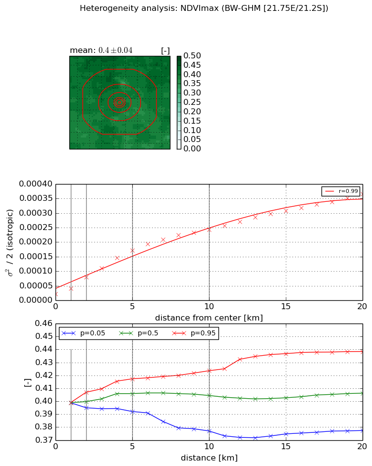
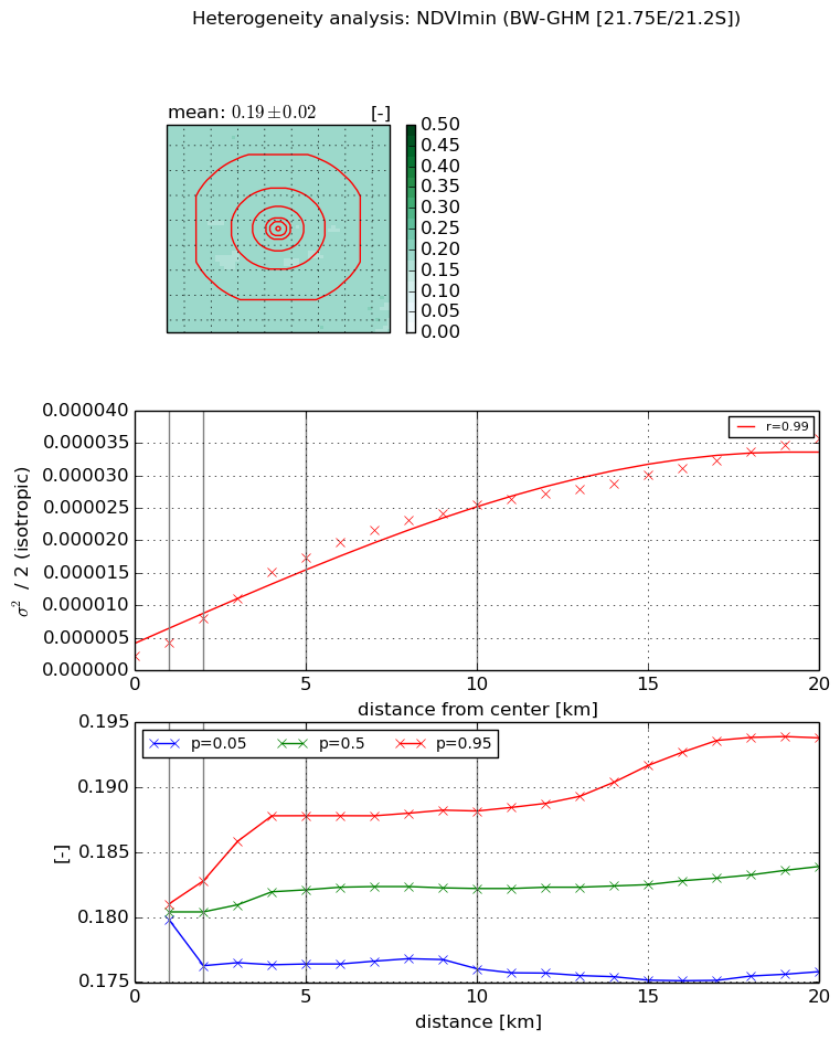
Heterogeneity analysis

The heterogeneity analysis provides information about the spatial and temporal heterogeneity of the site.

Topography


Roman et al. (2009) index


St

0.000375246823339

Rcv

0.54896793142

Rse

0.0

Rst

0.000107600511728

Rsv

7994.18882339


Height range @ 1km [m]

4

Height range @ 2km [m]

7

Height range @ 5km [m]

16

Height range @ 10km [m]

-999

Height range @ 20km [m]

-999


Variance slope @ 1 km

1

Variance slope @ 2 km

2

Variance slope @ 5 km

4

Variance slope @ 10 km

-999

Variance slope @ 20 km

-999


NDVI (max. NDVI composite)


Roman et al. (2009) index


St

nan

Rcv

nan

Rse

nan

Rst

nan

Rsv

nan


NDVI range @ 1km [-]

0.0

NDVI range @ 2km [-]

0.01

NDVI range @ 5km [-]

0.03

NDVI range @ 10km [-]

0.05

NDVI range @ 20km [-]

0.06


Variance slope @ 1 km

1.83209401111e-05

Variance slope @ 2 km

2.85259873365e-05

Variance slope @ 5 km

3.14011210675e-05

Variance slope @ 10 km

2.3268600926e-05

Variance slope @ 20 km

1.59913873249e-05


NDVI (min. NDVI composite)I


Roman et al. (2009) index


St

1.96307785637e-07

Rcv

0.226305732734

Rse

0.0

Rst

0.192343534012

Rsv

15282123.9773


NDVI range @ 1km [-]

0.0

NDVI range @ 2km [-]

0.01

NDVI range @ 5km [-]

0.01

NDVI range @ 10km [-]

0.01

NDVI range @ 20km [-]

0.02


NDVI slope @ 1 km

1.99292910491e-06

NDVI slope @ 2 km

2.85501484291e-06

NDVI slope @ 5 km

3.17422523164e-06

NDVI slope @ 10 km

2.4248329472e-06

NDVI slope @ 20 km

1.54235062064e-06


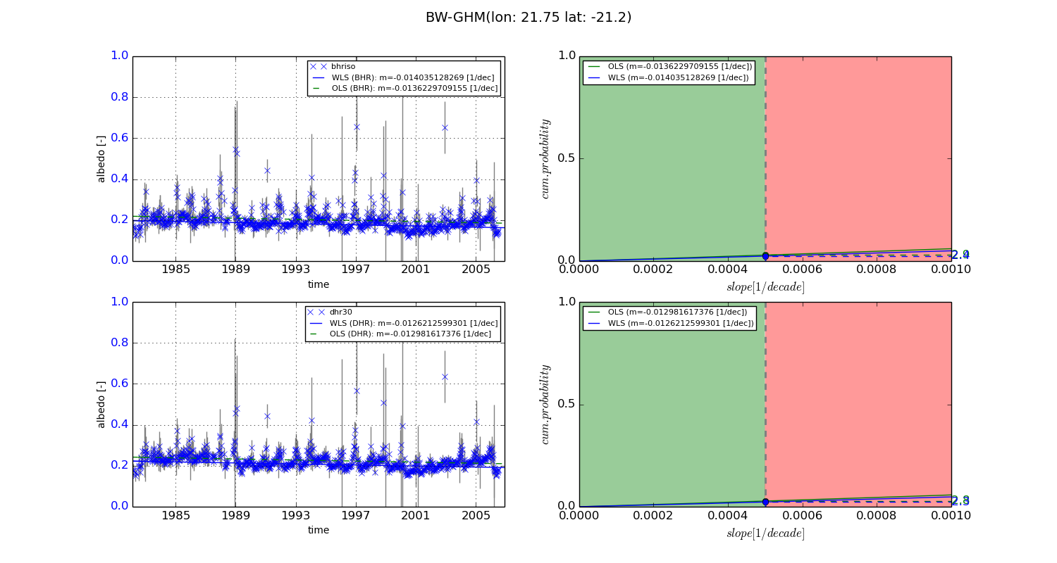
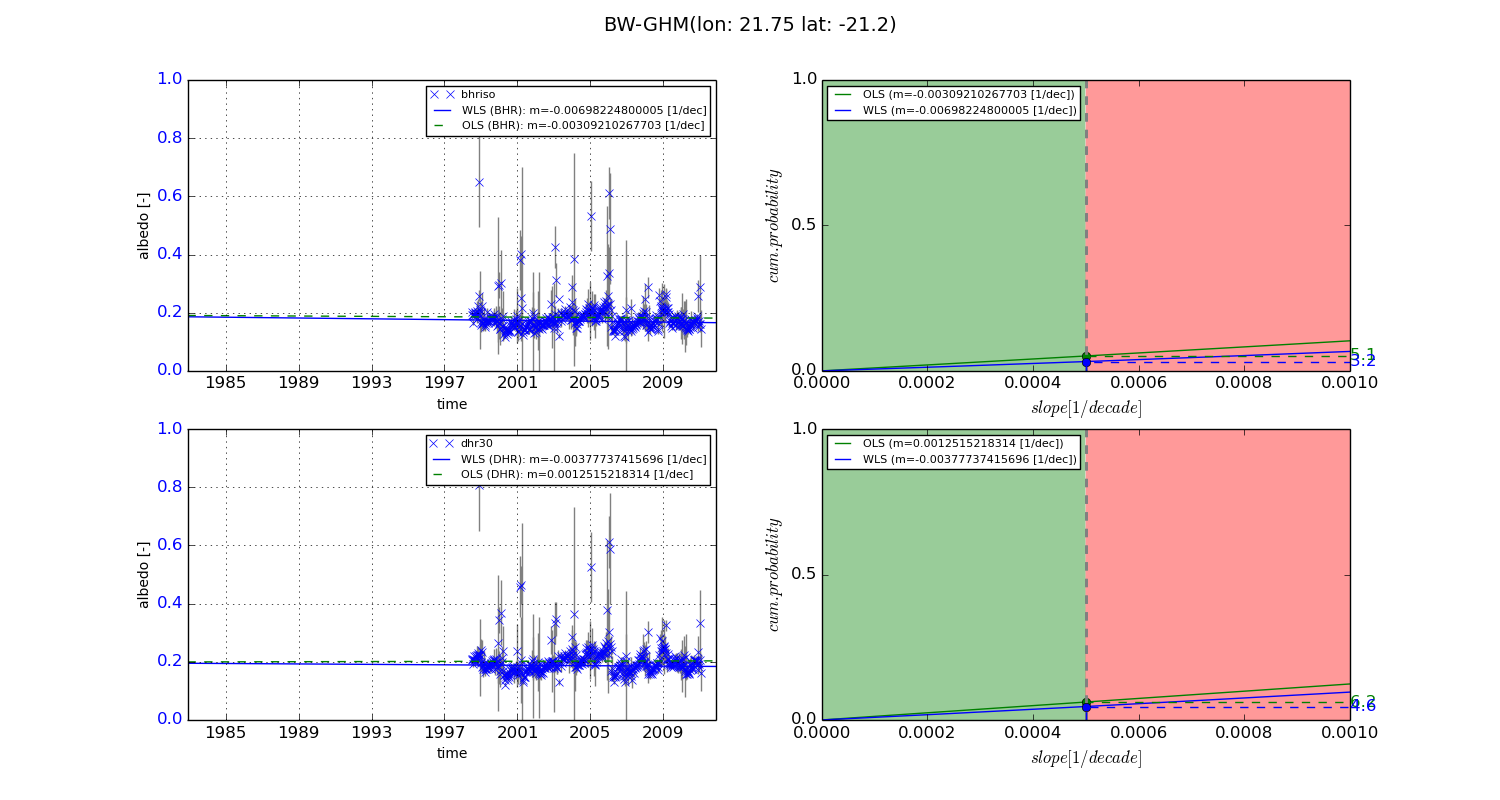
Temporal stability analysis

+000 deg (BHR)


BHR statistics

Temporal stability [1/decade]:


abs

rel


Weighted least square:

-0.014035128269


Ordinary least square:

-0.0136229709155


Probabilities that GCOS criteria is met:

Weighted least square:

2.4 %

Ordinary least square:

2.9 %


DHR statistics

Temporal stability [1/decade]:


abs

rel


Weighted least square:

-0.0126212599301


Ordinary least square:

-0.012981617376


Probabilities that GCOS criteria is met:

Weighted least square:

2.3 %

Ordinary least square:

2.8 %


+057/+063 deg (BHR)


BHR statistics

Temporal stability [1/decade]:


abs

rel


Weighted least square:

-0.00698224800005


Ordinary least square:

-0.00309210267703


Probabilities that GCOS criteria is met:

Weighted least square:

3.2 %

Ordinary least square:

5.1 %


DHR statistics

Temporal stability [1/decade]:


abs

rel


Weighted least square:

-0.00377737415696


Ordinary least square:

0.0012515218314


Probabilities that GCOS criteria is met:

Weighted least square:

4.6 %

Ordinary least square:

6.2 %


Temporal anomaly analyis

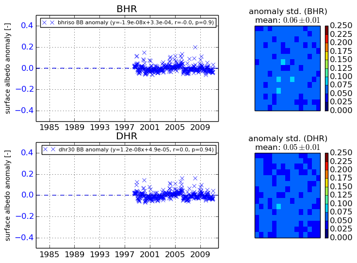
The variance of the temporal anomalies provides an additional measure about the stability of the signal AFTER removal of the mean seasonal cylce.
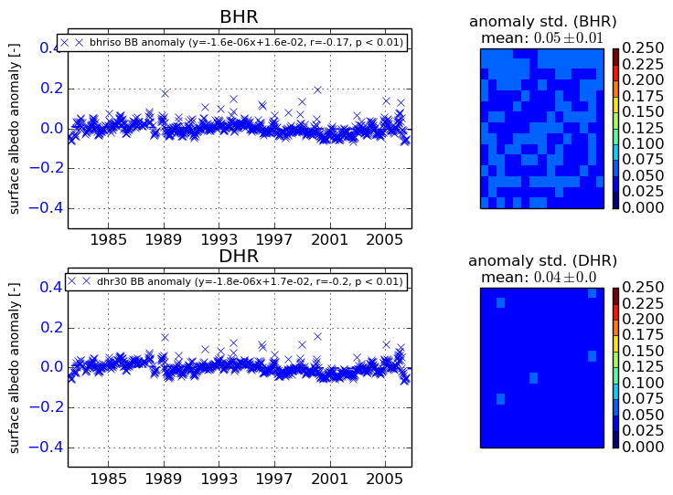
+000 deg


+057/+063 deg