CALIPSO_ASHBURN


Location

lon / lat [deg]: -77.4762 / 39.0659

Source network: AERONET


Geostationary surface albedo (GSA) data


“+000”


“+057/+063”


Landcover information (based on ESA CCI landcover data)


Landcover fractions @ 2km distance


Landcover fractions @ 20 km distance


Legend


Distance to open water bodies [km]:

2.29

Distance to urban areas [km]:

0.07


Radius: 1 km

Number of landcover classes:

2

Dominant landcover type:

190: urban areas

Fraction of dominant landcover type [%]:

88.0


Radius: 2 km

Number of landcover classes:

3

Dominant landcover type:

190: urban areas

Fraction of dominant landcover type [%]:

66.0


Radius: 5 km

Number of landcover classes:

8

Dominant landcover type:

190: urban areas

Fraction of dominant landcover type [%]:

50.0


Radius: 10 km

Number of landcover classes:

8

Dominant landcover type:

130: grassland

Fraction of dominant landcover type [%]:

41.0


Radius: 20 km

Number of landcover classes:

7

Dominant landcover type:

130: grassland

Fraction of dominant landcover type [%]:

55.0


Disturbances


Heterogeneity analysis

The heterogeneity analysis provides information about the spatial and temporal heterogeneity of the site.

Topography


Roman et al. (2009) index


St

9.77314527852

Rcv

0.0338268016614

Rse

0.0

Rst

-0.115088628853

Rsv

-0.158048184013


Height range @ 1km [m]

26

Height range @ 2km [m]

42

Height range @ 5km [m]

50

Height range @ 10km [m]

-999

Height range @ 20km [m]

-999


Variance slope @ 1 km

104

Variance slope @ 2 km

85

Variance slope @ 5 km

43

Variance slope @ 10 km

-999

Variance slope @ 20 km

-999


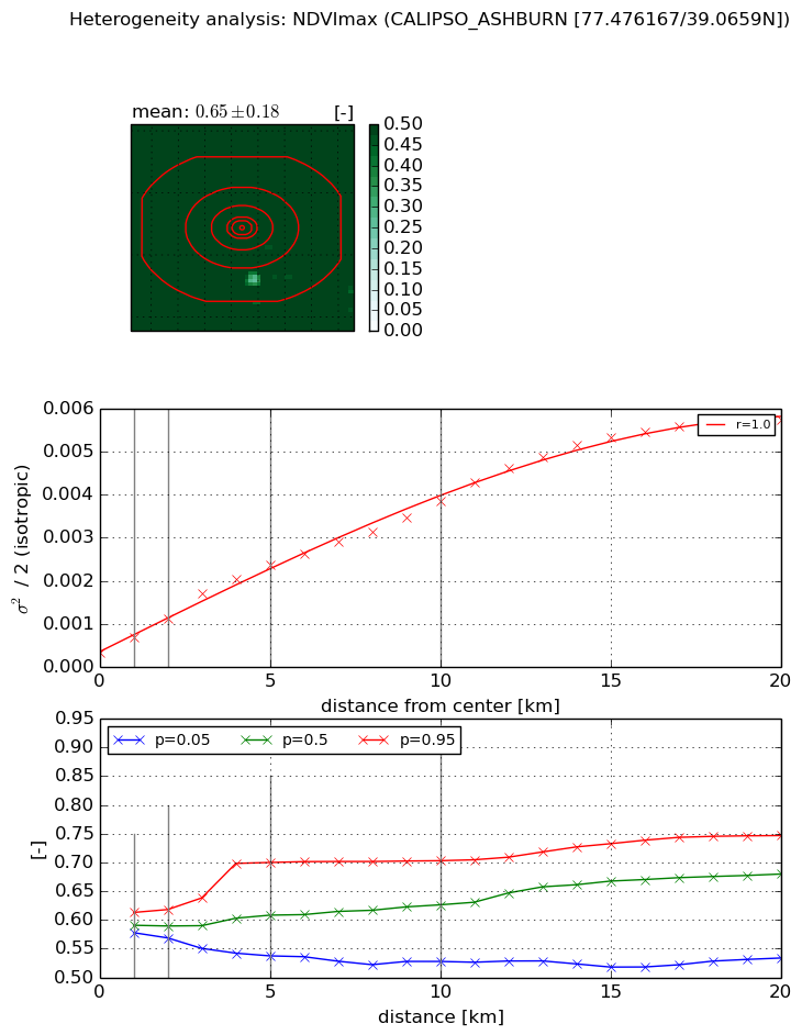
NDVI (max. NDVI composite)


Roman et al. (2009) index


St

1.79458040869

Rcv

0.56712320948

Rse

0.0

Rst

0.0298222535856

Rsv

1.07475449837


NDVI range @ 1km [-]

0.04

NDVI range @ 2km [-]

0.05

NDVI range @ 5km [-]

0.16

NDVI range @ 10km [-]

0.18

NDVI range @ 20km [-]

0.21


Variance slope @ 1 km

0.000377058624143

Variance slope @ 2 km

0.000400928709064

Variance slope @ 5 km

0.000422661420683

Variance slope @ 10 km

0.000343177907408

Variance slope @ 20 km

0.000283234205637


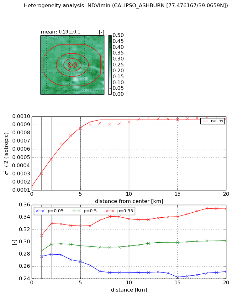
NDVI (min. NDVI composite)I


Roman et al. (2009) index


St

7.92769789178

Rcv

0.0481407248324

Rse

0.0

Rst

-0.00761201827535

Rsv

0.322667328009


NDVI range @ 1km [-]

0.03

NDVI range @ 2km [-]

0.05

NDVI range @ 5km [-]

0.06

NDVI range @ 10km [-]

0.09

NDVI range @ 20km [-]

0.1


NDVI slope @ 1 km

0.000157195763135

NDVI slope @ 2 km

0.000164376625337

NDVI slope @ 5 km

0.000146649605789

NDVI slope @ 10 km

7.52691581744e-05

NDVI slope @ 20 km

3.02160539604e-05


Temporal stability analysis

+000 deg (BHR)


BHR statistics

Temporal stability [1/decade]:


abs

rel


Weighted least square:

-99999.0


Ordinary least square:

-99999.0


Probabilities that GCOS criteria is met:

Weighted least square:

-99999.0 %

Ordinary least square:

-99999.0 %


DHR statistics

Temporal stability [1/decade]:


abs

rel


Weighted least square:

-99999.0


Ordinary least square:

-99999.0


Probabilities that GCOS criteria is met:

Weighted least square:

-99999.0 %

Ordinary least square:

-99999.0 %


+057/+063 deg (BHR)


BHR statistics

Temporal stability [1/decade]:


abs

rel


Weighted least square:

None


Ordinary least square:

None


Probabilities that GCOS criteria is met:

Weighted least square:

None %

Ordinary least square:

None %


DHR statistics

Temporal stability [1/decade]:


abs

rel


Weighted least square:

None


Ordinary least square:

None


Probabilities that GCOS criteria is met:

Weighted least square:

None %

Ordinary least square:

None %


Temporal anomaly analyis

The variance of the temporal anomalies provides an additional measure about the stability of the signal AFTER removal of the mean seasonal cylce.

+000 deg


+057/+063 deg