CALIPSO_ORMAND_MS


Location

lon / lat [deg]: -77.4546 / 38.8556

Source network: AERONET


Geostationary surface albedo (GSA) data


“+000”


“+057/+063”


Landcover information (based on ESA CCI landcover data)


Landcover fractions @ 2km distance


Landcover fractions @ 20 km distance


Legend


Distance to open water bodies [km]:

1.58

Distance to urban areas [km]:

0.15


Radius: 1 km

Number of landcover classes:

2

Dominant landcover type:

190: urban areas

Fraction of dominant landcover type [%]:

85.0


Radius: 2 km

Number of landcover classes:

5

Dominant landcover type:

190: urban areas

Fraction of dominant landcover type [%]:

73.0


Radius: 5 km

Number of landcover classes:

5

Dominant landcover type:

190: urban areas

Fraction of dominant landcover type [%]:

65.0


Radius: 10 km

Number of landcover classes:

6

Dominant landcover type:

190: urban areas

Fraction of dominant landcover type [%]:

53.0


Radius: 20 km

Number of landcover classes:

7

Dominant landcover type:

190: urban areas

Fraction of dominant landcover type [%]:

45.0


Disturbances


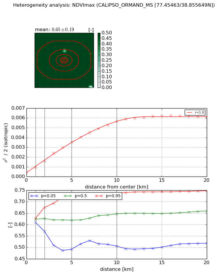
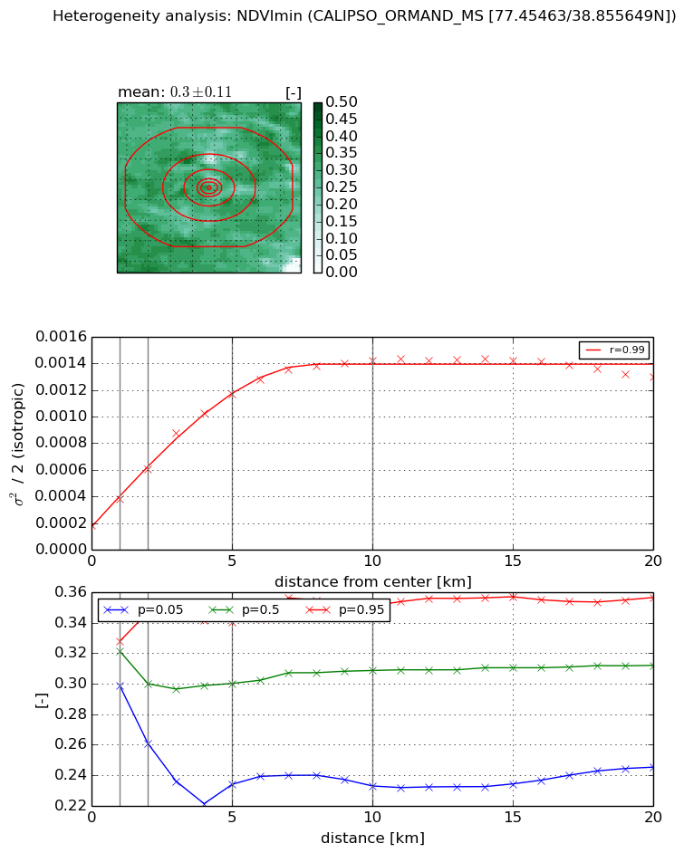
Heterogeneity analysis

The heterogeneity analysis provides information about the spatial and temporal heterogeneity of the site.

Topography


Roman et al. (2009) index


St

2.9681920577

Rcv

0.22704381627

Rse

0.0

Rst

-0.0809301951252

Rsv

-0.702742256853


Height range @ 1km [m]

17

Height range @ 2km [m]

26

Height range @ 5km [m]

49

Height range @ 10km [m]

-999

Height range @ 20km [m]

-999


Variance slope @ 1 km

74

Variance slope @ 2 km

66

Variance slope @ 5 km

49

Variance slope @ 10 km

-999

Variance slope @ 20 km

-999


NDVI (max. NDVI composite)


Roman et al. (2009) index


St

2.53283002545

Rcv

0.154065561109

Rse

0.0

Rst

-0.193392338416

Rsv

0.83698794558


NDVI range @ 1km [-]

0.02

NDVI range @ 2km [-]

0.1

NDVI range @ 5km [-]

0.23

NDVI range @ 10km [-]

0.23

NDVI range @ 20km [-]

0.23


Variance slope @ 1 km

0.000514997259671

Variance slope @ 2 km

0.000569115389067

Variance slope @ 5 km

0.000641332504277

Variance slope @ 10 km

0.000533157786682

Variance slope @ 20 km

0.000278932977186


NDVI (min. NDVI composite)I


Roman et al. (2009) index


St

7.862547299

Rcv

-0.0206063406907

Rse

0.0

Rst

-0.0848259458253

Rsv

0.276123446749


NDVI range @ 1km [-]

0.03

NDVI range @ 2km [-]

0.09

NDVI range @ 5km [-]

0.11

NDVI range @ 10km [-]

0.12

NDVI range @ 20km [-]

0.11


NDVI slope @ 1 km

0.000196759658956

NDVI slope @ 2 km

0.000211389518361

NDVI slope @ 5 km

0.000203811643132

NDVI slope @ 10 km

0.000125468969117

NDVI slope @ 20 km

4.38543313892e-05


Temporal stability analysis

+000 deg (BHR)


BHR statistics

Temporal stability [1/decade]:


abs

rel


Weighted least square:

-99999.0


Ordinary least square:

-99999.0


Probabilities that GCOS criteria is met:

Weighted least square:

-99999.0 %

Ordinary least square:

-99999.0 %


DHR statistics

Temporal stability [1/decade]:


abs

rel


Weighted least square:

-99999.0


Ordinary least square:

-99999.0


Probabilities that GCOS criteria is met:

Weighted least square:

-99999.0 %

Ordinary least square:

-99999.0 %


+057/+063 deg (BHR)


BHR statistics

Temporal stability [1/decade]:


abs

rel


Weighted least square:

None


Ordinary least square:

None


Probabilities that GCOS criteria is met:

Weighted least square:

None %

Ordinary least square:

None %


DHR statistics

Temporal stability [1/decade]:


abs

rel


Weighted least square:

None


Ordinary least square:

None


Probabilities that GCOS criteria is met:

Weighted least square:

None %

Ordinary least square:

None %


Temporal anomaly analyis

The variance of the temporal anomalies provides an additional measure about the stability of the signal AFTER removal of the mean seasonal cylce.

+000 deg


+057/+063 deg