CALIPSO_SIGNAL_HILL


Location

lon / lat [deg]: -77.4404 / 38.753

Source network: AERONET


Geostationary surface albedo (GSA) data


“+000”


“+057/+063”


Landcover information (based on ESA CCI landcover data)


Landcover fractions @ 2km distance


Landcover fractions @ 20 km distance


Legend


Distance to open water bodies [km]:

4.5

Distance to urban areas [km]:

0.13


Radius: 1 km

Number of landcover classes:

2

Dominant landcover type:

190: urban areas

Fraction of dominant landcover type [%]:

62.0


Radius: 2 km

Number of landcover classes:

4

Dominant landcover type:

190: urban areas

Fraction of dominant landcover type [%]:

63.0


Radius: 5 km

Number of landcover classes:

5

Dominant landcover type:

190: urban areas

Fraction of dominant landcover type [%]:

47.0


Radius: 10 km

Number of landcover classes:

6

Dominant landcover type:

190: urban areas

Fraction of dominant landcover type [%]:

35.0


Radius: 20 km

Number of landcover classes:

6

Dominant landcover type:

190: urban areas

Fraction of dominant landcover type [%]:

39.0


Disturbances


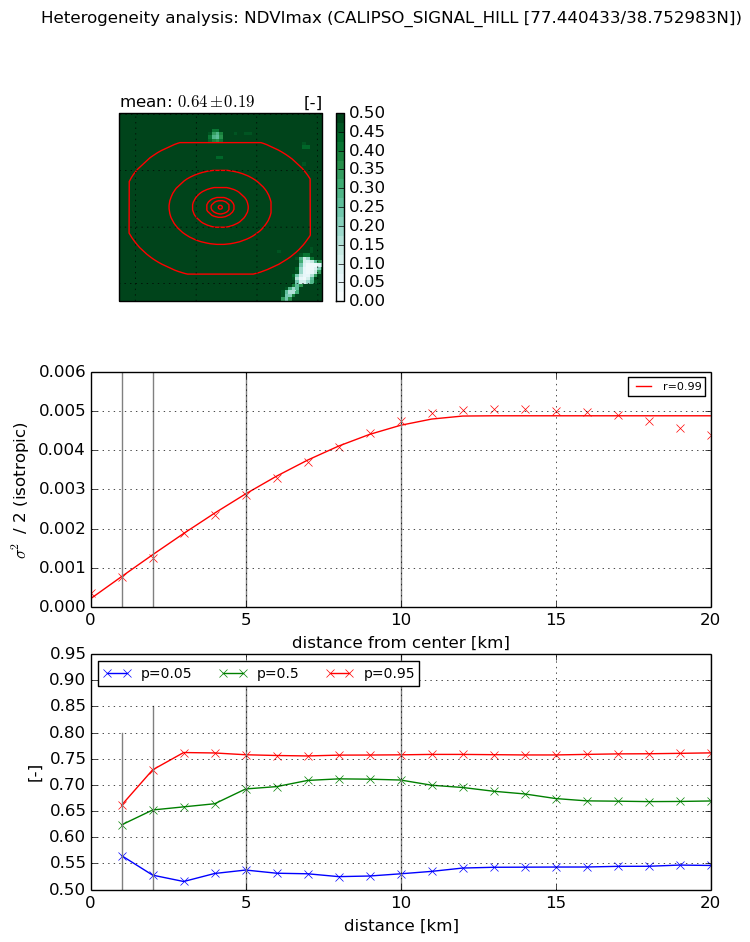
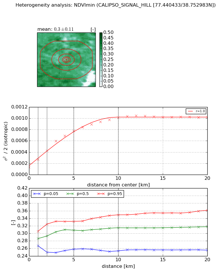
Heterogeneity analysis

The heterogeneity analysis provides information about the spatial and temporal heterogeneity of the site.

Topography


Roman et al. (2009) index


St

0.00397683559962

Rcv

0.310451907667

Rse

0.0

Rst

-0.0949805812676

Rsv

753.963191722


Height range @ 1km [m]

25

Height range @ 2km [m]

27

Height range @ 5km [m]

42

Height range @ 10km [m]

-999

Height range @ 20km [m]

-999


Variance slope @ 1 km

111

Variance slope @ 2 km

78

Variance slope @ 5 km

36

Variance slope @ 10 km

-999

Variance slope @ 20 km

-999


NDVI (max. NDVI composite)


Roman et al. (2009) index


St

1.72305982783

Rcv

-0.0466800586353

Rse

0.0

Rst

0.0634352198129

Rsv

1.63097342407


NDVI range @ 1km [-]

0.1

NDVI range @ 2km [-]

0.2

NDVI range @ 5km [-]

0.22

NDVI range @ 10km [-]

0.23

NDVI range @ 20km [-]

0.22


Variance slope @ 1 km

0.000401587738682

Variance slope @ 2 km

0.000444130918607

Variance slope @ 5 km

0.000512244670433

Variance slope @ 10 km

0.000452458642519

Variance slope @ 20 km

0.000212971845936


NDVI (min. NDVI composite)I


Roman et al. (2009) index


St

7.65338073872

Rcv

-0.190865006481

Rse

0.0

Rst

0.0813625856027

Rsv

-0.119756042655


NDVI range @ 1km [-]

0.04

NDVI range @ 2km [-]

0.07

NDVI range @ 5km [-]

0.07

NDVI range @ 10km [-]

0.1

NDVI range @ 20km [-]

0.11


NDVI slope @ 1 km

0.000135480389767

NDVI slope @ 2 km

0.000146015461358

NDVI slope @ 5 km

0.000132989235655

NDVI slope @ 10 km

8.62528194942e-05

NDVI slope @ 20 km

3.63631174866e-05


Temporal stability analysis

+000 deg (BHR)


BHR statistics

Temporal stability [1/decade]:


abs

rel


Weighted least square:

-99999.0


Ordinary least square:

-99999.0


Probabilities that GCOS criteria is met:

Weighted least square:

-99999.0 %

Ordinary least square:

-99999.0 %


DHR statistics

Temporal stability [1/decade]:


abs

rel


Weighted least square:

-99999.0


Ordinary least square:

-99999.0


Probabilities that GCOS criteria is met:

Weighted least square:

-99999.0 %

Ordinary least square:

-99999.0 %


+057/+063 deg (BHR)


BHR statistics

Temporal stability [1/decade]:


abs

rel


Weighted least square:

None


Ordinary least square:

None


Probabilities that GCOS criteria is met:

Weighted least square:

None %

Ordinary least square:

None %


DHR statistics

Temporal stability [1/decade]:


abs

rel


Weighted least square:

None


Ordinary least square:

None


Probabilities that GCOS criteria is met:

Weighted least square:

None %

Ordinary least square:

None %


Temporal anomaly analyis

The variance of the temporal anomalies provides an additional measure about the stability of the signal AFTER removal of the mean seasonal cylce.

+000 deg


+057/+063 deg


By continuing to use this website, you are giving consent to analytic cookies being used. For more information on how EUMETSAT uses data and how you can disable this, please view this web page: Analytics Cookie Policy