CAMAGUEY


Location

lon / lat [deg]: -77.8499 / 21.4223

Source network: AERONET


Geostationary surface albedo (GSA) data


“+000”


“+057/+063”


Landcover information (based on ESA CCI landcover data)


Landcover fractions @ 2km distance


Landcover fractions @ 20 km distance


Legend


Distance to open water bodies [km]:

6.87

Distance to urban areas [km]:

0.75


Radius: 1 km

Number of landcover classes:

3

Dominant landcover type:

130: grassland

Fraction of dominant landcover type [%]:

78.0


Radius: 2 km

Number of landcover classes:

5

Dominant landcover type:

130: grassland

Fraction of dominant landcover type [%]:

82.0


Radius: 5 km

Number of landcover classes:

6

Dominant landcover type:

130: grassland

Fraction of dominant landcover type [%]:

77.0


Radius: 10 km

Number of landcover classes:

8

Dominant landcover type:

11: cropland, rainfed, herbaceous cover

Fraction of dominant landcover type [%]:

37.0


Radius: 20 km

Number of landcover classes:

8

Dominant landcover type:

11: cropland, rainfed, herbaceous cover

Fraction of dominant landcover type [%]:

48.0


Disturbances


Heterogeneity analysis

The heterogeneity analysis provides information about the spatial and temporal heterogeneity of the site.

Topography


Roman et al. (2009) index


St

1.71039500426

Rcv

0.631861348018

Rse

0.0

Rst

-0.0631958715908

Rsv

1.05892358162


Height range @ 1km [m]

7

Height range @ 2km [m]

11

Height range @ 5km [m]

24

Height range @ 10km [m]

-999

Height range @ 20km [m]

-999


Variance slope @ 1 km

21

Variance slope @ 2 km

22

Variance slope @ 5 km

20

Variance slope @ 10 km

-999

Variance slope @ 20 km

-999


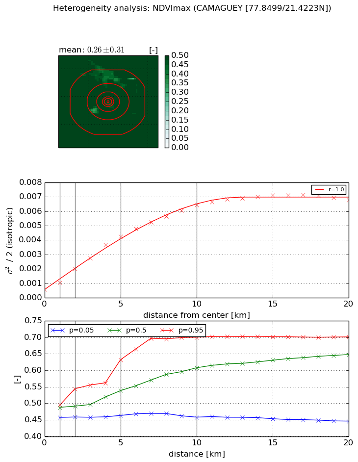
NDVI (max. NDVI composite)


Roman et al. (2009) index


St

2.70336942657

Rcv

0.564093210177

Rse

0.0

Rst

-0.159671857281

Rsv

0.385961176584


NDVI range @ 1km [-]

0.04

NDVI range @ 2km [-]

0.09

NDVI range @ 5km [-]

0.17

NDVI range @ 10km [-]

0.24

NDVI range @ 20km [-]

0.26


Variance slope @ 1 km

0.000497205042906

Variance slope @ 2 km

0.00072266878679

Variance slope @ 5 km

0.000771981765661

Variance slope @ 10 km

0.000601358981607

Variance slope @ 20 km

0.000308171977031


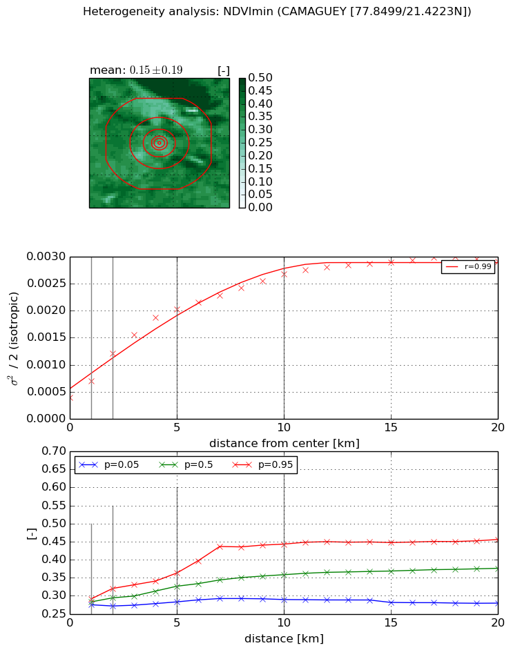
NDVI (min. NDVI composite)I


Roman et al. (2009) index


St

3.22528973546

Rcv

0.421535083352

Rse

0.0

Rst

-0.103426192783

Rsv

0.405187716998


NDVI range @ 1km [-]

0.02

NDVI range @ 2km [-]

0.05

NDVI range @ 5km [-]

0.08

NDVI range @ 10km [-]

0.15

NDVI range @ 20km [-]

0.18


NDVI slope @ 1 km

0.000309340537703

NDVI slope @ 2 km

0.000409400822598

NDVI slope @ 5 km

0.000343072234456

NDVI slope @ 10 km

0.000219565984416

NDVI slope @ 20 km

0.000111495805424


Temporal stability analysis

+000 deg (BHR)


BHR statistics

Temporal stability [1/decade]:


abs

rel


Weighted least square:

-99999.0


Ordinary least square:

-99999.0


Probabilities that GCOS criteria is met:

Weighted least square:

-99999.0 %

Ordinary least square:

-99999.0 %


DHR statistics

Temporal stability [1/decade]:


abs

rel


Weighted least square:

-99999.0


Ordinary least square:

-99999.0


Probabilities that GCOS criteria is met:

Weighted least square:

-99999.0 %

Ordinary least square:

-99999.0 %


+057/+063 deg (BHR)


BHR statistics

Temporal stability [1/decade]:


abs

rel


Weighted least square:

None


Ordinary least square:

None


Probabilities that GCOS criteria is met:

Weighted least square:

None %

Ordinary least square:

None %


DHR statistics

Temporal stability [1/decade]:


abs

rel


Weighted least square:

None


Ordinary least square:

None


Probabilities that GCOS criteria is met:

Weighted least square:

None %

Ordinary least square:

None %


Temporal anomaly analyis

The variance of the temporal anomalies provides an additional measure about the stability of the signal AFTER removal of the mean seasonal cylce.

+000 deg


+057/+063 deg