CARTEL_X


Location

lon / lat [deg]: -71.9313 / 45.3793

Source network: AERONET


Geostationary surface albedo (GSA) data


“+000”


“+057/+063”


Landcover information (based on ESA CCI landcover data)


Landcover fractions @ 2km distance


Landcover fractions @ 20 km distance


Legend


Distance to open water bodies [km]:

1.65

Distance to urban areas [km]:

0.05


Radius: 1 km

Number of landcover classes:

4

Dominant landcover type:

190: urban areas

Fraction of dominant landcover type [%]:

75.0


Radius: 2 km

Number of landcover classes:

6

Dominant landcover type:

190: urban areas

Fraction of dominant landcover type [%]:

57.0


Radius: 5 km

Number of landcover classes:

6

Dominant landcover type:

190: urban areas

Fraction of dominant landcover type [%]:

51.0


Radius: 10 km

Number of landcover classes:

8

Dominant landcover type:

62: Tree cover, broadleaved, decidous (open 15-40%)

Fraction of dominant landcover type [%]:

40.0


Radius: 20 km

Number of landcover classes:

11

Dominant landcover type:

62: Tree cover, broadleaved, decidous (open 15-40%)

Fraction of dominant landcover type [%]:

36.0


Disturbances


Heterogeneity analysis

The heterogeneity analysis provides information about the spatial and temporal heterogeneity of the site.

Topography


Roman et al. (2009) index


St

7.63494124522

Rcv

0.0948203606037

Rse

0.0

Rst

-0.0737640115289

Rsv

0.224345960092


Height range @ 1km [m]

98

Height range @ 2km [m]

146

Height range @ 5km [m]

175

Height range @ 10km [m]

-999

Height range @ 20km [m]

-999


Variance slope @ 1 km

599

Variance slope @ 2 km

694

Variance slope @ 5 km

658

Variance slope @ 10 km

-999

Variance slope @ 20 km

-999


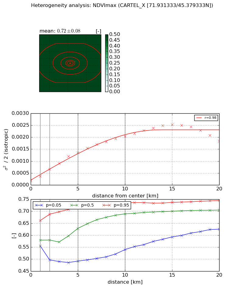
NDVI (max. NDVI composite)


Roman et al. (2009) index


St

9.80361304243

Rcv

-0.0557188485414

Rse

0.0

Rst

0.134791586766

Rsv

-0.115499194715


NDVI range @ 1km [-]

0.11

NDVI range @ 2km [-]

0.19

NDVI range @ 5km [-]

0.22

NDVI range @ 10km [-]

0.2

NDVI range @ 20km [-]

0.12


Variance slope @ 1 km

0.000190826338887

Variance slope @ 2 km

0.000243043820404

Variance slope @ 5 km

0.000245973559892

Variance slope @ 10 km

0.000190371518559

Variance slope @ 20 km

9.91418669286e-05


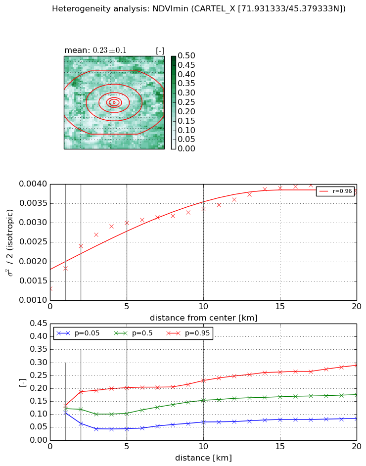
NDVI (min. NDVI composite)I


Roman et al. (2009) index


St

4.76269811844

Rcv

0.0291294986524

Rse

0.0

Rst

-0.147272049823

Rsv

0.45349350794


NDVI range @ 1km [-]

0.03

NDVI range @ 2km [-]

0.12

NDVI range @ 5km [-]

0.16

NDVI range @ 10km [-]

0.16

NDVI range @ 20km [-]

0.21


NDVI slope @ 1 km

0.000524869019456

NDVI slope @ 2 km

0.000549502074303

NDVI slope @ 5 km

0.000344531016103

NDVI slope @ 10 km

0.000176218222463

NDVI slope @ 20 km

0.000103825230301


Temporal stability analysis

+000 deg (BHR)


BHR statistics

Temporal stability [1/decade]:


abs

rel


Weighted least square:

-99999.0


Ordinary least square:

-99999.0


Probabilities that GCOS criteria is met:

Weighted least square:

-99999.0 %

Ordinary least square:

-99999.0 %


DHR statistics

Temporal stability [1/decade]:


abs

rel


Weighted least square:

-99999.0


Ordinary least square:

-99999.0


Probabilities that GCOS criteria is met:

Weighted least square:

-99999.0 %

Ordinary least square:

-99999.0 %


+057/+063 deg (BHR)


BHR statistics

Temporal stability [1/decade]:


abs

rel


Weighted least square:

None


Ordinary least square:

None


Probabilities that GCOS criteria is met:

Weighted least square:

None %

Ordinary least square:

None %


DHR statistics

Temporal stability [1/decade]:


abs

rel


Weighted least square:

None


Ordinary least square:

None


Probabilities that GCOS criteria is met:

Weighted least square:

None %

Ordinary least square:

None %


Temporal anomaly analyis

The variance of the temporal anomalies provides an additional measure about the stability of the signal AFTER removal of the mean seasonal cylce.

+000 deg


+057/+063 deg


By continuing to use this website, you are giving consent to analytic cookies being used. For more information on how EUMETSAT uses data and how you can disable this, please view this web page: Analytics Cookie Policy