COLORADO


Location

lon / lat [deg]: -105.55 / 40.45

Source network: AERONET


Geostationary surface albedo (GSA) data


“+000”


“+057/+063”


Landcover information (based on ESA CCI landcover data)


Landcover fractions @ 2km distance


Landcover fractions @ 20 km distance


Legend


Distance to open water bodies [km]:

9.19

Distance to urban areas [km]:

6.0


Radius: 1 km

Number of landcover classes:

1

Dominant landcover type:

70: Tree cover, needleleaved, evergreen, closed to open (>15%)

Fraction of dominant landcover type [%]:

100.0


Radius: 2 km

Number of landcover classes:

1

Dominant landcover type:

70: Tree cover, needleleaved, evergreen, closed to open (>15%)

Fraction of dominant landcover type [%]:

100.0


Radius: 5 km

Number of landcover classes:

2

Dominant landcover type:

70: Tree cover, needleleaved, evergreen, closed to open (>15%)

Fraction of dominant landcover type [%]:

92.0


Radius: 10 km

Number of landcover classes:

4

Dominant landcover type:

70: Tree cover, needleleaved, evergreen, closed to open (>15%)

Fraction of dominant landcover type [%]:

77.0


Radius: 20 km

Number of landcover classes:

5

Dominant landcover type:

70: Tree cover, needleleaved, evergreen, closed to open (>15%)

Fraction of dominant landcover type [%]:

82.0


Disturbances


Heterogeneity analysis

The heterogeneity analysis provides information about the spatial and temporal heterogeneity of the site.

Topography


Roman et al. (2009) index


St

2.13888919573

Rcv

0.402570619325

Rse

0.0

Rst

-2.65820614218e-05

Rsv

-1.0


Height range @ 1km [m]

295

Height range @ 2km [m]

450

Height range @ 5km [m]

961

Height range @ 10km [m]

-999

Height range @ 20km [m]

-999


Variance slope @ 1 km

14653

Variance slope @ 2 km

15043

Variance slope @ 5 km

15534

Variance slope @ 10 km

-999

Variance slope @ 20 km

-999


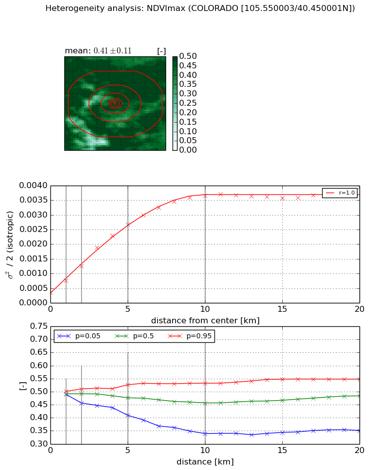
NDVI (max. NDVI composite)


Roman et al. (2009) index


St

1.44005657595

Rcv

0.78720091769

Rse

0.0

Rst

-0.296050856505

Rsv

-0.999999710578


NDVI range @ 1km [-]

0.01

NDVI range @ 2km [-]

0.05

NDVI range @ 5km [-]

0.12

NDVI range @ 10km [-]

0.19

NDVI range @ 20km [-]

0.2


Variance slope @ 1 km

0.000407869271198

Variance slope @ 2 km

0.000448142145576

Variance slope @ 5 km

0.000479179816015

Variance slope @ 10 km

0.000343268843835

Variance slope @ 20 km

0.000145794215362


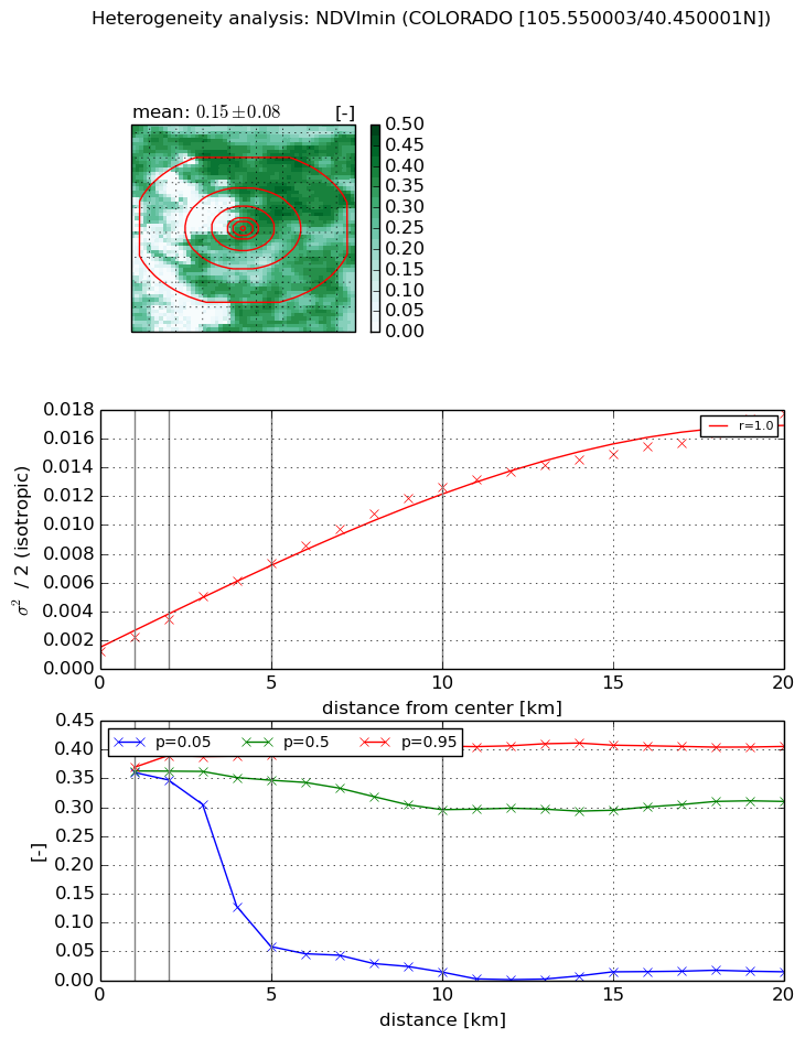
NDVI (min. NDVI composite)I


Roman et al. (2009) index


St

1.13220859296

Rcv

1.96455688408

Rse

0.0

Rst

-1.36706092232e-08

Rsv

0.685131524197


NDVI range @ 1km [-]

0.01

NDVI range @ 2km [-]

0.04

NDVI range @ 5km [-]

0.33

NDVI range @ 10km [-]

0.39

NDVI range @ 20km [-]

0.39


NDVI slope @ 1 km

0.00101010882649

NDVI slope @ 2 km

0.00110376110978

NDVI slope @ 5 km

0.00125763872044

NDVI slope @ 10 km

0.00117538990755

NDVI slope @ 20 km

0.000803777480494


Temporal stability analysis

+000 deg (BHR)


BHR statistics

Temporal stability [1/decade]:


abs

rel


Weighted least square:

None


Ordinary least square:

None


Probabilities that GCOS criteria is met:

Weighted least square:

None %

Ordinary least square:

None %


DHR statistics

Temporal stability [1/decade]:


abs

rel


Weighted least square:

None


Ordinary least square:

None


Probabilities that GCOS criteria is met:

Weighted least square:

None %

Ordinary least square:

None %


+057/+063 deg (BHR)


BHR statistics

Temporal stability [1/decade]:


abs

rel


Weighted least square:

None


Ordinary least square:

None


Probabilities that GCOS criteria is met:

Weighted least square:

None %

Ordinary least square:

None %


DHR statistics

Temporal stability [1/decade]:


abs

rel


Weighted least square:

None


Ordinary least square:

None


Probabilities that GCOS criteria is met:

Weighted least square:

None %

Ordinary least square:

None %


Temporal anomaly analyis

The variance of the temporal anomalies provides an additional measure about the stability of the signal AFTER removal of the mean seasonal cylce.

+000 deg


+057/+063 deg