DAVOS


Location

lon / lat [deg]: 9.8438 / 46.8129

Source network: AERONET


Geostationary surface albedo (GSA) data


“+000”


“+057/+063”


Landcover information (based on ESA CCI landcover data)


Landcover fractions @ 2km distance


Landcover fractions @ 20 km distance


Legend


Distance to open water bodies [km]:

0.45

Distance to urban areas [km]:

0.07


Radius: 1 km

Number of landcover classes:

4

Dominant landcover type:

130: grassland

Fraction of dominant landcover type [%]:

40.0


Radius: 2 km

Number of landcover classes:

6

Dominant landcover type:

70: Tree cover, needleleaved, evergreen, closed to open (>15%)

Fraction of dominant landcover type [%]:

39.0


Radius: 5 km

Number of landcover classes:

8

Dominant landcover type:

70: Tree cover, needleleaved, evergreen, closed to open (>15%)

Fraction of dominant landcover type [%]:

36.0


Radius: 10 km

Number of landcover classes:

10

Dominant landcover type:

130: grassland

Fraction of dominant landcover type [%]:

33.0


Radius: 20 km

Number of landcover classes:

11

Dominant landcover type:

130: grassland

Fraction of dominant landcover type [%]:

30.0


Disturbances


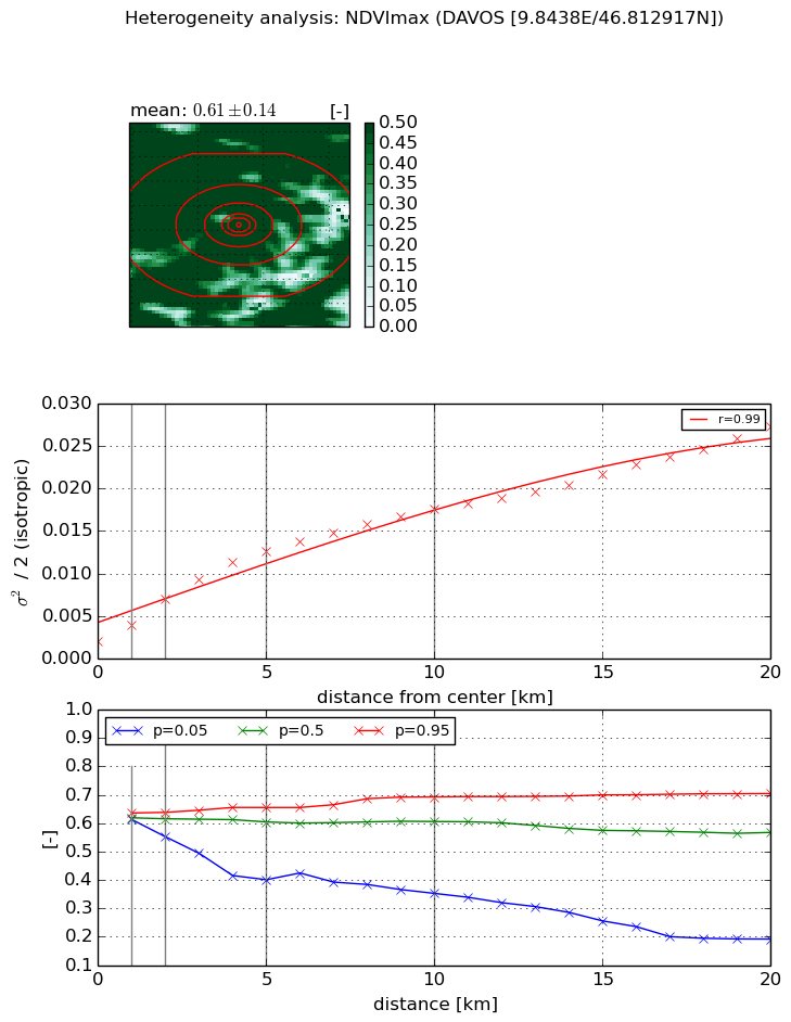
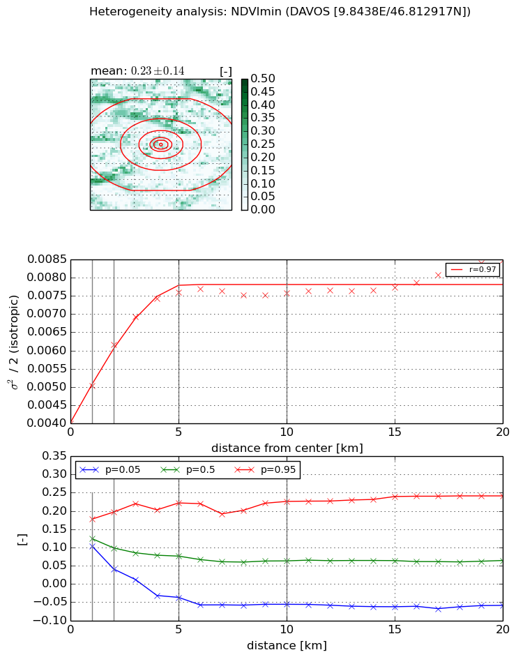
Heterogeneity analysis

The heterogeneity analysis provides information about the spatial and temporal heterogeneity of the site.

Topography


Roman et al. (2009) index


St

5.16367243961

Rcv

0.0986742918817

Rse

0.0

Rst

-0.0461310987459

Rsv

0.43617646581


Height range @ 1km [m]

244

Height range @ 2km [m]

622

Height range @ 5km [m]

960

Height range @ 10km [m]

-999

Height range @ 20km [m]

-999


Variance slope @ 1 km

31749

Variance slope @ 2 km

35942

Variance slope @ 5 km

26410

Variance slope @ 10 km

-999

Variance slope @ 20 km

-999


NDVI (max. NDVI composite)


Roman et al. (2009) index


St

1.82654758916e-07

Rcv

0.655398640194

Rse

0.0

Rst

0.197661346249

Rsv

16424427.4936


NDVI range @ 1km [-]

0.02

NDVI range @ 2km [-]

0.09

NDVI range @ 5km [-]

0.25

NDVI range @ 10km [-]

0.34

NDVI range @ 20km [-]

0.51


Variance slope @ 1 km

0.00192787640721

Variance slope @ 2 km

0.00246531683681

Variance slope @ 5 km

0.00221037968504

Variance slope @ 10 km

0.00153200928022

Variance slope @ 20 km

0.00110832226251


NDVI (min. NDVI composite)I


Roman et al. (2009) index


St

1.59180182349

Rcv

0.466695697318

Rse

0.0

Rst

-0.256980320016

Rsv

1.16098070044


NDVI range @ 1km [-]

0.07

NDVI range @ 2km [-]

0.16

NDVI range @ 5km [-]

0.26

NDVI range @ 10km [-]

0.28

NDVI range @ 20km [-]

0.3


NDVI slope @ 1 km

0.00104315814332

NDVI slope @ 2 km

0.00107717252835

NDVI slope @ 5 km

0.000738821392272

NDVI slope @ 10 km

0.00030521461752

NDVI slope @ 20 km

0.00013437516806


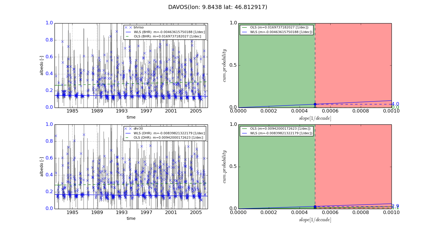
Temporal stability analysis

+000 deg (BHR)


BHR statistics

Temporal stability [1/decade]:


abs

rel


Weighted least square:

-0.00463615750188


Ordinary least square:

0.0169737182027


Probabilities that GCOS criteria is met:

Weighted least square:

4.0 %

Ordinary least square:

0.0 %


DHR statistics

Temporal stability [1/decade]:


abs

rel


Weighted least square:

-0.00839821322179


Ordinary least square:

0.00942000172623


Probabilities that GCOS criteria is met:

Weighted least square:

2.9 %

Ordinary least square:

1.1 %


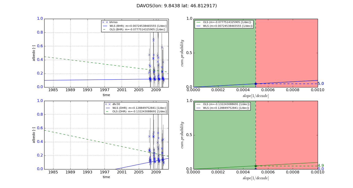
+057/+063 deg (BHR)


BHR statistics

Temporal stability [1/decade]:


abs

rel


Weighted least square:

0.00724538465555


Ordinary least square:

-0.0777514325905


Probabilities that GCOS criteria is met:

Weighted least square:

5.0 %

Ordinary least square:

5.0 %


DHR statistics

Temporal stability [1/decade]:


abs

rel


Weighted least square:

0.128849752841


Ordinary least square:

-0.132243088691


Probabilities that GCOS criteria is met:

Weighted least square:

0.0 %

Ordinary least square:

4.9 %


Temporal anomaly analyis

The variance of the temporal anomalies provides an additional measure about the stability of the signal AFTER removal of the mean seasonal cylce.
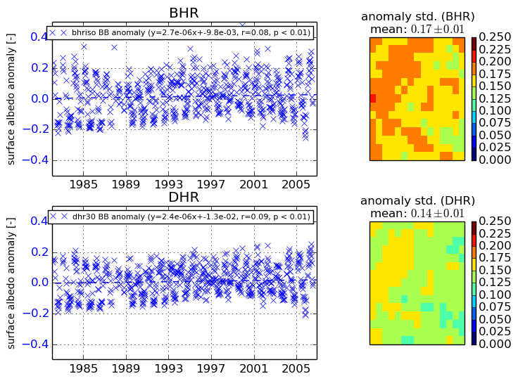
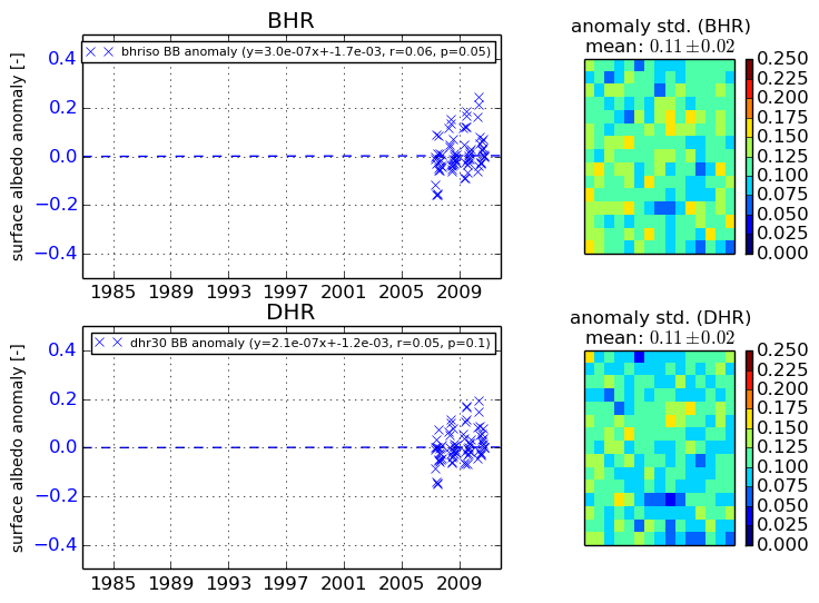
+000 deg


+057/+063 deg


By continuing to use this website, you are giving consent to analytic cookies being used. For more information on how EUMETSAT uses data and how you can disable this, please view this web page: Analytics Cookie Policy