DESERT_ROCK


Location

lon / lat [deg]: -116.0196 / 36.6232

Source network: SURFRAD


Geostationary surface albedo (GSA) data


“+000”


“+057/+063”


Landcover information (based on ESA CCI landcover data)


Landcover fractions @ 2km distance


Landcover fractions @ 20 km distance


Legend


Distance to open water bodies [km]:

23.53

Distance to urban areas [km]:

0.29


Radius: 1 km

Number of landcover classes:

2

Dominant landcover type:

120: Shrubland

Fraction of dominant landcover type [%]:

55.0


Radius: 2 km

Number of landcover classes:

2

Dominant landcover type:

120: Shrubland

Fraction of dominant landcover type [%]:

85.0


Radius: 5 km

Number of landcover classes:

2

Dominant landcover type:

120: Shrubland

Fraction of dominant landcover type [%]:

95.0


Radius: 10 km

Number of landcover classes:

2

Dominant landcover type:

120: Shrubland

Fraction of dominant landcover type [%]:

98.0


Radius: 20 km

Number of landcover classes:

2

Dominant landcover type:

120: Shrubland

Fraction of dominant landcover type [%]:

98.0


Disturbances


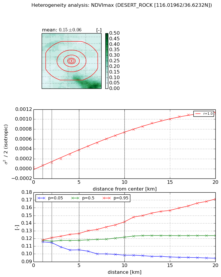
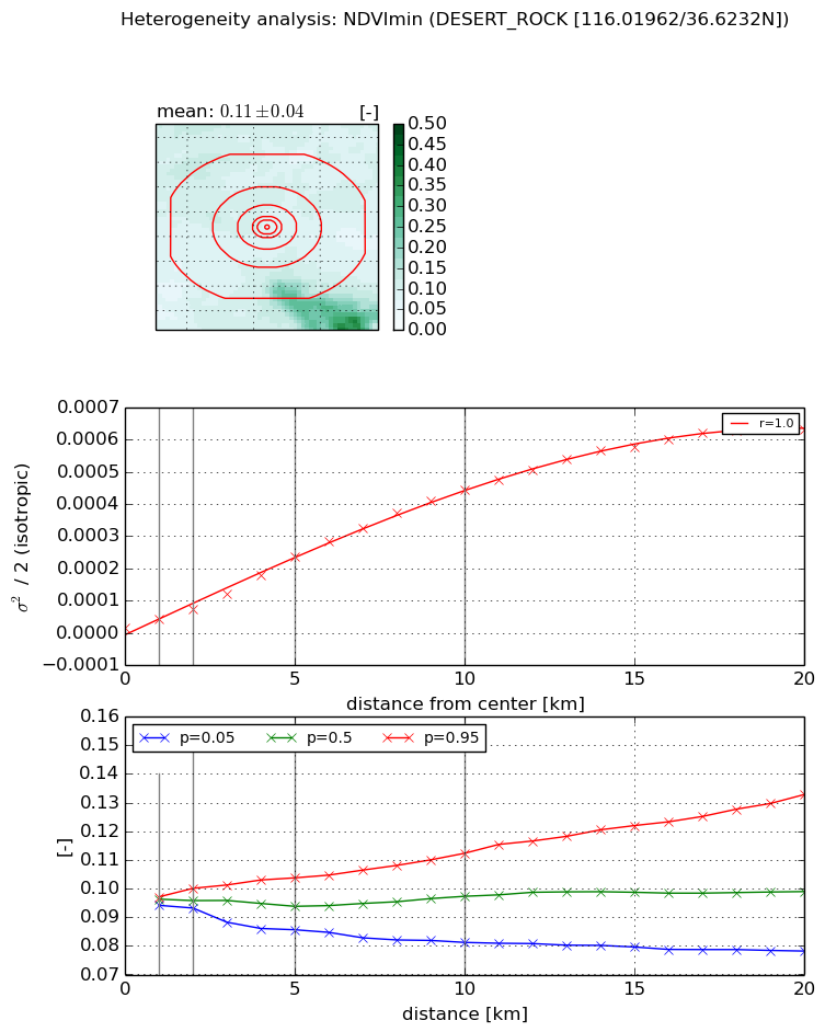
Heterogeneity analysis

The heterogeneity analysis provides information about the spatial and temporal heterogeneity of the site.

Topography


Roman et al. (2009) index


St

1.71453582301

Rcv

0.749744654827

Rse

0.0

Rst

-6.33313132907e-08

Rsv

-0.999999999766


Height range @ 1km [m]

41

Height range @ 2km [m]

85

Height range @ 5km [m]

230

Height range @ 10km [m]

-999

Height range @ 20km [m]

-999


Variance slope @ 1 km

741

Variance slope @ 2 km

962

Variance slope @ 5 km

1375

Variance slope @ 10 km

-999

Variance slope @ 20 km

-999


NDVI (max. NDVI composite)


Roman et al. (2009) index


St

7.15501174863e-08

Rcv

0.607004696214

Rse

0.0

Rst

0.254028324486

Rsv

41928651.4654


NDVI range @ 1km [-]

0.0

NDVI range @ 2km [-]

0.01

NDVI range @ 5km [-]

0.02

NDVI range @ 10km [-]

0.04

NDVI range @ 20km [-]

0.08


Variance slope @ 1 km

3.90997314596e-05

Variance slope @ 2 km

4.57587686551e-05

Variance slope @ 5 km

7.12984553008e-05

Variance slope @ 10 km

7.48043792887e-05

Variance slope @ 20 km

6.01896038067e-05


NDVI (min. NDVI composite)I


Roman et al. (2009) index


St

8.24944924017e-08

Rcv

0.494992616977

Rse

0.0

Rst

0.179642181127

Rsv

36366063.4426


NDVI range @ 1km [-]

0.0

NDVI range @ 2km [-]

0.01

NDVI range @ 5km [-]

0.02

NDVI range @ 10km [-]

0.03

NDVI range @ 20km [-]

0.05


NDVI slope @ 1 km

2.43406084572e-05

NDVI slope @ 2 km

2.84566891802e-05

NDVI slope @ 5 km

4.47207164176e-05

NDVI slope @ 10 km

4.56115666868e-05

NDVI slope @ 20 km

3.3487751338e-05


Temporal stability analysis

+000 deg (BHR)


BHR statistics

Temporal stability [1/decade]:


abs

rel


Weighted least square:

None


Ordinary least square:

None


Probabilities that GCOS criteria is met:

Weighted least square:

None %

Ordinary least square:

None %


DHR statistics

Temporal stability [1/decade]:


abs

rel


Weighted least square:

None


Ordinary least square:

None


Probabilities that GCOS criteria is met:

Weighted least square:

None %

Ordinary least square:

None %


+057/+063 deg (BHR)


BHR statistics

Temporal stability [1/decade]:


abs

rel


Weighted least square:

None


Ordinary least square:

None


Probabilities that GCOS criteria is met:

Weighted least square:

None %

Ordinary least square:

None %


DHR statistics

Temporal stability [1/decade]:


abs

rel


Weighted least square:

None


Ordinary least square:

None


Probabilities that GCOS criteria is met:

Weighted least square:

None %

Ordinary least square:

None %


Temporal anomaly analyis

The variance of the temporal anomalies provides an additional measure about the stability of the signal AFTER removal of the mean seasonal cylce.

+000 deg


+057/+063 deg